According to the latest storm information from the Philippine Atmospheric, Geophysical and Astronomical Services Administration (PAGASA), at 4:00 a.m. on December 23, the center of tropical depression Romina was located at about 10.8 degrees north latitude, 112.8 degrees east longitude, outside the Philippine forecast area (PAR), 165 km west of Pag-asa Island, Kalayaan, Palawan.
The tropical depression is moving northwest at 10 km/h with the strongest wind near the center of the tropical depression at about 55 km/h, gusting to 70 km/h, central pressure is 1002 hPa, wind radius 200 km.
According to the Japan Meteorological Agency, tropical depression Romina in the southern East Sea is likely to strengthen into a storm in the next 24-48 hours. If it strengthens into a storm, this will be the last storm of the 2024 storm season in the Northwest Pacific and East Sea storm center.
On satellite cloud images, it can be seen that cloud circulation has developed widely and covered almost the entire area of the central and southern East Sea. Operating ships should move ashore or leave the danger zone to ensure safety.
According to the Vietnam National Center for Hydro-Meteorological Forecasting, as of 1:00 a.m. on December 24, the center of the tropical depression is forecast to be at about 11.5 degrees north latitude, 111.5 degrees east longitude; in the sea southwest of the central East Sea. The strongest wind is level 8, gusting to level 10, moving west-northwest, traveling 10km per hour. The tropical depression is likely to strengthen into a storm. The natural disaster risk level is level 3 in the southern East Sea (including the Truong Sa archipelago), the sea southwest of the central East Sea.
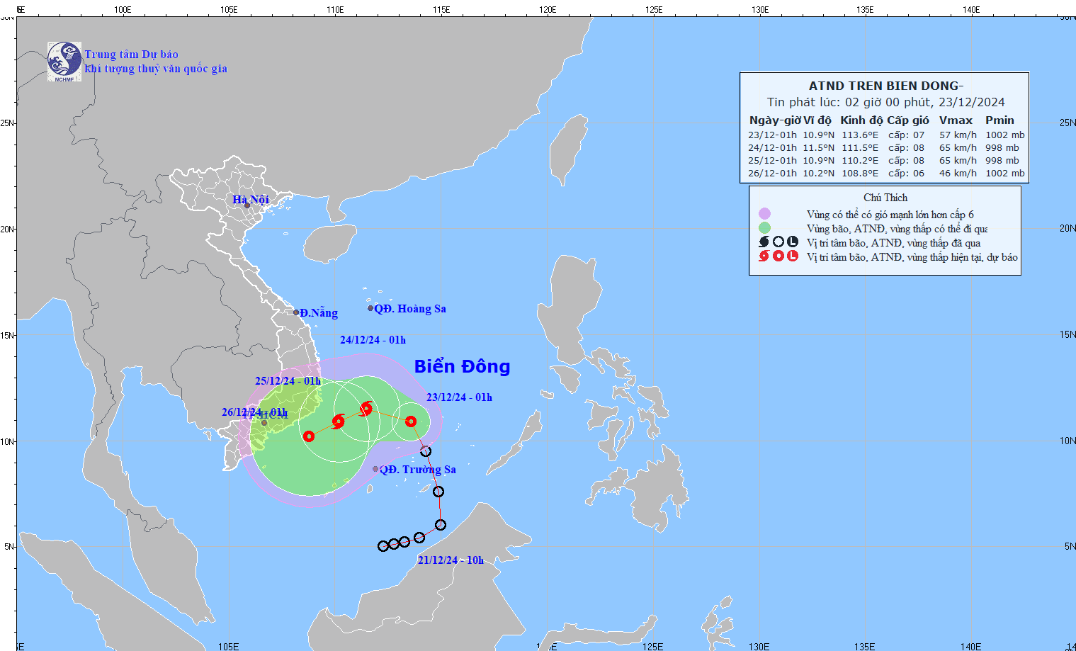
Forecast by 1:00 a.m. on December 25, the center of the tropical depression/storm is at about 10.9 degrees north latitude, 110.2 degrees east longitude; in the sea southwest of the central East Sea. The strongest wind is level 8, gusting to level 10, moving west southwest, about 5-10 km/h. Disaster risk level 3 in the southwest of the central East Sea, the sea northwest of the southern East Sea (including the Truong Sa archipelago).
On land, the Central and South Central provinces, the eastern Central Highlands, and the southern coastal region need to be extremely vigilant and pay attention to the heavy rain lasting from the evening and night of December 23 to 26, with the risk of water levels rising in river basins, causing damage to crops and property. Mountainous areas are at high risk of flash floods and landslides, and heavy rain in a short period of time can cause flooding in low-lying areas and residential areas.