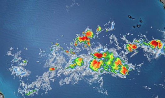
The latest low pressure strengthened into storm number 5 earlier than forecast

Song Minh |

According to the latest storm and tropical depression news , a storm warning has been issued as potential storm No. 5 threatens the Caribbean islands.

The 2024 Atlantic hurricane season is approaching its peak, and as expected, the hurricane formation zone is becoming more active as the US National Hurricane Center (NHC) issues a potential tropical storm advisory No. 5, is gradually forming east of the Leeward Islands.

NHC's storm forecast at 2:00 p.m. on August 10 local time shows that the low pressure with a wide band of showers and thunderstorms has become more active since August 7 and is currently located in the middle of the tropical Atlantic Ocean, about the middle of the Tropical Atlantic Ocean. Cape Verde Islands and the Lesser Antilles of the Caribbean. NHC gives a 40% chance of this system developing in the next 2 days and an 80% chance in the next 7 days.

However, on August 11, NHC announced that storm No. 5 had formed in the Atlantic Ocean, earlier than previously forecast.

The tropics have become more active in the past few weeks with the development of Hurricane Debby, which first made landfall in Florida (USA) and then made landfall a second time in South Carolina as a tropical storm.

And right next, depression Invest 98L began to form as it moved through the warm waters of the tropical Atlantic and eventually became the storm that is now known as storm number 5 .

Forecasting the path of storm No. 5. Photo: NHC/Fox Weather
Forecasting the path of storm No. 5. On August 12, the storm had a wind speed of 64 km/h (40 miles/h), and it is expected that by August 16, 2024, there will be winds of up to 177 km/h (110 miles/h). . Photo: NHC/Fox Weather

Since 2017, a potential tropical storm allows the NHC to issue routine advisories on a system that has not yet developed into a tropical depression or tropical storm but carries the threat of winds stronger than 62 km/h. h, landfall within 48 hours.

The rule also authorizes the issuance of tropical storm or hurricane watches and warnings for areas of highest concern about the storm's potential impacts.

The system is likely to become Tropical Storm Ernesto before reaching the Leeward Islands, the NHC said.

Currently, potential tropical storm number 5 is located in the tropical Central Atlantic Ocean.

Due to the threat that Potential Tropical Storm No. 5 poses to the Leeward Islands, as well as the territories of Puerto Rico and the US Virgin Islands, a tropical storm warning has been issued for Guadeloupe, St. Martin, St. Kitts, Nevis, Montserrat, Antigua, Barbuda and Anguilla.

Models forecasting the path of storm No. 5. Photo: NHC/Fox Weather
Models predict the path of storm No. 5 until August 16, 2024. Photo: NHC/Fox Weather

A tropical storm warning means tropical storm conditions are possible within 2 days.

According to the NHC, there will likely be additional warnings or watches for Puerto Rico.

Potential Tropical Storm No. 5 will continue to move west as it crosses the tropical Central Atlantic before beginning to turn northwest near the Caribbean Islands, the NHC said.

Current models show the storm will move north after approaching Puerto Rico.

The National Oceanic and Atmospheric Administration (NOAA) just updated its latest storm forecast last week, predicting an extremely severe hurricane season with 17-24 named storms, of which 8-13 The storm will be a hurricane. Of these, 4-7 storms will become major storms.

The official Atlantic hurricane season runs from June 1 to November 30.

Song Minh
TIN LIÊN QUAN

Áp thấp nhiệt đới dự kiến mạnh lên thành bão vài ngày tới

Khánh Minh |

NHC nâng dự báo khả năng áp thấp mới sẽ phát triển thành áp thấp nhiệt đới hoặc bão số 5 của mùa bão Đại Tây Dương.

Dự báo thời điểm áp thấp mới mạnh lên thành bão số 5 Ernesto

Thanh Hà |

Một áp thấp mới đang hình thành ở Đại Tây Dương có khả năng mạnh lên thành bão số 5 Ernesto.

Điều chỉnh dự báo khi mùa bão sắp vào giai đoạn bùng nổ

Khánh Minh |

Dự báo bão mới nhất vừa được công bố khi đỉnh điểm của mùa bão 2024 ở Đại Tây Dương đang đến gần.

Đình chỉ 2 chủ tịch xã ở Lào Cai do lơ là phòng chống bão lũ

Bảo Nguyên |

UBND huyện Bát Xát, tỉnh Lào Cai vừa ra quyết định đình chỉ công tác đối Chủ tịch UBND xã Trung Lèng Hồ và Pa Cheo do vi phạm quy định phòng, chống bão lũ.

Kịp thời vá vỡ đê sông tiếp giáp Bắc Ninh và Hà Nội

Đền Phú - Vân Trường |

Bắc Ninh - Đoạn đê bị vỡ khoảng 6m được lực lượng chức năng nhanh chóng vá lại, không gây ngập và thiệt hại cho khu dân cư.

Ukraina nói về kết quả cuộc tấn công tỉnh Kursk của Nga

Thanh Hà |

Ukraina cho rằng, cuộc tấn công của Ukraina vào khu vực Kursk đã làm chậm bước tiến của Nga trong khi phía Nga cho biết đã giành lại 10 ngôi làng.

"Phông bạt" trên Facebook là căn bệnh và cần thuốc chữa

AN NGUYÊN - THÙY TRANG |

Nhiều người bị phát hiện chỉnh sửa hình ảnh, làm giả hóa đơn chuyển khoản để “thổi phồng” số tiền và “phông bạt” trên Facebook nhằm đánh bóng tên tuổi.

Xe bán tải bị nước cuốn trôi, 1 phụ nữ tử vong ở Bình Dương

ĐÌNH TRỌNG |

Ngày 14.9, Công an thành phố Dĩ An, tỉnh Bình Dương đã bàn giao thi thể người phụ nữ đi xe bán tải bị nước cuốn, để gia đình lo hậu sự.

Tropical Depression Expected to Intensify into Typhoon in a Few Days

Khánh Minh |

NHC upgrades forecast for the potential of a low-pressure system to develop into a tropical depression or Hurricane 5 of the Atlantic hurricane season.

Forecast of low-pressure system strengthening into Typhoon No. 5 Ernesto

Thanh Hà |

A low-pressure system is currently forming in the Atlantic Ocean and has the potential to strengthen into Hurricane Ernesto, category 5.

Adjusting forecast as the typhoon season is about to enter the explosive phase

Khánh Minh |

Tropical Storm Forecast latest has just been released as the peak of the 2024 hurricane season in the Atlantic Ocean is approaching.