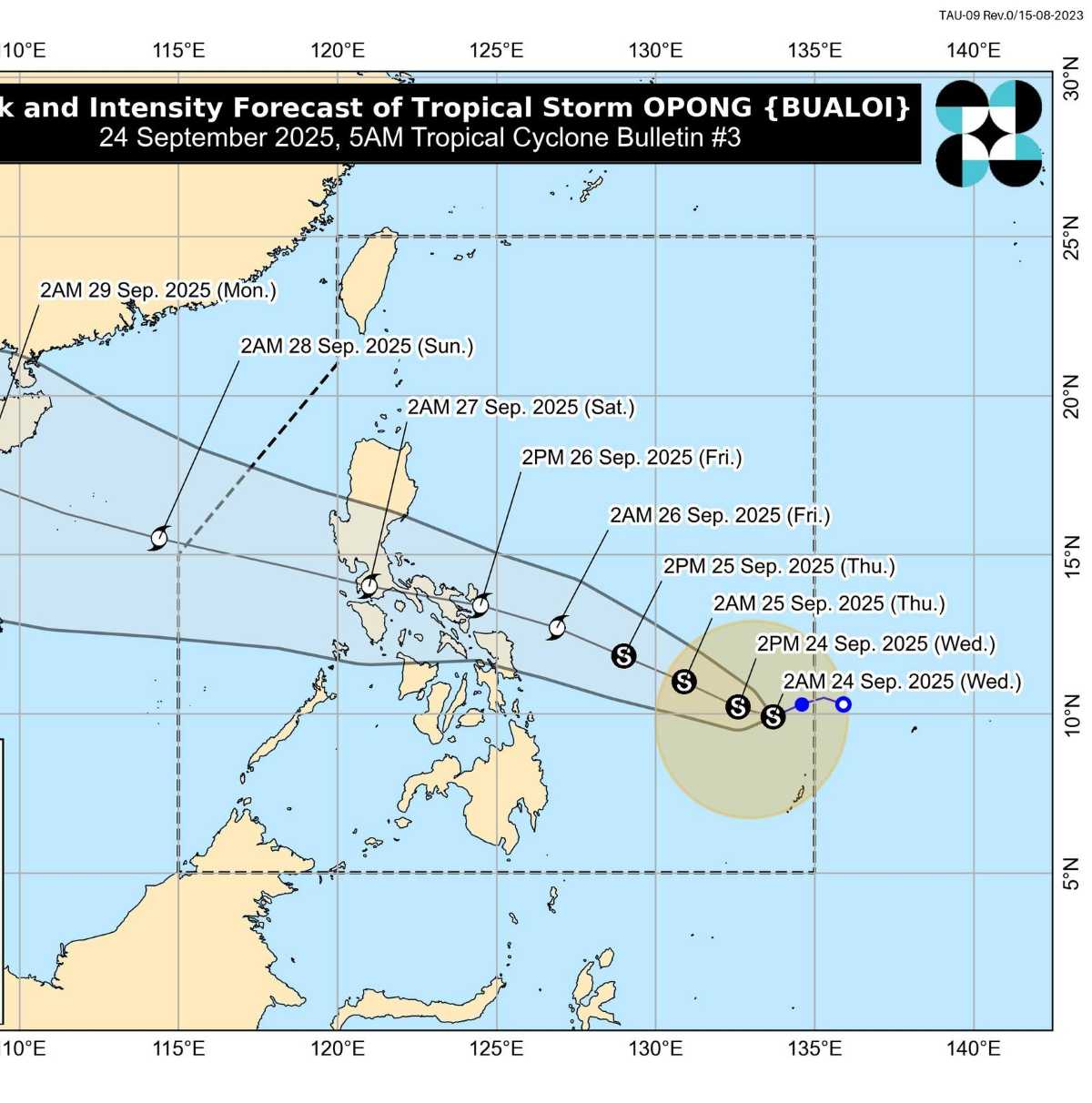
The latest storm information from the Philippine Atmospheric, Geophysical and Astronomical Services Administration (PAGASA) said that at 4:00 a.m. on September 24, the center of typhoon Bualoi (local name is Opong) was at about 9.8 degrees North latitude, 133.3 degrees East longitude, about 855km northeast of Mindanao.
Maximum winds near the center of the storm are 65 km/h, gusting to 80 km/h. The storm is moving in a West-Southwest direction at a speed of 20 km/h, with a range of strong winds extending up to 400 km around the center.
The weather forecast for the next 24 hours shows that Bualoi is unlikely to directly affect the weather in the Philippines. However, from tomorrow (September 25), heavy rain may appear in many places.
According to PAGASA's typhoon forecast, Bualoi will change direction to the West Northwest and head straight into the Eastern Visayas - Southern Luzon region. The storm is expected to make landfall in Bicol on the afternoon of September 26, then sweep across Southern Luzon until the morning of September 27. Bualoi may exit the Philippine Forecast Area (PAR) on the evening of September 27 or the morning of September 28, entering the South China Sea, becoming the 10th typhoon.
While moving inland, storm No. 10 Bualoi is likely to strengthen into a severe tropical storm tomorrow evening (September 25). The possibility of the storm continuing to intensify after crossing the Philippines cannot be ruled out.
GFS, ECMWF, JMA models all predict that storm No. 10 will strengthen after entering the East Sea. The surface temperature of the East Sea at this stage is generally at 28-29 degrees Celsius, although not the optimal surface temperature (30-31 degrees Celsius) for the development of the storm, but it is still within the favorable threshold for the storm to strengthen.
There are forecasts of 2 scenarios for storm No. 10 to move when it entered the middle of the East Sea around the evening of September 27
According to the GFS and CMC models: The storm will move in a West-Northwest direction parallel to and near the central coast from Da Nang to the North Central provinces and then make landfall in the area from Ha Tinh to Thanh Hoa. This scenario has a fairly high probability of about 70%.
According to the ECMWF model, the storm will move northward and enter Hainan Island. This model has a probability of 30%.
Regarding storm level, PAGASA is expected to expect the storm to strengthen into a severe tropical storm as early as 2:00 a.m. on September 25 and maintain its intensity when entering the East Sea, and at the same time, there is a possibility of strengthening.
Meanwhile, other models predict that when entering the middle of the East Sea, the storm can be as strong as level 12-13, and even higher when it is not obstructed by obstacles and is less affected by the continental high pressure. The storm's circulation is forecast to cause heavy rain in the North Central and Central regions of Vietnam from September 28-29.
Regarding super typhoon No. 9 Ragasa, at 4:00 a.m. on September 24, the center of the super typhoon was at about 21.3 degrees North latitude; 114.3 degrees East longitude, in the northern sea of the North East Sea, about 650km east of Mong Cai (Quang Ninh).
The strongest wind near the center of the super typhoon is level 15-16 (167-201 km/h), gusting over level 17. Moving in the West Northwest direction, speed about 20km/h.


