The latest storm information from the Philippine Atmospheric, Geophysical and Astronomical Services Administration (PAGASA) said that at 3:00 p.m. on September 22 local time (14:00 p.m. Vietnam time), the center of super typhoon Ragasa was located on Panuitan Island in Calayan, Cagayan Province, Northern Philippines, at about 19.4 degrees North latitude; 121.5 degrees East longitude.
The central pressure dropped sharply to 916mb, the strongest wind near the center of the super typhoon was 215-260 km/h, gusting over 295 km/h (above level 17). The super typhoon is moving in a West-Northwest direction at a speed of about 22-25 km/h.
Data shows that the waves around Northern Luzon are rising sharply. Coastal areas of Batanes and Babuyan Islands will have waves 12-14m high.
The coast of Cagayan and Ilocos Norte will have waves 10-12m high.
Coastal areas from Ilocos Sur to Pangasinan, Aurora and Isabela will have waves of 5-8m.
PAGASA warns of the risk of storm surge exceeding 3m in low-lying coastal areas of Batanes, Cagayan, Ilocos Norte and Ilocos Sur in the next 24 hours. All maritime activities in the northern and central Philippines have been advised to be suspended.
PAGASA issued its highest typhoon warning - Signal No. 5 in the Northern Luzon area, where millions of people face destructive typhoons and heavy rains. Some areas in Cagayan have begun to record flooding and landslides. People in dangerous areas are advised to evacuate urgently, strictly following the instructions of the authorities.
According to PAGASA's typhoon forecast, super typhoon Ragasa will continue to sweep across Babuyan and Calayan Islands this evening, then enter the East Sea, maintaining a very strong intensity before gradually decreasing as it approaches the Gulf of Tonkin on September 25.
The meteorological forecasters of all countries said that if it remains the same, super typhoon Ragasa could directly affect the coast from Quang Ninh to Ha Tinh in Vietnam, bringing gusts of level 12-13 and widespread heavy rain.
The Vietnam National Center for Hydro-Meteorological Forecasting predicts that by 1:00 p.m. on September 23, the center of the storm will be at 20.6 degrees North latitude, 117.4 degrees East longitude, in the northeastern sea area of the North East Sea. Intensity level 17, gust above level 17. Moving west-northwest, 20-25km/h and entering the East Sea, becoming storm No. 9.
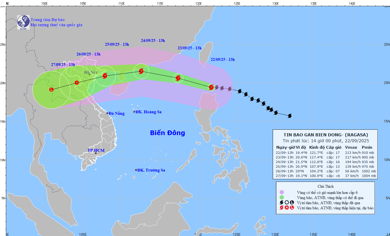
At 1:00 p.m. on September 24, the center of the storm was at 21.5 degrees North latitude, 112.6 degrees East longitude; in the northern sea area of the North East Sea, about 230km east of the Lusian Peninsula (China). Intensity level 15-16, gust above level 17. Moving west-northwest, 20-25 km/h.
It is forecasted that by 1:00 p.m. on September 25, the center of the storm will be at 20.9 degrees North latitude, 107.9 degrees East longitude; in the sea from Quang Ninh to Ninh Binh. Intensity level 12-13, gust level 16. Moving in the West Southwest direction, about 20 km/h and gradually weakening.
From September 24, the wind in the Gulf of Tonkin will gradually increase to level 6-7, then increase to level 8-10, the area near the storm's eye will have level 11-13, gusting above level 16, waves 5.0-7.0m high; the sea will be very rough.