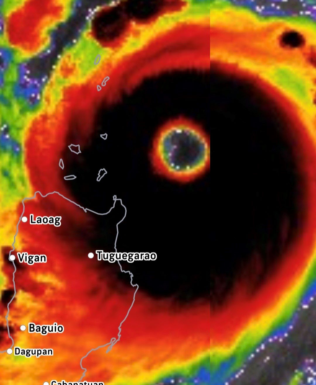
Japan's Himawari satellite image on the morning of September 22 showed a giant eye of the storm, more than 70km in diameter, returning fiercely in the sky of Northern Luzon (Philippines).
Super typhoon Ragasa has reached its peak with wind gusts of 270 km/h, becoming the strongest storm in the world in 2025 and is rolling straight towards the East Sea.
According to the latest storm information from the Tokyo Meteorological Center (RSMC), super typhoon Ragasa has officially dropped to 905 hPa - a record low this year. With this data, Ragasa surpassed super typhoons Yagi and Erin, holding the position of strongest storm on the planet in 2025 to date.
The international meteorological community is concerned that super typhoon Ragasa may reach the destructive threshold of super typhoon Haiyan (Haiyan) in 2013 - one of the most terrible super typhoons in modern history.
On September 22, the entire northern Luzon, Philippines is being directly affected. Heavy rain, strong gusts of wind, high waves flooding inland. In Punta, Aparri (Cagayan), sea water caused serious flooding.
Babuyan, Calayan, and Didicas islands are placed at Typhoon Warning Level 5 - the highest in the Philippines - with gusts forecast to exceed level 17. Local authorities have advised people to absolutely not leave shelters as the storm passes.
The center of the storm is forecast to pass through or make landfall in the Babuyan Islands at noon on September 22 or early afternoon.
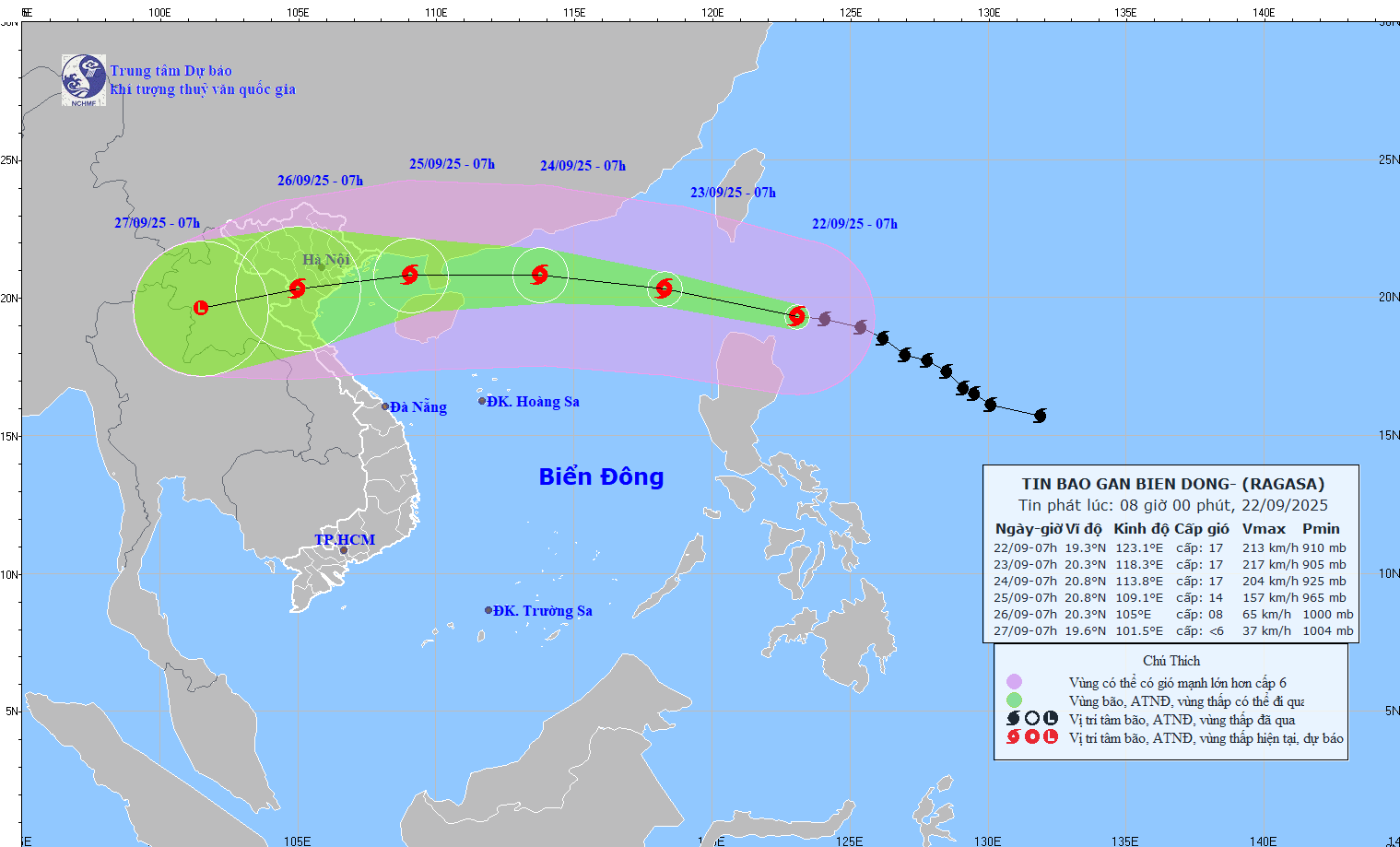
Major forecast centers are simultaneously forecasting that super typhoon Ragasa will enter the Gulf of Tonkin within the next 72 hours, with a gradual decrease in intensity but still extremely dangerous.
According to the storm forecast of the Vietnam National Center for Hydro-Meteorological Forecasting, the storm will have an intensity of level 17, then decrease to level 13-14 in the sea area east of the Gulf of Tonkin on the morning of September 25.
The Japan Meteorological Agency (JMA) forecasts the storm to reach its peak of level 16, reducing it to level 10-12 when it enters the North coast.
The US Joint Typhoon Warning Center (JTWC) forecasts maximum sustained wind gusts of 270 km/h, as the Thai Binh coast is still level 9-11.
The Hong Kong Meteorological Observatory (China) forecasts that the super typhoon will peak at level 17, entering Quang Ninh - Hai Phong at level 11-12.
Although there are slight differences in scenarios, all forecasts agree that Typhoon Ragasa (Typhoon No. 9) will make landfall from Quang Ninh to Ha Tinh on September 25, with the strongest winds of level 11-13.
The circulation of Typhoon Ragasa is forecast to cause heavy rain for many days in the North and North Central regions, from September 25 to 28. The coastal area of Quang Ninh - Hai Phong may experience gusts of wind of level 13-14 from the morning of September 25, with a high risk of flooding, landslides and high tides.
Meteorological experts recommend that people in coastal areas quickly reinforce their homes, anchor their boats and prepare evacuation plans.
Meanwhile, thousands of prayers were posted on Philippine social media as super typhoon Ragasa continued to devastate Northern Luzon. I can only pray that we will overcome this monsterious storm, a resident wrote.


