The latest storm and low pressure information updated on September 1 by the Philippine Atmospheric, Geophysical and Astronomical Services Administration (PAGASA) said that the low pressure near the East Sea located east of Eastern Visayas has strengthened into tropical depression Enteng.
"At 8 a.m. this morning, the low pressure area east of Eastern Visayas developed into Tropical Depression Enteng," the Philippine weather agency said.
According to PAGASA's Warning No. 1 on Tropical Depression Enteng issued at 11:00 a.m. on September 1, Enteng is expected to move mainly northwest to north-northwest on September 1, then turn north on September 2 and gradually strengthen.
Regarding the forecast path of the tropical depression near the East Sea Enteng, PAGASA does not rule out the possibility that this tropical depression will make landfall and pass through localities in the Bicol - Eastern Visayas region within the next 48 hours.
"Tropical depression Enteng may reach tropical storm level tomorrow (September 2)" - PAGASA's storm and tropical depression bulletin at noon on September 1 clearly stated.
"This is the fifth tropical storm this year" during the typhoon season in the Philippines, PAGASA weather expert Veronica Torres told Super Radyo dzBB.
According to PAGASA, from September 3 to the end of the forecast period, Typhoon Enteng is expected to move very erratically as it approaches the Luzon Strait. The storm's intensity may continue to increase during this period, with Typhoon Enteng forecast to reach typhoon level on September 5.
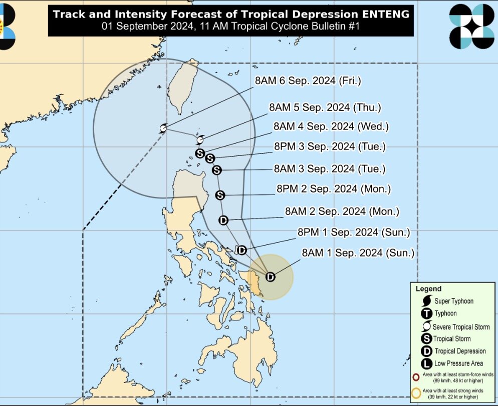
Currently, the center of Tropical Depression Enteng is located 120 kilometers northeast of Borongan City, Eastern Samar, or about 150 kilometers east of Catarman, Northern Samar. Enteng is moving north-northwest at 30 km/h. The tropical depression's sustained winds near the center are 45 km/h and gusts up to 55 km/h.
PAGASA's latest storm forecast said that Enteng is expected to approach the coastal area of Gigmoto, Catanduanes by 8 p.m. on September 1. Enteng is expected to be about 190 kilometers east of Baler, Aurora by September 2. Enteng is expected to be 145 kilometers from Aparri, Cagayan by September 3.
Enteng is forecast to approach Calayan, Cagayan (Babuyan Island) on September 4. Enteng will be in coastal waters of Uyugan, Batanes on September 5.
PAGASA's latest storm forecast also states that on September 6, Enteng will be 215 km west of Itbayat, Batanes, leaving the Philippines' forecast area.
Previously, the storm and tropical depression bulletin at 4:00 a.m. on September 1 of PAGASA said that this low pressure near the East Sea was 175 km east-northeast of Guiuan, Eastern Samar or 205 km east of Borongan City, Eastern Samar.