Tropical depression
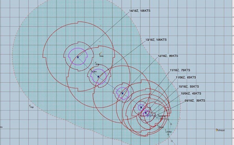
Typhoon Sinlaku forms, could become the strongest storm since the beginning of the season
|
Typhoon Sinlaku may strengthen into a strong typhoon of level 3 or 4 with winds of about 193 km/h when approaching Guam Island on the night of 13 or 14. 4.
World 24h: New low pressure forecast may become Typhoon Caloy
|
World news 9. 4: Mr. Trump criticizes Greenland for poor management; New low pressure forecast may become Typhoon Caloy...
Forecast of new tropical depression about to strengthen into a storm in the next 24 hours
|
Forecast for the next 24 hours, the tropical depression over the Northwest Pacific Ocean will move slowly in a westerly direction, with the possibility of strengthening into a storm.
Forecast of when Typhoon Caloy will appear, possibly strengthening into a super typhoon
|
The tropical depression may enter the Philippine Area of Responsibility (PAR) next week and strengthen into Typhoon Caloy.
World 24h: Forecast of new low pressure forming near the Philippines
|
World news 8: 4: New Zealand urges the US to deploy oil tankers to support the Pacific region; Forecast of new low pressure forming near the Philippines...
New low pressure forms near the Philippines, high risk of becoming a storm
|
A new low pressure area formed in eastern Mindanao, Philippines will enter the Philippines area next week.
When will the cold air end and widespread hot sun return
|
Weak cold air will only mainly affect on April 1. On April 3, the North will be sunny during the day, with hot sun in some places; from April 7, there is a possibility of widespread hot sun.
Forecast of cold air developments, trend of rain and hot sun in the coming month
|
In the next month, cold air will continue to operate in the North. In April, hot weather tends to increase in intensity and expand to the Mekong Delta.
Storm Nuri forms near the Philippines
|
The tropical depression near the Philippines has strengthened into tropical storm Nuri, the latest storm in March in the western Pacific basin.
Typhoon forecast near the East Sea from March to August
|
It is forecast that there will be about 6-14 storms near the East Sea in the next 5 months, in the context of weak La Nina officially ending.
Tropical depression near the Philippines has the potential to strengthen into a storm
|
The tropical depression in the east of the Philippines is being closely monitored as it is likely to strengthen into a storm in the next 24 hours.
New low pressure area formed near the Philippines, likely to strengthen
|
A new low pressure area has formed near the Philippines and is forecast to strengthen.
Forecast of thunderstorms in the area in the next 2 days, with heavy rain over 70mm in some places
|
Forecast for the North, Thanh Hoa and Nghe An from tomorrow, February 25th, there will be showers and scattered thunderstorms, with heavy rain in some places with rainfall over 70mm.
Is there a possibility of storms and low pressures in the next 3 months
|
Forecast from now until April, there is little chance of storms and tropical depressions appearing in the East Sea, but the weather diễn biến on the mainland has some noteworthy points.
Forecast of the possibility of storms and provinces at risk of rain in February
|
In February, it is forecast that there is little chance of storms appearing in the East Sea. The Central and South Central regions are likely to experience some widespread rains.


