The latest storm information from the Philippine weather agency (PAGASA) at 11:00 a.m. on October 25 said that storm Tra Mi (local name Kristine) slowed down slightly as it was about to leave the Philippine forecast area (PAR) in the East Sea while the tropical depression near the Philippines strengthened into tropical storm Kong-rey (local name Leon).
PAGASA reported that storm Tra Mi is moving west-northwest at a speed of 15 km/h, slightly down from the previous speed of 25 km/h.
More than 3.3 million people in the Philippines have been affected by Typhoon Tra Mi, with thousands still grappling with the aftermath of the latest storm churning over the South China Sea, officials said.
Typhoon Tra Mi is the 11th typhoon in the Philippines in the 2024 typhoon season and the first typhoon in November. Tra Mi is also the 6th typhoon in the East Sea.
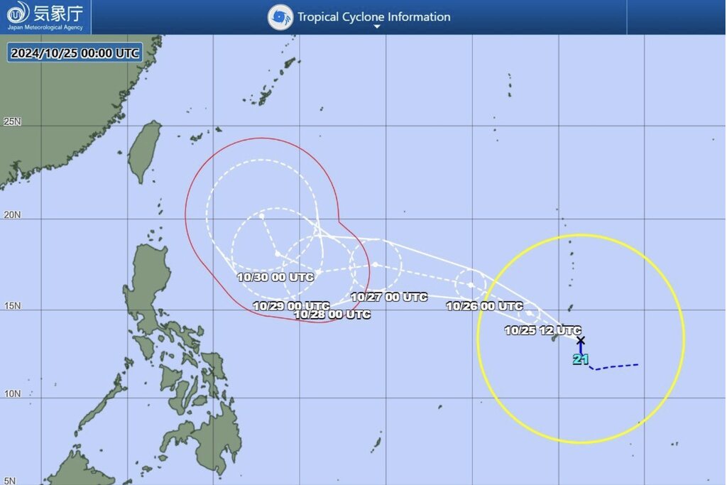
As Typhoon Tra Mi was churning over the South China Sea, the Japan Meteorological Agency (JMA) upgraded the tropical depression near Guam to a tropical storm. The new storm, internationally named Kong-rey, is forecast to enter the Philippine PAR forecast area on October 27 and will be named Leon according to the Philippine typhoon name list for the 2024 typhoon season.
The JMA's initial forecast shows that Kong-rey is east of Batanes, Philippines, and has not yet affected the weather in any part of the country. The storm is expected to move closer to southern Okinawa, Japan on October 30.
The latest storm and low pressure information from the US Navy's Joint Typhoon Warning Center (JTWC) said that Kong-rey (Typhoon No. 11 in Japan) is located 178 km east-southeast of the US Navy's Andersen Air Force Base in Guam. Typhoon Kong-rey has been moving west at a speed of 33 km/h over the past 6 hours.
Typhoon Kong-rey formed from a large low-pressure trough in the Mariana Islands. With warm sea surface and favorable winds from the upper-level low pressure to the west, Typhoon Kong-rey is forecast to move mainly west-northwest over the next 3 days. Typhoon forecasters at the JTWC said that with the current weather conditions, Typhoon Kong-rey will have winds of 100 km/h or more in the next 5 days and strengthen into a typhoon.
The CWA said a tropical depression near Guam intensified into Tropical Storm Kong-rey on the morning of October 25. At 8 a.m., the storm was about 2,770 kilometers east-southeast of Cape Eluanbi, the southernmost point of Taiwan. However, in its latest forecast, the CWA was still uncertain about the storm's impact on the island's weather.
Kong-rey is the name of the storm given by Cambodia, referring to a mountain and also the name of a girl in Khmer legend. The storm has wind speeds of up to 1,300 km/h, becoming the second strongest tropical cyclone in the western Pacific basin this year.