The latest storm and low pressure information from the Philippine Atmospheric, Geophysical and Astronomical Services Administration (PAGASA) on the afternoon of October 24 said that a new low pressure (10d) formed outside the Philippine Forecast Area (PAR) and is likely to strengthen into a tropical depression in the next 24 hours.
According to the most recent monitoring time, at around 8:40 a.m. on October 24, the new low pressure near the Philippines was located 2,295 km east of northeast Mindanao, Philippines, outside the Philippines' forecast area.
PAGASA warned that the low pressure area east of Mindanao is likely to strengthen into a tropical storm.
"In the next 24 hours, there is a high possibility that this low pressure will strengthen into a tropical depression or a weak storm. However, in the next 3 days, this low pressure will still be far from the mainland and is not expected to directly affect the Philippines" - Philippine weather expert Benison Estareja shared.
PAGASA said that the new low pressure system, when it enters the Philippine forecast area within the next 24 hours, will be locally named Leon.
Previously, PAGASA's storm and low pressure forecast model predicted that from October 23 to 29, there is a possibility of a low pressure entering the northeastern boundary of the PAR and then rotating towards Japan.
PAGASA weather service assistant director Chris Perez shared in an interview on Balitanghali that the potential low pressure forecast named Leon will cause rain in both Northern Luzon and Central Luzon.
In addition to the low pressure area (10d), another low pressure area (10e) is also being monitored within PAGASA's monitoring area. The possibility of low pressure area 10e strengthening into a tropical depression within the next 24 hours is low.
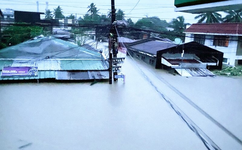
The new low pressure area appeared in the context of Typhoon Trami just making landfall in Luzon, Philippines, causing heavy rain and severe flooding in many areas of the country. When making landfall in the Philippines, the strongest wind near the center of Typhoon Trami was 95 km/h, gusting up to 160 km/h. The storm is expected to weaken slightly as it passes through Northern Luzon due to interaction with the mainland.
Storm Trami is continuing to move west-northwest, entering the East Sea. Typhoon Trami is forecast to leave the Philippine forecast area in the afternoon of October 25.
The latest update on Typhoon Trami at 2:00 p.m. on October 24 from PAGASA said that the center of the storm is in the coastal waters of Santa Cruz, Ilocos Sur, Philippines. The storm is moving southwest at a speed of 15 km/h, with maximum sustained winds of 95 km/h near the center and gusts of up to 115 km/h.
Notably, PAGASA said that Typhoon Trami is likely to have very unpredictable developments in the East Sea during the forecast period.
Accordingly, this East Sea storm will move west or west-northwest in the East Sea and leave the Philippine PAR forecast area on the afternoon of October 25.
PAGASA said that Typhoon Trami is likely to circle the East Sea on October 27 and 28 and then head towards the forecast area of the Philippines. However, this scenario depends largely on the development of the weather area east of PAR, which is forecast to strengthen into a tropical depression within the next 24 hours.
Storm Trami is forecast to strengthen again as it moves over the East Sea. PAGASA does not rule out the possibility of Typhoon Trami strengthening into a typhoon in the next 5 days.