The latest storm news just updated on the morning of October 22 by the Philippine weather agency PAGASA said that the center of storm No. 11 Kristine is 390 km east of Virac, Catanduanes, Philippines.
Typhoon Kristine is moving west at 15 km/h. The storm near the Philippines currently has maximum sustained winds of 65 km/h near the center and gusts of up to 80 km/h.
PAGASA noted that gale warnings have been issued for the eastern coast of Luzon, southern coast of South Luzon and eastern coast of Visayas.
Due to the impact of Typhoon Kristine, rough seas are forecast in the coastal waters of the Philippines, with maximum waves of 6.5m in Isabela, northern and eastern parts of the Bicol region.
Waves may reach a maximum of 5.5 meters in the coastal waters of Batanes, Cagayan and Aurora and the northern and eastern coasts of Northern Samar. In particular, coastal waters of Polillo Islands, northern Ilocos Norte, the remaining coastal waters of the Bicol region, western Northern Samar, northern Biliran and northern Samar may record waves up to 4.5 meters.
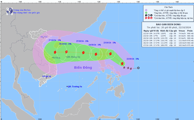
Forecasting the track and intensity of Typhoon Kristine, PAGASA noted that the storm near the South China Sea is expected to move northwest to west-northwest until October 24 before turning westward for the remainder of the forecast period.
According to forecasts, Typhoon Kristine may make landfall in Isabela, Philippines on the evening of October 23 and may then leave the Philippine forecast area (PAR) on the evening of October 25.
PAGASA forecasters do not rule out the possibility of changes in the forecast track of the latest storm near the South China Sea, depending on the movement of weather systems surrounding the tropical storm in the next few days.
In terms of intensity, Typhoon Kristine is expected to remain a tropical storm for the next 24 hours. The latest storm could reach severe tropical storm strength on October 23 and could make landfall in Isabela, Philippines as a severe tropical storm.
Storm No. 11 Kristine is forecast to reach typhoon level on October 25 when it enters the East Sea.
Philippine weather experts note that this tropical storm is still over the Philippine Sea, so the possibility of the storm rapidly intensifying due to favorable environmental conditions cannot be ruled out.
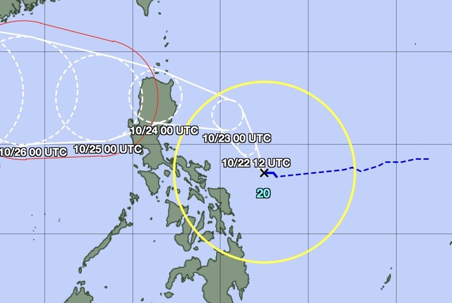
Forecast, at 2:00 p.m. on October 22, the storm is 390 km east of Daet, Camarines Norte, Philippines.
The storm moved over the next 24 hours and was 145 km east of Casiguran, Aurora at 2:00 p.m. on October 23.
Typhoon Kristine is expected to be over the coastal waters of Candon, Ilocos Sur at 2:00 p.m. on October 24.
At 2:00 a.m. on October 25, Typhoon No. 11 Kristine will be southwest of Sinait, Ilocos Sur.
By 2 a.m. on October 26, the latest storm Kristine will move outside the Philippine PAR forecast area, 505 km west of Sinait, Ilocos Sur.
At the end of the forecast period of the Philippine weather agency PAGASA, at 2:00 a.m. on October 27, Typhoon Kristine was in the East Sea, 895 km from Northern Luzon.