The latest storm news on the morning of July 8 from the Joint Typhoon Warning Center (JTWC) of the US Navy said that after completing the cycle of replacing as a storm eye on July 7, Super Typhoon Ba Vi continued to strengthen and is returning to intensity level 5 on the US scale.
According to the Japan Meteorological Agency (JMA), the strong wind area of Super Typhoon Ba Vi extends about 1,300km in diameter, making Ba Vi the largest tropical storm in the western Pacific basin since Typhoon Krosa in 2025.
Environmental conditions are still favorable to maintain the intensity of the super typhoon in the next 24 hours. Starting from the end of July 9, strong gusts are expected to gradually disrupt the system, causing Super Typhoon Ba Vi to likely begin a weakening trend and will continue this trend until the typhoon makes landfall on the east coast of China this weekend.
According to the latest storm news from the Philippine Atmospheric, Geophysical and Astronomical Services Administration (PAGASA) on the morning of July 8, Super Typhoon Ba Vi (Philippines name is Inday) is currently located in the Philippine Area of Responsibility (PAR).
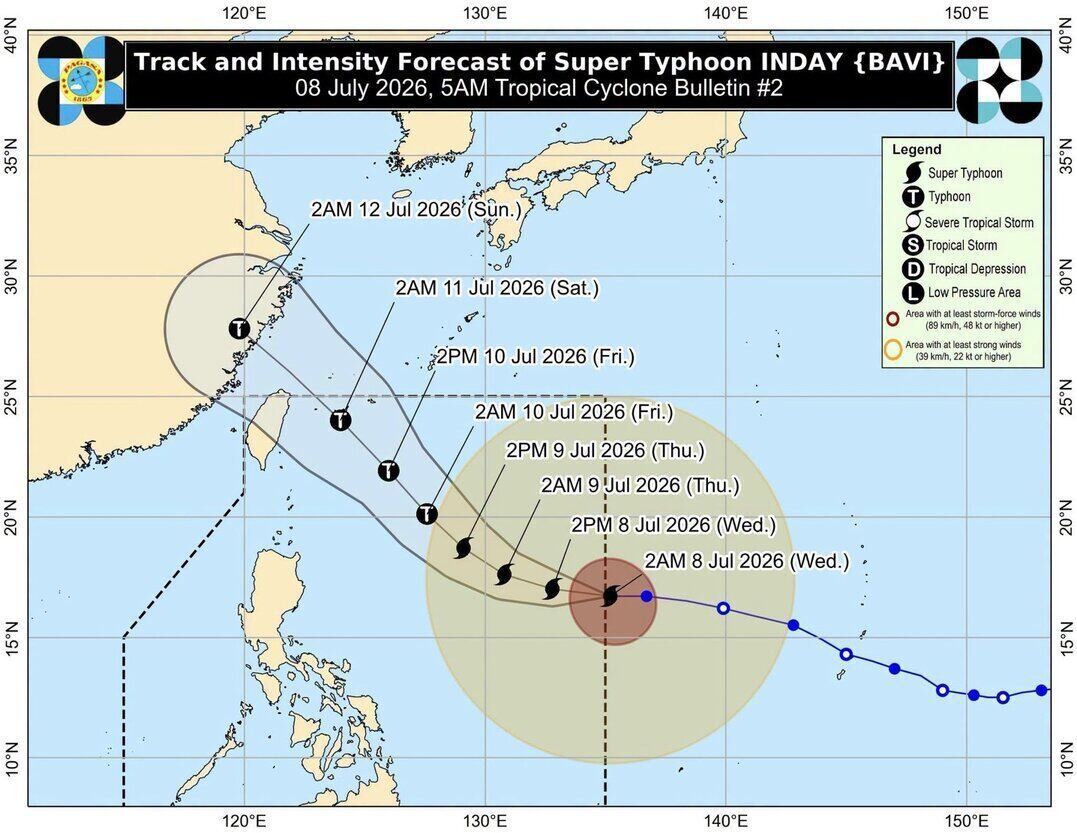
Super typhoon Ba Vi's eye is 1,405km east of Northern Luzon, Philippines. The latest super typhoon of the 2026 typhoon season is moving west at a speed of 25 km/h, with maximum sustained winds of 185 km/h near the eye and gusts up to 230 km/h.
The super typhoon is in PAR and is forecast to continue moving westward in the next 24 hours. After that, Ba Vi will shift direction to the northwest while still located in the Philippine Sea and may get closest to the northernmost part of Luzon on July 10 before heading towards the southern islands of Japan and the waters north of Taiwan (China).
Super typhoon Ba Vi is forecast to leave the Philippine forecast area on July 11 and make landfall on the east coast of mainland China on July 12.
Philippine typhoon forecasters said that Ba Vi will maintain the strength of the super typhoon until July 9 and will weaken into a typhoon in the afternoon or evening of the same day. After that, this typhoon will gradually weaken but is still likely to maintain its typhoon intensity throughout the remaining forecast period.