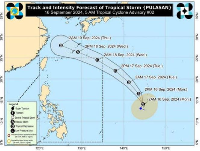
According to the latest storm information from the US Navy's Joint Typhoon Warning Center (JTWC), Typhoon Pulasan (Japan's Typhoon No. 14) is located 1,637 km southeast of Kadena Air Base and has been moving north-northwest at a speed of 19 km/h over the past 6 hours.
JTWC forecasts Typhoon Pulasan's track to move northwest into the East China Sea over the next 36 to 48 hours during the forecast period.
The latest storm in the Pacific is expected to pass 37 kilometers south of Okinawa within 36 to 48 hours.
During this period, Pulasan is expected to have difficulty strengthening as an upper-level low pressure area in the northwest is significantly affecting the storm.
After 2 days, the track through the East China Sea is expected to bring Typhoon Pulasan to mainland China in the next 3 days, after which the storm will quickly dissipate over land.
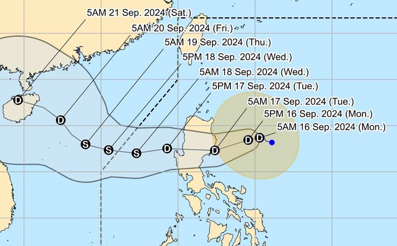
According to the latest typhoon forecast from the Philippine weather agency (PAGASA), typhoon Pulasan remains strong as it continues to move west-northwest.
At 10 p.m. on September 16, Typhoon Pulasan was centered approximately 2,015 kilometers east of Central Luzon, Philippines, outside the Philippines' forecast area. Maximum sustained winds near the storm's center were 65 kilometers per hour, with gusts of up to 80 kilometers per hour. The area affected by Typhoon Pulasan's strong winds extended 650 kilometers from the storm's center.
Xinhua's latest storm news said that on September 16, Fujian province, eastern China, activated a level 4 emergency response due to the possibility of wind, rain and high waves caused by Typhoon Pulasan, the 14th storm this year.
According to Chinese weather forecasters, Typhoon Pulasan may have a similar movement direction as Bebinca, but due to the impact of cold air from September 18 to 20, the new storm's movement will be difficult to predict.
Earlier, Typhoon Bebinca, the 13th storm of this year's Pacific typhoon season, hit Shanghai on the morning of September 16, causing gusts of wind and heavy rain in the eastern Chinese megacity.
According to the latest storm news from Taiwan News, typhoon Pulasan is forecast to have a similar path to typhoon Bebinca.
At 2 a.m. on September 16, Pulasan was located 2,650 kilometers east-southeast of Eluanbi, the southernmost tip of Taiwan, according to Taiwan's CWA. Pulasan is expected to make its closest approach to Taiwan on August 19.
Typhoon forecaster Lin Te-en of National Taiwan University said Pulasan's projected path is similar to Bebinca's. The storm is expected to pass Naha, Okinawa on September 18 and make landfall in central China on September 19. He predicted that Pulasan's expected intensity will be mild.
Taiwanese (Chinese) typhoon forecasters said Pulasan is a small tropical storm but moves quickly and has a clear direction.
Although the storm near the East Sea Pulasan will not directly affect Taiwan (China), if the storm's track shifts 200km to 300km south or if the storm's radius expands beyond 150km, the No. 14 storm could enter waters off northern Taiwan, forecaster Lin Te-en noted.