The Philippine Atmospheric, Geophysical and Astronomical Services Administration (PAGASA) storm forecast said that the eastern low pressure system Aurora has strengthened into tropical depression Gener.
At 8:00 a.m. on September 16, the center of the tropical depression was at about 17.0 degrees north latitude, 125.0 degrees east longitude, about 315km east-northeast of Casiguran, Aurora, Philippines.
Winds near the center of the tropical depression are strong at 55 km/h, gusting to 70 km/h. The storm moves slowly in a west-southwest direction. Strong winds extend up to 360 km from the center of the tropical depression.
PAGASA forecasts moderate seas with waves ranging from 1.5 to 3.5 meters high in the coasts of Northern Luzon, Central Luzon and the east coast of Southern Luzon in the next 24 hours.
Moderate seas with 2.5m waves in the remaining coasts of the Philippines outside the typhoon warning area.
Tropical Depression Gener is expected to move mainly west to west-southwest until the afternoon of September 18 before turning west-northwest to northwest for the remainder of the forecast period. Gener is expected to make landfall over Isabela or Aurora in the Philippines within the next 24 hours.
According to the forecast track, the tropical depression may leave the Philippine PAR forecast area on September 18, entering the East Sea, expected to make landfall on Hainan Island, China from late Friday night (September 20) to early Saturday morning (September 21).
Gener is likely to strengthen over the next two days but is expected to reach tropical storm status on Wednesday (September 18) after entering the South China Sea.
Gener is forecast to maintain tropical storm intensity and weaken into a tropical depression before making landfall in Hainan, China. Due to its proximity to the Luzon landmass, the tropical depression's intensity and track are likely to change as it passes over Luzon.
The Japan Meteorological Agency (JMA) said that the path of this tropical depression is quite similar to the path of storm No. 3 Yagi into the East Sea, also passing through the northern Philippines, passing through China's Hainan Island and into the Gulf of Tonkin.
According to JMA forecast, Gener will enter the Gulf of Tonkin on September 21 with winds of 72 km/h, gusts of 108 km/h.
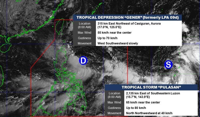
Also on September 16, PAGASA is monitoring storm Pulasan about 2,215km east of Southeast Luzon.
Maximum sustained winds near the center of the storm were 65 km/h, gusting to 80 km/h, and the central pressure was 998 hPa. The storm was moving north-northeast at 20 km/h. Strong to gusty winds extended out to 380 km from the center of the storm.
With a similar track to Typhoon Bebinca, the current track scenario suggests that Typhoon Pulasan will not directly impact any part of the Philippines during the forecast period.


