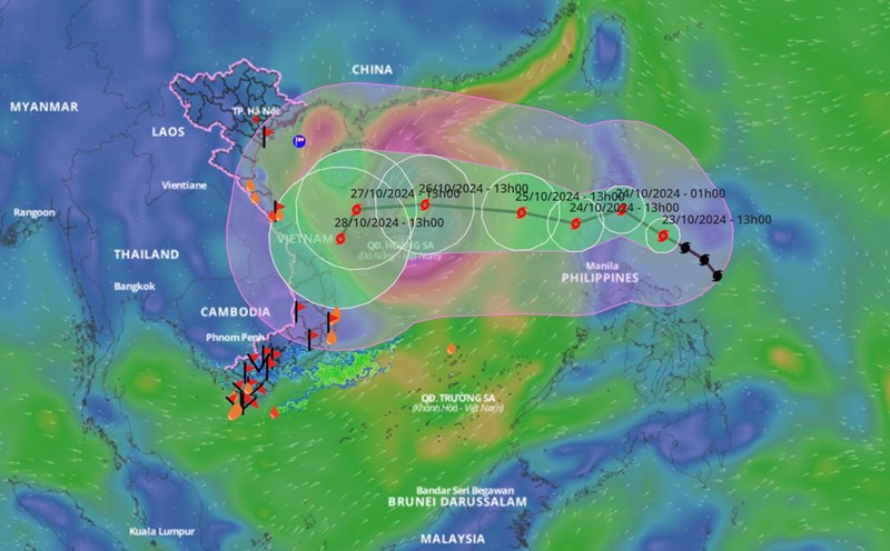
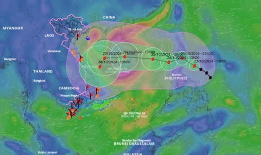
Forecast of storm Tra Mi intensity when entering the East Sea
NHÓM PV |
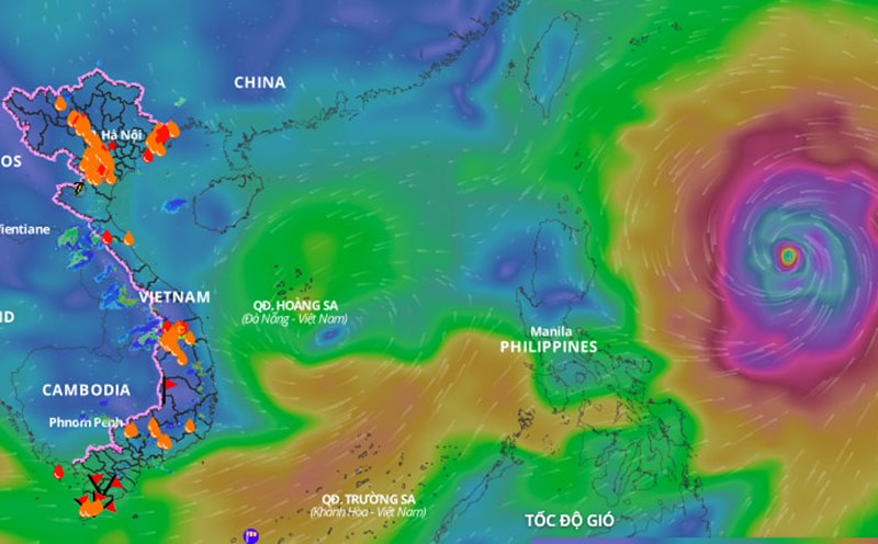
Forecast in the next 24 hours, when entering the East Sea, the strongest wind near the center of storm Tra Mi is level 9 - 10, gusting to level 12.
NHÓM PV |
Forecast in the next 24 hours, when entering the East Sea, the strongest wind near the center of storm Tra Mi is level 9 - 10, gusting to level 12.
|
The meteorological agency has provided some forecast information on rain developments and storm/tropical depression activity from now until November 20.
|
Storm Tra Mi is currently at level 9, moving northwest. The storm is likely to change direction and intensify.
|
Hanoi - The journey to find the identity of martyrs through DNA testing is gradually reconnecting the unfinished memories of martyrs' families.
|
Ho Chi Minh City - Functional agencies are clarifying the case of Mr. H.B.L writing a suicide note about buying land overlapping the boundary, then falling into a deadlock and suspected suicide.
|
Live football match Indonesia vs Cambodia in Group A ASEAN Cup 2026 at 8:30 PM on July 27.
|
Talking to Lao Dong Newspaper on the afternoon of July 27, former Miss Dieu Van said that she still keeps the crown that was once announced to be worth 3 billion VND as evidence that it is... fake.
|
Ho Chi Minh City - With 3 steel overpasses expected to be additionally invested, 3 Thang 2 road will have a total of 5 overpasses on a length of only about 5km.

NHÓM PV |
The meteorological agency has provided some forecast information on rain developments and storm/tropical depression activity from now until November 20.

NHÓM PV |
Theo cơ quan khí tượng, bão Trà Mi sẽ đi vào Biển Đông trong 24 giờ tới và tiếp tục mạnh lên, khả năng đổi hướng.
AN AN |
Storm Tra Mi is currently at level 9, moving northwest. The storm is likely to change direction and intensify.
Editorial: (+84 24) 38252441 - 35330305
Electronic newspaper: (+84 24) 38303044
Hotline: 096 8383388
Readers: (+84 24) 35335235
Email: toasoan@laodong.com.vn
Print: (+84 24) 39232694 - E-newspaper: (+84 24) 35335237
Address: No. 06, Pham Van Bach street, Cau Giay ward, Ha Noi.
Giấy phép số: 2013/GP-BTTT
Do Bộ TTTT cấp ngày 30.10.2012
Xuất bản số Báo Lao Động đầu tiên vào ngày 14.8.1929
Advertising revenue supports our journalism and helps keep our content free for everyone. Please consider disabling your ad blocker to support our work.
Thực hiện theo các bước sau để tắt tiện ích chặn quảng cáo