Tropical depression is about to weaken
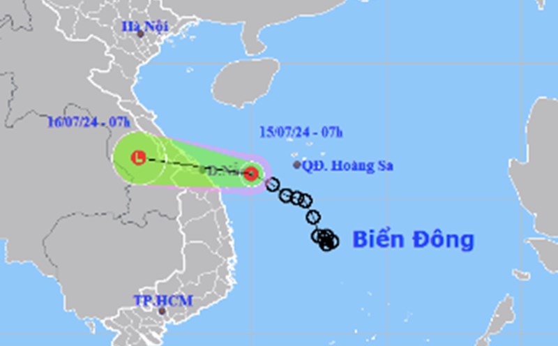
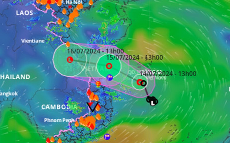
At 7:00 a.m. on July 15, the center of the tropical storm was at 15.9 degrees North latitude; 110.0 degrees East Longitude, in the west-southwest sea of the Hoang Sa archipelago with wind strength of level 6, gusts of level 8.
Danger zone in the East Sea in the next 24 hours: From latitude 14.5-17.0 degrees VB; West of longitude 111.0 degrees KD.
It is forecast that in the next 24 hours, tropical depression will gradually weaken into a low pressure area in the southern Laos area.
Information from the Department of Dyke Management and Natural Disaster Prevention and Control, from July 15-17, the North and Central Central regions had a common rain of 70-150mm, locally over 250mm; The Northern Delta and coastal areas, the Central Highlands and the South are commonly 50-100mm, locally over 200mm.
From the beginning of July to July 13, 2024, the northern mountainous provinces locally had heavy to very heavy rain, of which Ha Giang had rain from 400-600mm, Tan Lap station (Bac Quang) had 1,568mm and had very high intensity. 507mm/12 hours (from 7:00 p.m. on July 9 to 7:00 a.m. on July 10); The Northern Delta rains 100-200mm. Heavy rain caused a landslide on July 13 on Highway 34, Bac Me district, killing 11 people and injuring 4 people.
On rivers from Thanh Hoa - Quang Tri, there is a possibility of a flood on small rivers and streams, upstream rivers at alert level 1 (BD1), downstream at alert level 1; High risk of flash floods, landslides in mountainous areas, local flooding in low-lying riverside areas and urban areas.
Regarding the situation of hydroelectric reservoirs in the Red River basin, at 8:00 a.m. on July 15, the water levels upstream of the lakes and the highest water levels before the flood (early flood period) were as follows: Son La: 203.05m/200.0m (higher than 3.05m); Hoa Binh: 108.56m/105.0m (higher than 3.56m); Tuyen Quang: 109.33m/105.2m (higher than 4.13m).
By July 20, 2024, the lakes must be operated to the highest water level before the flood (main flood period) as follows: Son La: 197.3m (higher than 5.75m); Hoa Binh: 101m (higher than 7.56m); Tuyen Quang: 105.2m (higher than 4.13m).
Regarding the situation of Northern irrigation reservoirs: There are a total of 2,543 reservoirs, with capacity reaching 61-95% of design capacity; There are currently 120 damaged and degraded reservoirs and 77 reservoirs under construction.
Regarding the situation of irrigation reservoirs in the North Central region: There are a total of 2,323 reservoirs, with capacity reaching 44-56% of design capacity; There are currently 141 damaged and degraded reservoirs and 63 reservoirs under construction.
According to the National Center for Hydro-Meteorological Forecasting, on the mainland, from July 15 to July 17, the Northern Delta, Central Highlands and Southern regions; The North and Central Central regions have showers and thunderstorms; Locally there is heavy to very heavy rain .
Remedial work
The Prime Minister issued Official Telegram No. 67/CD-TTg dated July 13, 2024 directing the recovery of landslides in Ha Giang province and responding to floods and landslides.
The Ministry of Agriculture and Rural Development issued 3 telegrams and documents directing response to tropical storms, strong winds at sea and widespread heavy rain (Dispatch No. 4978/CD-BNN-DD dated July 13; Document No. 4915/BNN-DD dated July 11 and No. 4972/BNN-DD dated July 12, 2024); sent a Working Group to coordinate and direct the response and overcome the consequences of landslides in Bac Me district, Ha Giang province.
The Ministries of National Defense, Public Security, Transport, and Industry and Trade have issued telegrams directing the recovery of consequences in Ha Giang and responding to tropical depression and floods.
The National Center for Hydro-Meteorological Forecasting early identifies and regularly provides forecasts of tropical depression and heavy rain to serve response direction.