Phu Tho forecasts some places to have over 100 mm of rain
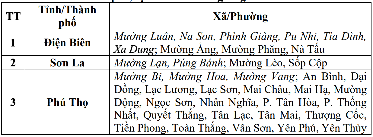
According to the National Center for Hydro-Meteorological Forecasting, in the past 18 hours (from 9:00 p.m. on July 31 to 3:00 p.m. on August 1), the areas of Dien Bien and Son La provinces have had moderate to heavy rain.
In the past 2 hours (from 1:00 p.m. to 3:00 p.m. on August 1), Phu Tho province has had moderate to heavy rain. Soil moisture models show that some areas in the above provinces are nearly saturated (over 85%) or have reached a saturated state.
In the next 3 - 6 hours (from 3:30 p.m. on August 1), the above provinces will continue to have rain with common accumulated rainfall in Dien Bien of about 10mm, some places over 20mm; Son La 10 - 30mm, some places over 50mm; Phu Tho 30 - 60mm, some places over 100mm.
In the next 6 hours (from 3:30 p.m. on August 1), there is a risk of flash floods on small rivers and streams, landslides on steep slopes in many communes/wards.
The meteorological agency warns that the risk of natural disasters due to flash floods, landslides, and land subsidence due to heavy rain or water flow is level 1.
Flash floods and landslides can have serious impacts on the environment, threaten people's lives; cause local traffic congestion, affect the movement of vehicles; civil works and economic infrastructure, causing damage to production activities and social life.
The meteorological agency recommends that localities proactively review flow bottlenecks and vulnerable areas to take timely preventive and response measures.
Floods on the Ma River in Thanh Hoa rise rapidly
Regarding the hydrological situation, the flood in the upper reaches of the Ma River is currently rising rapidly. At 4:00 p.m. on August 1, the water level on the Ma River at Muong Lat station was 169.34m, about 0.66m below alert level 1; at mid-stream and downstream stations, it was still below alert level 1.
From this afternoon, August 1 to August 3, a flood will occur in the central and downstream areas of the Ma River. During this flood, the upstream water level at Muong Lat station is likely to rise to alert level 3; at midstream stations, it will rise to alert level 1 - alert level 2, some places above alert level 2; at downstream stations, it will rise to alert level 1 and above alert level 1, especially at Giang station, it will still be below alert level 1.
High risk of flooding in areas along rivers and streams along the central and upper reaches of the Ma River. In addition, there is a high risk of flash floods on small rivers and streams and landslides on steep slopes in mountainous areas of Thanh Hoa province.
Real-time warning information for areas at risk of flash floods and landslides is provided online on the website of the Department of Hydrometeorology at: https://luquetsatlo.nchmf.gov.vn and in a separate bulletin warning of flash floods and landslides.
The meteorological agency warns that the risk of natural disasters due to floods is level 2. Floods on rivers and streams can cause flooding in low-lying areas along rivers, affecting activities such as waterway transportation, aquaculture, agricultural production, people's livelihood and socio-economic activities.


