Vingroup Group has just sent a document to departments, boards, branches and People's Committees of Tam Thang, Rach Dua, Vung Tau wards to collect comments on the partial adjustment project of the General Plan of Vung Tau City (old) to 2035 at a scale of 1/10,000.
Previously, the Standing Committee of the Ho Chi Minh City Party Committee had agreed on the investment policy for the Can Gio - Vung Tau sea-crossing road project, and at the same time approved the adjustment of related plans as a basis for implementation.
The Ho Chi Minh City People's Committee then assigned Vingroup Group to develop a project to partially adjust the General Plan of Vung Tau City (old) according to Resolution 260 (amending and supplementing Resolution 98) of the National Assembly on specific mechanisms for city development.
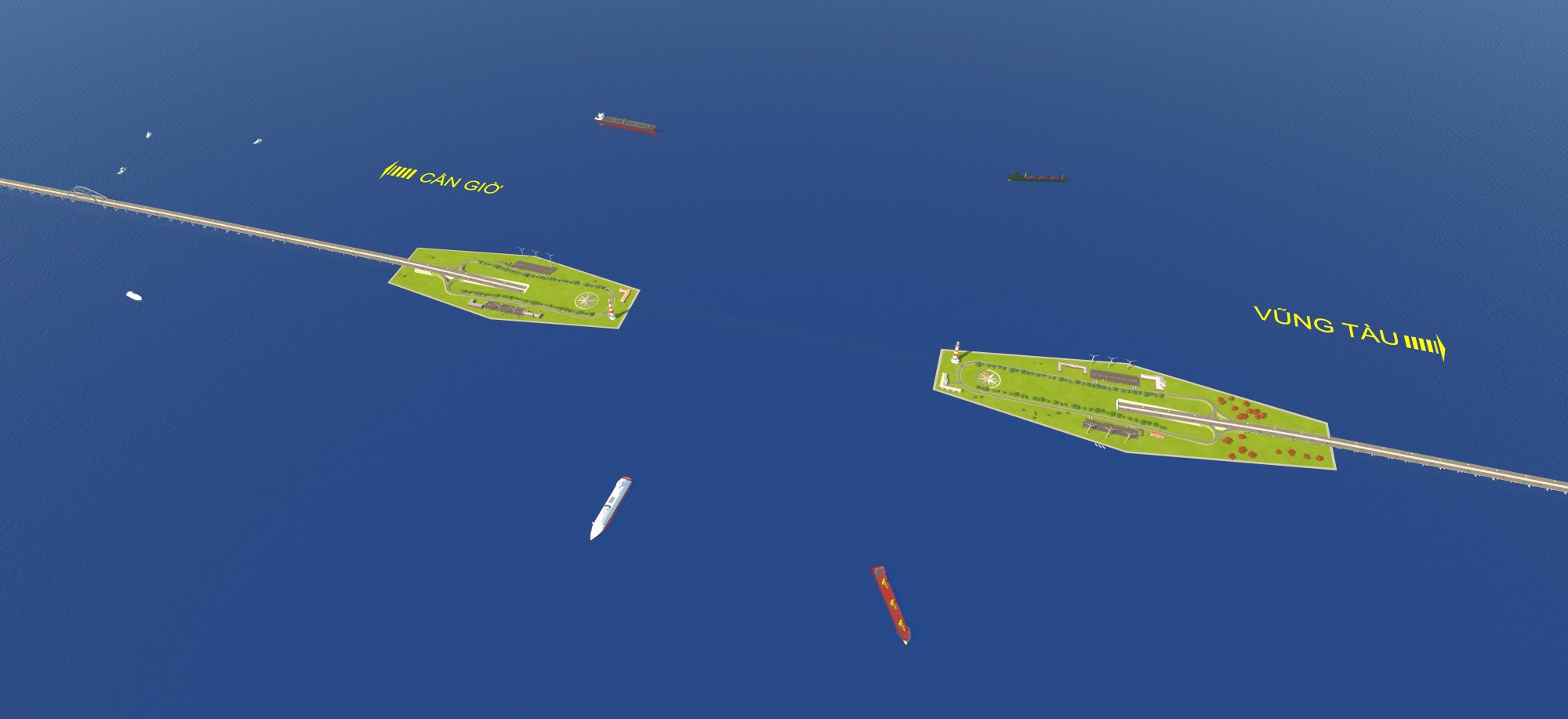
According to the proposal, the sea-crossing road connecting Can Gio - Vung Tau has a total length of about 14 km, with a scale of 6-8 lanes.
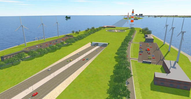
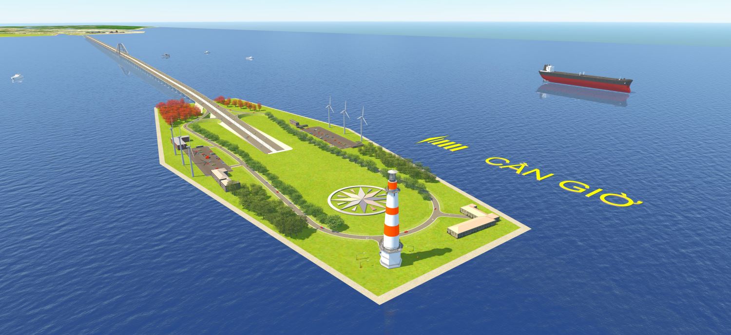
The project combines both a bridge and a sea tunnel. In which, the tunnel item is about 3.1 km long, with a scale of 6 lanes, using a reinforced concrete submersible tunnel structure similar to Thu Thiem tunnel. Two artificial islands will be built at both ends of the tunnel to serve engineering and exploitation.
The sea bridge section is about 8 km long. The access road connecting both ends of the project is nearly 3 km long.
The total estimated investment is more than 92,600 billion VND, implemented in BT form. The project is expected to start construction in 2026 and be completed in 2029.
The local adjustment plan of the General Plan of Vung Tau City (old) will update the sea-crossing road, connecting with Sao Mai road running along Rach Dua ward industrial park section on land according to the North Vung Tau sub-area plan.
At the same time, adjust the branch line of the freight railway and the location of the freight station to Sao Mai - Ben Dinh industrial park to the west adjacent to Ghenh Rai Bay; update residential land plots, mixed urban land and national defense land according to the approved zoning plan.
Mai Sao - Ben Dinh road has also been adjusted in cross-section with a total width of 90 m, including main roads, parallel roads, green strips, and sidewalks.
In addition, technical infrastructure systems such as electricity supply, water supply, and wastewater drainage are also synchronously adjusted.
According to assessments, the addition of a sea-crossing route brings clear efficiency in trade and service development. The new transportation route helps shorten travel time between Ho Chi Minh City and the Southeast coastal area, reduce logistics costs, and improve the efficiency of goods circulation.
The project also creates conditions for the formation of service, logistics and commercial centers at urban gateways, contributing to expanding the marine economic space and attracting investment.
In the tourism sector, the sea-crossing route will form a strategic connecting axis between Ho Chi Minh City and coastal destinations such as Can Gio and Vung Tau.
Convenient access helps develop a variety of types such as marine tourism, mangrove ecotourism, high-class resorts and short-day tourism. Thereby, extending the length of stay and increasing tourist spending.
Regarding urban development, the road plays a backbone role, promoting the formation of urban areas, services - tourism and mixed functional areas along the coast. This contributes to population expansion, re-arrangement of urban space, improving land use value, and increasing budget revenue from land.
The project also helps to complete the external transport network, strengthen links between Ho Chi Minh City and the Ba Ria - Vung Tau region, and reduce pressure on existing routes.


