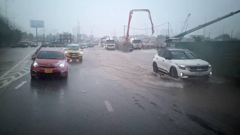
On the afternoon of October 4, Lao Dong reported that prolonged rain caused flooding and traffic jams in some areas of Thu Duc City such as Luong Dinh Cua, the road leading to the Ho Chi Minh City - Long Thanh - Dau Giay highway...
Satellite cloud images, weather radar images and lightning locators show that thunderstorms are developing and causing rain with thunderstorms and lightning in District 6, District 11, Tan Phu, and Binh Chanh.
In addition, thunderstorms in the Ba Ria - Vung Tau and Dong Nai areas are also tending to expand and move towards Ho Chi Minh City.
In the next 0 - 3 hours, thunderstorms will continue to develop, causing showers, accompanied by thunderstorms and lightning for the above districts, then expanding to other neighboring areas.
Rainfall is generally from 2-10mm, some places over 10mm. During thunderstorms, beware of tornadoes, hail and strong gusts of wind around level 5-7 (8-17m/s), heavy rain causing localized flooding.
The thunderstorms are caused by stable continental cold high pressure. A low pressure trough forms with an axis at about 6-9 degrees North latitude. High-altitude easterly wind disturbances have a weak impact on the weather in the Southern region.
In the next 24-48 hours, the continental cold high pressure will weaken and move eastward. Forming an equatorial low pressure trough with an axis of about 4-8 degrees North latitude. Above, the subtropical high pressure will lift its axis northward through the North.
In the Southern sea areas, the wind direction is East to Northeast and operates with weak intensity.
From 72 hours to the 10th day, the continental cold high pressure will strengthen and weaken again, then weaken and move to the East from October 9-10. The equatorial low pressure trough tends to lift its axis to the North through the South and South Central regions, and gradually weakens around October 11-12.
Above, the subtropical high pressure has an axis over the North, from October 7 it weakened, until about October 11-12, the subtropical high pressure became active again, the southern branch has an axis over the South. In the sea areas of the South, the East to Northeast wind has weak intensity.
Therefore, in the coming days, rain will continue to increase in the Southern region. During thunderstorms, there is a possibility of tornadoes, lightning and strong gusts of wind. Beware of the possibility of heavy rain causing localized flooding in low-lying areas and areas with poor drainage capacity.


