The Ho Chi Minh City Department of Public Transport has just sent a document to the Ho Chi Minh City Department of Construction and a consulting consortium to prepare a project to adjust the general planning of Ho Chi Minh City to 2040, with a vision to 2060, for the southern coastal route of the Ho Chi Minh City area.
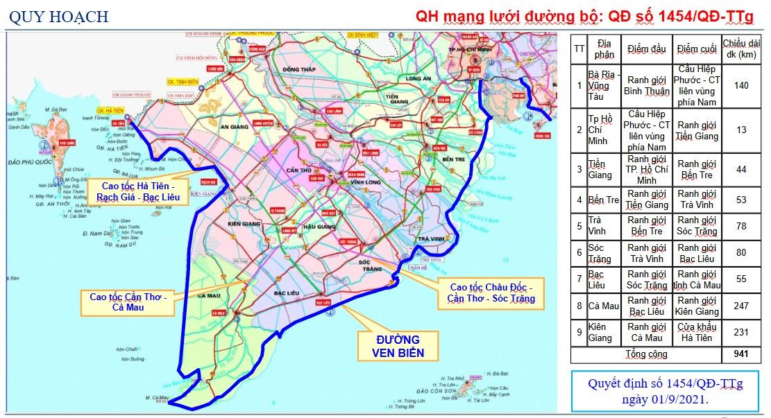
According to Decision 1454/QD-TTg of the Prime Minister on road network planning for the period 2021-2030, with a vision to 2050, the coastal route has been identified as an important traffic axis, connecting Ho Chi Minh City with the Mekong Delta.
This route is 941km long, passing through 9 provinces and cities including: Ba Ria - Vung Tau, Ho Chi Minh City, Tien Giang, Ben Tre, Tra Vinh, Soc Trang, Bac Lieu, Ca Mau and Kien Giang.
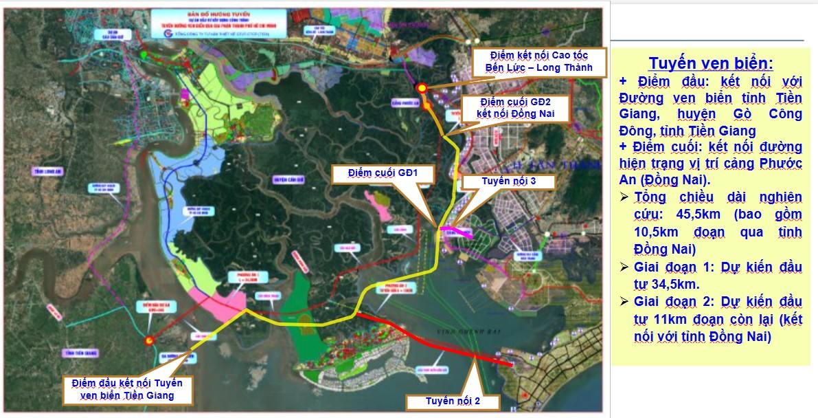
According to the Ho Chi Minh City planning for the period 2021 - 2030, with a vision to 2050, the city has identified a southern coastal route connecting from Tien Giang through Can Gio district (Ho Chi Minh City) to Dong Nai and Ba Ria - Vung Tau.
This route will start from National Highway 50 (Tien Giang), cross the Soai Rap River to Can Gio District (HCMC), connect with Can Gio International Transit Port, Phuoc An Port and extend to Ben Luc - Long Thanh Expressway (Dong Nai).
The total length of the route is about 45.5km (including 10.5km through Dong Nai province), with a cross-section of 50m wide, including 8 lanes.
In the immediate future, phase 1 proposes to invest in two parallel roads, each side includes 2 lanes.
The Ho Chi Minh City Department of Public Transport has coordinated with the Transport Design Consulting Corporation - JSC (TEDI) to prepare 3 investment options for the southern coastal route in Ho Chi Minh City.
Option 1: Phase 1 with a total investment of VND 31,556 billion. Phase 2 (8 lanes complete) has a total investment of about VND6,400 billion. This is an option recommended by a consultant.
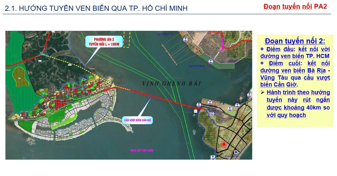
Option 2: Phase 1 invests in the main route and road connecting to the Ba Ria - Vung Tau coastal road via the Can Gio overpass.
This option helps shorten the journey by about 40km compared to the original plan but the total capital is more than 55,800 billion VND. The total investment in phase 2 is about VND6,400 billion. The total investment for both phases is up to VND 62,231 billion.
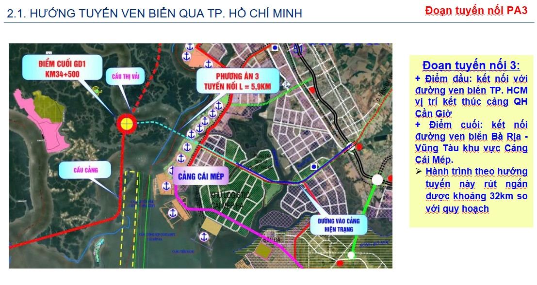
Option 3: Phase 1 to invest in the main route and road to Cai Mep port. This route helps shorten the journey by about 32 km compared to the original plan, with a total capital of nearly VND35,400 billion. Phase 2 is 6,400 billion VND. The total investment for both phases is 42,275 billion VND.
The Ho Chi Minh City Department of Public Transport said it will work with the provinces of Dong Nai, Tien Giang, Ba Ria - Vung Tau to agree on the location of the unit and related contents.
This is the basis for updating the southern coastal route into the project to adjust the general planning of Ho Chi Minh City to 2040, with a vision to 2060 and the general planning projects of the relevant provinces.
In addition to the section through Ho Chi Minh City, the Ba Ria - Vung Tau coastal route is being implemented with a length of nearly 78km, 6-8 lanes wide, connecting Cai Mep - Thi Vai port with Binh Chau. The project has a total capital of more than 7,000 billion VND, and started construction on June 17, 2023, expected to be completed in the third quarter of 2025.
The coastal route through Tien Giang is about 31km long, connecting with provincial road 871B (about 6km from National Highway 50) in Gia Thuan commune, Go Cong Dong district and ending at the bridge over Cua Dai river, Phu Tan commune, Tan Phu Dong district.
The project has a total investment of about VND 5,591 billion and is being proposed for approval from the Asian Development Bank (ADB).


