According to the latest storm information from the Joint Typhoon Warning Center (JWTC), Typhoon Bakung is moving slowly at a speed of about 9 km/h in the West Southwest direction.
In the storm-affected waters, wave heights can reach up to 7 meters, endangering maritime activities and marine tourism.
Typhoon Bakung formed from a low pressure area appearing in the South Indian Ocean on December 12, then quickly strengthened into a tropical storm in less than 24 hours.
The strongest winds near the center quickly accelerated from 75 km/h to 130 km/h within 48 hours.
Over the past few days, Typhoon Bakung has maintained its southwestward direction, but is showing signs of slowing as the surrounding atmospheric conditions change.
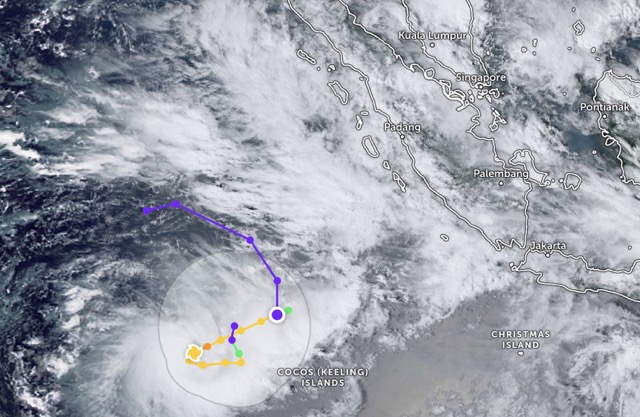
It is forecasted that in the next 12 hours, the storm will move very slowly before likely changing direction, moving east, then north in the following days. The storm's path is still uncertain as forecast models are not yet consistent.
Typhoon Bakung reached its peak intensity on December 14 (local time), with the strongest winds near the center reaching about 140 km/h.
The storm is expected to gradually weaken over the next few days as wind shear increases and dry air flows in.
However, by the end of the forecast period, when the storm moves north and encounters a more favorable environment, the possibility of a recovery is not ruled out.
The storm is active near the Invest 92S depression. The Invest 92S depression is currently located near the Cocos (Keeling) archipelago in the South Indian Ocean. This low pressure is assessed to have a low chance of developing into a tropical depression in the next 24 hours. The forecast track of the depression is expected to tend to approach Typhoon Bakung.
Due to its small scale, Typhoon Bakung can change its intensity rapidly in a short time, making forecasting difficult. International meteorological agencies currently assess the reliability of the trajectory as low, while the trend of weak intensity is considered more certain.
Tourists planning or staying in areas in and around the South Indian Ocean, especially the waters around Cocos Islands and shipping routes in the region, should closely monitor official warnings. Limit or postpone sea tourism activities, boats, diving and waterway travel when big waves and bad weather continue.
Tourists traveling by cruise ship or tourist ship should strictly follow the instructions of the authorities and service operators.
For coastal destinations on Cocos and Christmas Island - the overseas territory of Australia and the East Java, Bali and West Nusa Tenggara (Indonesia), tourists need to prepare safety plans, avoid areas with big waves, strong winds and unstable weather during the complicated storms.


