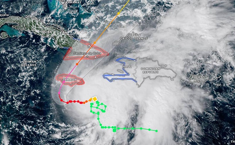
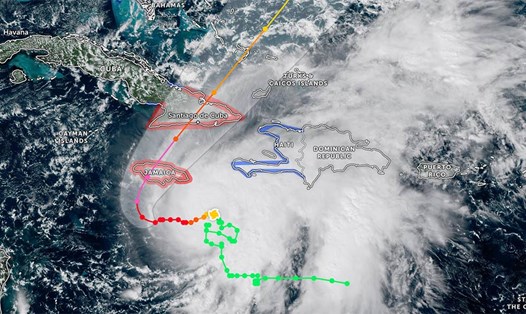
Superstorm Melissa is the worst storm in Jamaica's history. Rain bands and strong winds at the edge of the storm are sweeping across the island nation of Jamaica, causing heavy rain and strong gusts of wind.
Authorities have issued mandatory evacuations in vulnerable coastal areas ahead of the storm's landfall on Tuesday morning (local time).
The US National Hurricane Center (NHC) warned that superstorm Melissa could bring up to 1,000 mm of rain, water rise more than 4 meters and sustained winds of 260 km/h, threatening serious damage to infrastructure and isolating many communities.
The eye of a round storm about 18 km wide, surrounded by a thick convective cloud belt, may be undergoing a replacement cycle into a new eye - a sign that the intensity of the storm is still fluctuating.
The center of the storm is forecast to pass through Jamaica today, sweeping across eastern Cuba on the morning of October 29, continuing towards the Bahamas in the evening of the same day and approaching Bermuda on the night of October 30 or the morning of October 31.
After that, Melissa is likely to gradually weaken and become a tropical depression in the North Atlantic.
So far, natural disasters have killed at least seven people in Haiti, Jamaica and the Dominican Republic, although the super typhoon has yet to make landfall.
Although super typhoon Melissa's winds are strong, the risk of flooding and landslides is the top threat. Jamaica is forecast to see 500-750 mm of rainfall, with some places exceeding 1,000 mm in the eastern mountainous areas, causing severe flash floods and landslides. Southern Haiti could see up to 300 mm of rain, while eastern Cuba will see some places reach 600 mm.
In addition to heavy rains, waves as high as 4 meters along the southern coast of Jamaica could sweep inland, cutting off many residential areas.
In the area near the center of the storm, there is a risk of the entire construction collapsing. The southern coast, high waves and dangerous rising water will continue throughout the day, which could cause casualties if evacuation instructions are not followed.
Currently, authorities of countries in the Caribbean are urgently evacuating people, opening shelters, and temporarily suspending aviation and tourism operations until the storm subsidizes.
Recommendations for tourists ahead of super typhoon Melissa
Avoid traveling to islands in the Caribbean until the end of this week.
Continuously monitoring announcements from authorities and airlines.
If you are in the affected area, stay in a safe shelter, prepare water, food and spare batteries for the next few days.