According to the latest storm information from the US National Hurricane Center (NHC), Shelter is currently reaching winds of nearly 260 km/h, with the highest intensity of level 5 on the Saffir-Simpson scale.
The latest data from the US Air Force's hurricane reconnaissance aircraft shows maximum winds at the center of the storm reaching 280 km/h, confirming that Shelter has reached Category 5 - the highest level on the tropical storm scale, equivalent to super typhoon level.
Shelter is currently moving slowly west-northwest at a speed of about 8 km/h and is expected to make landfall on the southern shore of Jamaica on Tuesday morning (28.10), then cross the northern shore of the island in the afternoon of the same day, local time.
The storm will then move northeast, affecting eastern Cuba, the Bahamas and near Bermuda in the coming days.
In the next 12-24 hours, the storm may continue to strengthen as it passes through the sea with high temperatures and weak wind shear. However, the intensity may fluctuate.
Whether Melissa makes landfall at level 4 or level 5, wind damage is forecast to be catastrophic, especially in the Jamaica mountainous area.
After sweeping through Jamaica, the storm may weaken but still maintain strong intensity as it approaches Cuba, the Bahamas and the area near Bermuda.
The super typhoon is seriously threatening the Caribbean, especially Jamaica, Haiti, the Dominican Republic, Eastern Cuba, the southeastern Bahamas and the Turks and Caicos Islands.
In Jamaica, authorities have advised residents and visitors to absolutely not leave safe havens.
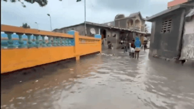
Weather forecast for today (October 27) to the end of Tuesday (October 28, local time), this area is likely to experience flash floods and serious landslides, causing great damage to people and property.
The forecast of strong winds of destruction, especially in mountainous areas, will start from tonight, October 27 (local time), which can destroy infrastructure, cause widespread power outages and communication, and isolate many residential areas.
Additionally, life-threatening storm surge and high waves are warned along the southern coast of Jamaica.
In Haiti and the Dominican Republic, very heavy rains could cause flash floods and serious landslides in southwestern Haiti and the southern Dominican Republic in the next few days.
In Haiti, many areas are at risk of severe infrastructure damage and are isolated. The area is expected to be affected by strong tropical storm winds from Tuesday evening (28.10) to Wednesday (29.10) local time.
In eastern Cuba, heavy rains starting today could cause dangerous flash floods and serious landslides.
From Tuesday evening and night (October 28), this area will be affected by rising water and strong winds, threatening safety.
For the southeastern Bahamas and the Turks and Caicos Islands, hurricane, water surge and heavy rain are expected on Wednesday.
Recommendation for tourists:
Tourists planning to visit destinations in the Caribbean this week should closely monitor announcements from authorities and meteorological agencies, postpone or change their itineraries if the expected area is within the area affected by super typhoon Melissa.
Airlines and resorts in the area are also recommended to flexibly support booking changes, ensuring safety for tourists.