According to the latest storm news from the National Center for Hydro-Meteorological Forecasting, at 7:00 a.m. on July 20, the center of the storm was at about 21.7 degrees North latitude; 114.8 degrees East longitude, in the northern sea area of the North East Sea, about 705km east of Quang Ninh - Hai Phong.
The strongest wind near the center of storm No. 3 reached level 11 (103-117km/h), gusting to level 14. The storm is moving west-northwest at a speed of about 20-25km/h.
At 7:00 a.m. on July 21, the storm moved mainly west at a speed of 20-25km/h, the center of the storm was located on the mainland north of the Lusi Peninsula (China), at about 21.1 degrees North latitude; 109.8 degrees East longitude. Strong wind level 11, gust level 14.
The dangerous area at sea is located north of the latitude of 20.0 degrees North latitude; from longitude 108.0 to 117.0 degrees East longitude. Natural disaster risk level: level 3, affecting the northern sea area of the North East Sea and the eastern part of the northern Gulf of Tonkin.
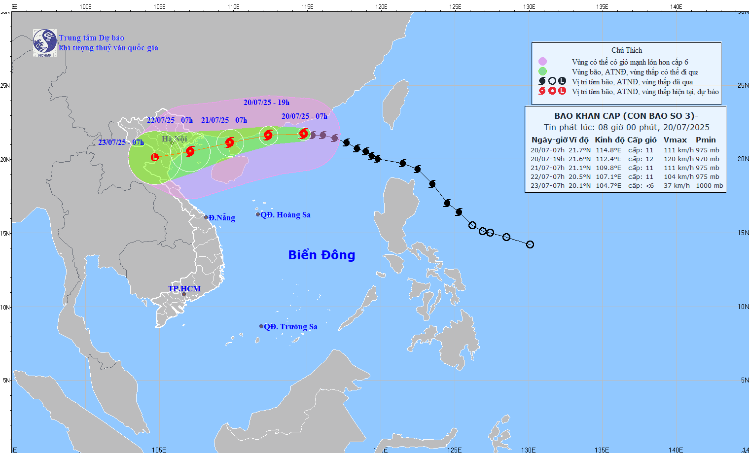
At 7:00 a.m. on July 22, Typhoon Wipha continued to move in the West Southwest direction at a speed of about 15km/h, the center of the storm was located on the coastal area from Quang Ninh to Ninh Binh, at about 20.5 degrees North latitude; 107.1 degrees East longitude.
Strong wind level 10-11, gust level 14. The danger zone is located north of latitude 19.5 degrees North latitude and west of longitude 112.5 degrees East longitude. Natural disaster risk level: level 3, affecting the northwestern sea area of the North East Sea and the Gulf of Tonkin.
At 7:00 a.m. on July 23, storm No. 3 Wipha continued to move in the West Southwest direction at a speed of about 10km/h, gradually weakening into a low pressure area. At this time, the center of the low pressure area was at about 20.1 degrees North latitude; 104.7 degrees East longitude, on the mainland of Upper Laos.
Wind power below level 6. The danger zone is located north of latitude 19.0 degrees North latitude and west of longitude 109.5 degrees East longitude. Natural disaster risk level: level 3, affecting the Gulf of Tonkin and mainland provinces from Quang Ninh to Thanh Hoa.
The northern sea area of the North East Sea will have strong winds of level 8-10, near the storm center level 11-12, gusting to level 15. Waves are 5.0-4.0m high; rough seas.
From the night of July 20, the sea area of the Gulf of Tonkin (including the islands of Bach Long Vi, Co To, Cat Hai) will gradually increase to level 6-7, then increase to level 8-9, near the storm center level 10-11, gust level4; waves from 2.0-4.0m high, near the storm center can reach 3.0-5.0m.
The sea is rough. From July 21, the southern Gulf of Tonkin will have winds gradually increasing to level 6-7, near the storm center level 8-9, gusts of level 11, waves 2.0-4.0m high; very rough seas.
Ships operating in the above sea areas are at risk of being affected by thunderstorms, tornadoes, strong winds and large waves.
The coastal area of Hai Phong - Quang Ninh may experience storm surges of 0.5-1.0m high. The water level in Hon Dau (Hai Phong) can reach 3.8-4.1m, at Cua Ong (Quang Ninh) can reach 4.8-5.2m. There is a high risk of flooding in low-lying coastal areas and river mouths at noon and afternoon of July 22.
The coastal area of Hai Phong - Quang Ninh may experience storm surges of 0.5-1.0m high. The water level in Hon Dau (Hai Phong) can reach 3.8-4.1m, at Cua Ong (Quang Ninh) can reach 4.8-5.2m. There is a high risk of flooding in low-lying coastal areas and river mouths at noon and afternoon of July 22.
From July 21 to July 23, the Northern and North Central regions are likely to experience a widespread period of heavy rain. Rainfall is generally from 100-200mm, in some places over 300mm.
In particular, the Northeast region, the Northern Delta, Thanh Hoa and Nghe An will have heavy to very heavy rain, with total rainfall ranging from 200-350mm, locally exceeding 600mm.

Warning of the risk of high-intensity rain, with rainfall exceeding 150mm in just 3 hours, people and tourists in the above areas should be on guard against flash floods, landslides in mountainous areas, midlands and urban flooding in low-lying areas.
Tourists need to closely monitor weather reports and strictly follow the recommendations of authorities. Limit travel to coastal localities and northern mountainous areas, especially Quang Ninh, Hai Phong, Lang Son, Lao Cai, Yen Bai, Thanh Hoa, Nghe An from July 21 to 23.
Avoid swimming in the sea, climbing mountains, going to the forest or visiting caves, waterfalls, and streams, which pose a high risk of flooding and landslides.
Sea, river and ferry to and from the island routes should be postponed or canceled until the weather is stable. Trains to Co To, Cat Ba... may be suspended.
In Hanoi and major cities in the North, it will still be sunny during the day, but in the evening and tonight, July 21, there is a possibility of thunderstorms and gusts of wind. Visitors should bring raincoats, limit going out in the evening and choose indoor activities such as visiting museums, exhibitions, historical sites, and cultural spaces.
Tourists who have schedules in affected provinces should proactively contact hotels, bus companies, and travel agents to update information on changes and support postponement/changement of schedules if necessary.