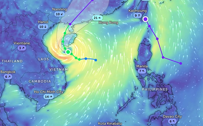
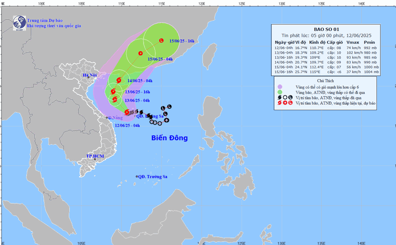
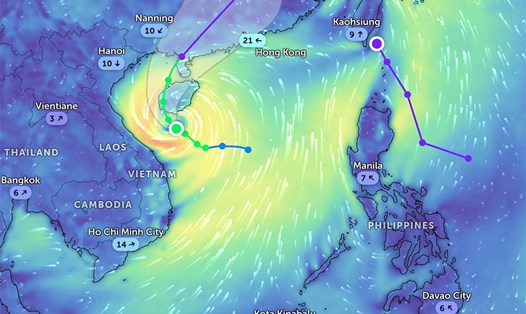
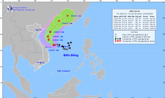
According to the latest storm news from the National Center for Hydro-Meteorological Forecasting, at 4:00 p.m. on June 12, storm No. 1 Wutip was about 150km south of Hainan Island. Intensity level 9, gust level 11.
It is forecasted that in the next 24 hours, the storm will move in a West-Northwest direction, at a speed of about 5-10km. As of 4:00 p.m. on June 13, the storm was over the western area of Hainan Island, China.
The danger zone extends from 15.5 - 20.5 degrees North latitude, 107.0 - 111.5 degrees East longitude.
Natural disaster risk level 3, for the western area of the North East Sea (including Hoang Sa archipelago), the offshore waters from Quang Tri to Quang Ngai, the waters of the Gulf of Tonkin. Warning of strong winds, big waves, rough seas.
Coastal areas from Hai Phong to Nghe An are likely to experience high water combined with high tides. The water level in Hon Dau can reach 3.9m, in Hon Ngu about 2.8m, causing the risk of flooding in low-lying coastal areas and river mouths from 5pm to 7pm on June 12 and 13.
On land, storm No. 1 will cause widespread heavy rain. From the evening of June 12 to the end of June 13, the area from Ha Tinh to Thua Thien Hue is forecast to have common rain of 100-180mm, some places over 350mm. South Nghe An and the provinces from Da Nang to Quang Ngai will have 40-90mm of rain, locally over 150mm.
From now until June 14, a flood will occur on rivers from Quang Binh to Quang Nam. The peak flood level on rivers fluctuates at level BD1-BD2; the Vu Gia River (Quang Nam) fluctuates at level BD2 and above level BD2 (due to the operation of hydropower plants in the upstream).
There is a high risk of flooding in low-lying areas along rivers, flash floods and landslides on steep slopes in mountainous areas of provinces from Quang Binh to Quang Nam.
The Northern Central Highlands and Binh Dinh regions will record rainfall of 15-30mm, with some places being higher, possibly over 50mm.
Meanwhile, the North will have scattered showers and thunderstorms. The Central Highlands and the South will have scattered showers and thunderstorms in the late afternoon and evening.
People and tourists need to be on guard during thunderstorms with the possibility of tornadoes, lightning and strong gusts of wind.
Weather forecast for the night of June 12 and tomorrow, September 13:
Hanoi
Lowest temperature: 25-27 degrees Celsius Highest temperature: 32-34 degrees Celsius Cloudy, scattered showers and thunderstorms.
North to northwest wind level 2-3.
Northwest
Lowest temperature: 23-26 degrees Celsius, some places below 22 degrees Celsius Highest temperature: 31-34 degrees Celsius, some places above 34 degrees Celsius Cloudy, scattered showers and thunderstorms at night; scattered showers and thunderstorms during the day.
Light wind.
Northeast
Lowest temperature: 24-27 degrees Celsius, mountainous areas below 22 degrees Celsius Highest temperature: 31-34 degrees Celsius Cloudy, scattered showers and thunderstorms at night, scattered showers and thunderstorms in the plains; scattered showers and thunderstorms during the day.
North to northwest wind level 2-3.
Thanh Hoa to Hue
Lowest temperature: 23-26 degrees Celsius Highest temperature: North 31-34 degrees Celsius; South 27-30 degrees Celsius Cloudy, South Nghe An and Ha Tinh areas have moderate rain, heavy rain and thunderstorms at night, showers and thunderstorms during the day in some places; South has heavy to very heavy rain and thunderstorms.
Northwest to west wind level 2-3, especially in the South level 3-4.
Da Nang to Binh Thuan
Lowest temperature: 24-27 degrees Celsius Highest temperature: North 28-31 degrees Celsius; South 30-33 degrees Celsius, some places above 33 degrees Celsius Cloudy, North has moderate rain, heavy rain, locally very heavy rain and thunderstorms at night, showers and thunderstorms in some places during the day; South has showers and thunderstorms in some places, Binh Dinh has moderate rain, heavy rain at night, locally very heavy rain and thunderstorms.
West to southwest wind level 3-4, coastal areas have gusts of level 7-8.
Central Highlands
Lowest temperature: 20-23 degrees Celsius Highest temperature: 26-29 degrees Celsius Cloudy, scattered showers and thunderstorms in some places, scattered showers and thunderstorms in the late afternoon and evening; in the North, there will be moderate rain at night, locally very heavy rain.
Southwest wind level 3.
Southern region
Lowest temperature: 24-27 degrees Celsius Highest temperature: 29-32 degrees Celsius Cloudy, scattered showers and thunderstorms in some places; scattered showers and thunderstorms in the late afternoon and evening.
Southwest wind level 3.