The tropical depression is forecast to develop into a super typhoon when it enters the Philippine Area of Responsibility (PAR) this weekend, according to the Tuesday warning of the Philippine Atmospheric, Geophysical and Astronomical Services Administration (PAGASA).
Initially, this was a low pressure area outside the PAR and had strengthened into a tropical depression.
The tropical depression is currently about 1,985 km northeast of Mindanao, with sustained winds of 55 km/h and gusts of 70 km/h.
The tropical depression is moving westward at a speed of about 20 km/h and is forecast to turn west-northwest, with a high probability of entering the PAR on Friday evening or on Saturday.

PAGASA said the tropical depression will continue to strengthen over the sea east of the Philippines throughout the forecast period.
The tropical depression is forecast to reach typhoon level on Thursday (November 6) and may become a super typhoon by the end of the week.
According to PAGASA's risk assessment, the likelihood of the storm making landfall in the Philippines is increasing, but the location and time of landfall are still uncertain as it is forecast to be more than five days away.
The tropical depression has not yet directly affected the Philippine mainland. However, from Saturday, the northern and eastern seas of the country may experience rough seas.
Tourists traveling by sea or planning to travel to coastal provinces should proactively monitor weather information and adjust their plans accordingly.
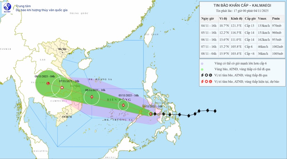
Meanwhile, Typhoon Kalmaegi has made landfall in the Philippines and is moving into the East Sea and officially becoming the 13th storm of the 2025 typhoon season.
According to the latest storm information from the National Center for Hydro-Meteorological Forecasting, from November 5, at 4:00 p.m. on November 4, the center of the storm was at about 10.7 degrees North latitude; 121.3 degrees East longitude, in the western sea area of the central Philippines, about 770km east of Song Tu Tay Island.
The strongest wind near the storm center is level 13 (134-149 km/h), gusting to level 16. Moving west at a speed of about 25km/h.
The impact of the storm is clearly affecting the weather in the North East Sea (including Hoang Sa special zone), Gulf of Tonkin, The sea area from South Quang Tri to Khanh Hoa and the East Sea area of the Central East Sea.
Typhoon Kalmaegi is forecast to officially enter the East Sea from November 5.
In addition, on the night of November 4 and November 5, in the southern Gulf of Tonkin, the sea area from South Quang Tri to Ca Mau, from Ca Mau to An Giang, the Gulf of Thailand, the northern East Sea area (including the special zone of Hoang Sa), the southern East Sea area (including the special zone of Truong Sa) will have scattered showers and thunderstorms; in the eastern sea area of the Central East Sea, there will be storms and rain.
During thunderstorms, there is a possibility of tornadoes, strong gusts of wind of level 6-7 and waves over 2.0m high.
All ships operating in the above sea areas need to proactively avoid strong winds, big waves and tornadoes in thunderstorms.


