According to the weather forecast from the National Center for Hydro-Meteorological Forecasting, due to the influence of storm No. 13 Kalmaegi, from the evening of November 6 to November 7, the area from Da Nang to Dak Lak will have very heavy rain with common rainfall of 150-300mm, some places exceeding 500mm.
Areas from South Quang Tri to Hue, Khanh Hoa and Lam Dong recorded rain of 100-250mm, locally over 400mm.
From November 7 to 8, rain will spread to the area from Bac Quang Tri to Thanh Hoa with an amount of 50-150mm, some places over 200mm. Warning of high-intensity heavy rain, which could reach over 200mm in 3 hours.
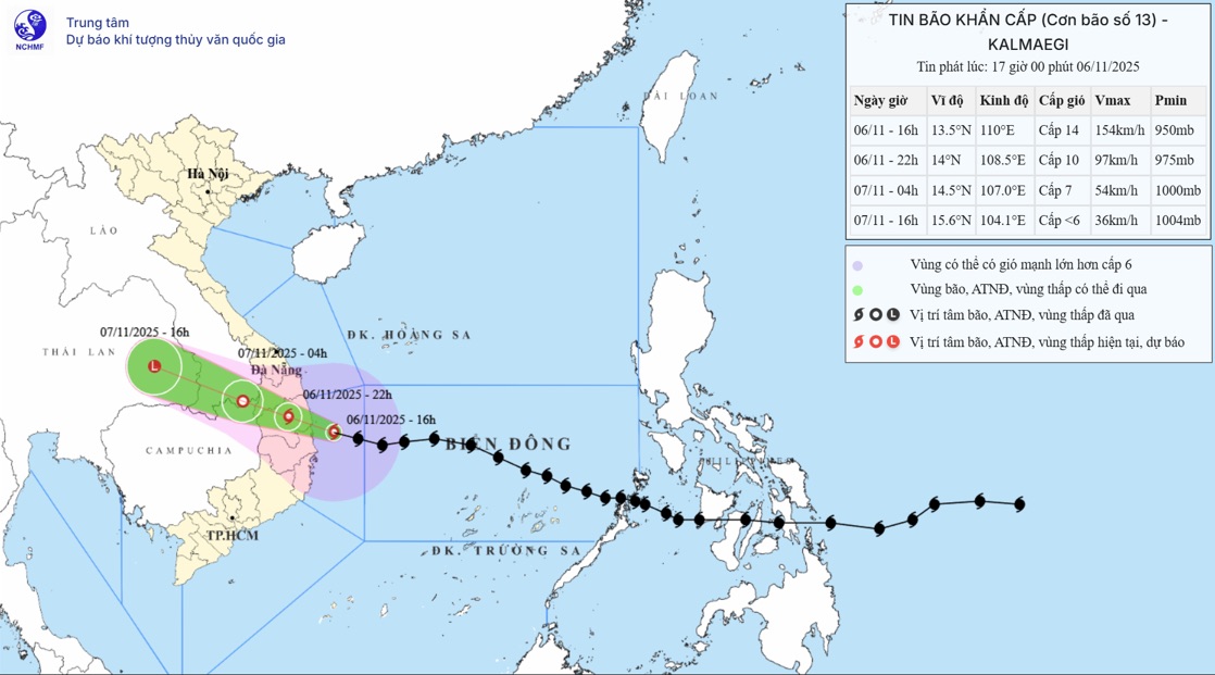
At 6:00 p.m. on November 6, the center of the storm was at about 13.7 degrees North latitude; 109.5 degrees East longitude, on the coastal area of Dak Lak - Gia Lai. The strongest wind is level 13 (134-149km/h), gusting to level 16.
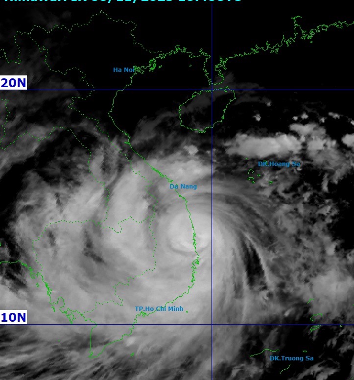
In the next 3 hours, the storm will move mainly in the West Northwest direction, at a speed of about 30km/h. The storm will officially make landfall tonight, November 6, earlier than yesterday's forecast due to its faster moving speed as it approaches the shore.
It is forecasted that by 10:00 p.m. on November 6, the storm will move west - northwest at a speed of about 30km/h and gradually weaken as it moves inland from Quang Ngai to Dak Lak, with the center at about 14.0°N; 108.5°E.
The storm intensity has decreased to level 10, gusting to level 12. The danger zone is determined within the range from latitude 11.50°N to 16.00°N and west of longitude 112.50°E.
The natural disaster risk level reached level 4 for the sea area from Quang Ngai to Dak Lak (including Ly Son) and the mainland east of the area from Quang Ngai to Gia Lai, North Dak Lak.
The areas at risk level 3 include the West of the Central East Sea, the sea area from South Quang Tri to Da Nang (including Cu Lao Cham) and Khanh Hoa, along with the mainland from South Quang Tri to Da Nang, South Dak Lak and North Khanh Hoa.
At 4:00 a.m. on November 7, the storm continued to move west-northwest at a speed of about 30km/h and weakened into a tropical depression when moving into the Southern Laos area, center at about 14.5°N; 107.0°E.
The strongest wind decreased to level 7, gusting to level 9. The danger zone will remain from latitude 11.50°N to 16.00°N and west of longitude 110.00°E, with a level 3 natural disaster risk for the sea area from South Quang Tri to Da Nang (including Ly Son and Cu Lao Cham), Khanh Hoa, and mainland from South Quang Tri to Da Nang, south of Dak Lak and north of Khanh Hoa.
At 4:00 p.m. on November 7, the weather system continued to weaken as it moved west-northwest at a speed of 25-30km/h and became a low pressure area when it reached the eastern part of Thailand, with the center at about 15.6°N; 104.1°E. The wind intensity decreased to below level 6.
From tonight, November 6 to November 9, there is a possibility of a flood on the rivers from Quang Tri to Lam Dong.
During this flood, the flood peak on the Bo River, Huong River (Hue City); Vu Gia-Thu Bon River (Da Nang City); Tra Khuc River, Ve River, Se San River (Quang Ngai); Kon River (Gia Lai); Ba River, Ky Lo River, Serpok River (Dak Lak) will increase to level BD2-BD3 and above level 3; Kien Giang River (Quang Tri); An Lao River, Lai Giang River (Gia Lai); Dinh Ninh Hoa River (Khanh Hoa), rivers in Lam Dong will rise above level 2; Gianh River, Thach Han River (Quang Tri), Cai Nha Trang River (Khanh Hoa) will rise above level 1.

The weather forecast for the North on the night of November 6 is that there will be rain in some places, from November 7 to November 8, there will be scattered showers and thunderstorms in some places, especially in the plains with rain, moderate rain and thunderstorms, locally heavy rain in some places. Cold at night and morning, some mountainous areas are cold.
The area from Thanh Hoa to North Quang Tri will have scattered showers and thunderstorms on the night of November6; from November 7 to November 8, there will be moderate rain, heavy rain, locally very heavy rain.
People and tourists should be on guard against the risk of flooding in low-lying areas along rivers, urban areas, and concentrated in provinces/cities from Quang Tri to Lam Dong. There is a high risk of flash floods on rivers and streams and landslides on steep slopes of provinces and cities from Quang Tri to Lam Dong.
Weather forecast for tonight, November 6, and tomorrow, November 7:
Hanoi
Lowest temperature: 20-22 degrees Celsius Highest temperature: 23-25 degrees Celsius Cloudy, sometimes with rain, showers and thunderstorms.
North to northwest wind level 2-3.Cold at night and morning.
Northwest
Lowest temperature: 18-21 degrees Celsius, some places below 17 degrees Celsius Highest temperature: 23-26 degrees Celsius, some places above 27 degrees Celsius Cloudy, some places have rain at night; scattered showers and thunderstorms during the day.
Light wind.Cold at night and morning, some places are cold.
Northeast
Lowest temperature: 19-22 degrees Celsius, mountainous areas below 18 degrees Celsius Highest temperature: 23-26 degrees Celsius Cloudy, some places have rain at night; scattered showers and thunderstorms during the day; in the plains, there is rain, moderate rain and thunderstorms, locally heavy rain.
North to northwest wind level 2-3.Cold at night and morning, some mountainous areas are cold.
Thanh Hoa to Hue
Lowest temperature: 19-22 degrees Celsius Highest temperature: North 22-25 degrees Celsius, South 25-28 degrees Celsius Cloudy, North has scattered rain and thunderstorms at night, moderate rain, heavy rain during the day, locally very heavy rain; South has heavy to very heavy rain.
North to northwest wind level 3; in the South, the wind will gradually increase to level 6-7, gusting to level 8-9.Cold at night and morning.During thunderstorms, there is a possibility of tornadoes, lightning and strong gusts of wind.
South Central Coast
Lowest temperature: 22-25 degrees Celsius Highest temperature: 26-29 degrees Celsius, some places above 29 degrees Celsius Cloudy, heavy to very heavy rain.
The wind gradually increased to level 6-7, then increased to level 8-9, near the storm center level 10-13, gusting to level 15-16.During thunderstorms, there is a possibility of tornadoes, lightning and strong gusts of wind.
Central Highlands
Lowest temperature: 18-21 degrees Celsius Highest temperature: 24-27 degrees Celsius Cloudy, with heavy to very heavy rain.
Northwest wind level 3-4, especially in the North from the evening the wind will gradually increase to level 6-7, near the storm center level 8-9, gusting to level 11.During thunderstorms, there is a possibility of tornadoes, lightning and strong gusts of wind.
Southern region
Lowest temperature: 23-26 degrees Celsius Highest temperature: 28-31 degrees Celsius, some places above 31 degrees Celsius Cloudy, scattered showers and thunderstorms in some places; in the afternoon and evening, there will be scattered showers and thunderstorms, locally heavy rain in some places.
Southwest wind level 3-4.During thunderstorms, there is a possibility of tornadoes, lightning and strong gusts of wind.
Ho Chi Minh City
Lowest temperature: 23-25 degrees Celsius Highest temperature: 28-30 degrees Celsius Cloudy, scattered showers and thunderstorms in some places; In the afternoon and evening, there will be scattered showers and thunderstorms, locally heavy rain in some places.
Southwest wind level 3-4.During thunderstorms, there is a possibility of tornadoes, lightning and strong gusts of wind.


