As storm No. 13 (storm Kalmaegi) approaches the mainland, VTV national TV channel simultaneously enters the "peak mode" of reporting natural disasters, with more continuous updates and visual images than ever.
From filming to the scene, the news bulletins of nhau, daily dong luc 24h, VTV Weather or VTC14... all increased the reporter team with a graphics system simulating the path, wind power and the level of impact of the storm.
In addition, there are live news every hour and every minute to update the developments of the storm.
In addition, the November 6 Lunch News bulletin also interviewed directly Mr. Mai Van Khiem - Director of the National Center for Hydro-Meteorological Forecasting, Department of Hydro-Meteorology.
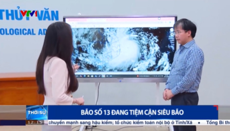
In recent years, the way of reporting storms on Vietnamese television has made great strides in technology. In addition to the traditional satellite map, the stations use a 3D - 4D model, helping the audience see the entire structure of storm clouds, strong winds, storm center and clearly rotated shape.
The effects of simulating rainfall, rising water, terrain... are presented in moving graphics (motion graphics), visual and easy to remember.
For these images to appear on TV, the production crew had to work almost 24/7. At major stations, meteorological data is continuously updated from the forecast of the National Meteorological Center, combined with foreign models.
On-site reporters use compact filming equipment, transmitting images via 4G/5G, helping the bulletin have real-life scenes in areas preparing for storm response.
In Vietnam, the CGI technology model is being learned and applied. Thanks to the application of XR, 3D graphics and satellite data updated in real time, today's storm news not only provides information but also has an intuitive warning, helping people understand, visualize easily, and prepare for more.
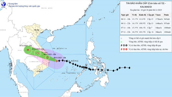
Last night and early this morning (November 6), storm No. 13 (storm Kalmaegi) moved west-southwest, at a very fast speed of about 30km/h and the time to get to shore is approaching.
According to the Department of Hydrometeorology, storm No. 13 Kalmaegi could destroy a level 4 house or an unstable house.
Around this evening, the center of the storm will enter the mainland areas of the provinces from Quang Ngai to Gia Lai. In particular, the eastern area of Gia Lai and Quang Ngai provinces is the area most directly and strongly affected by storm No. 13 on wind, with winds that can increase to level 10-12, gusting to level 14-15.


