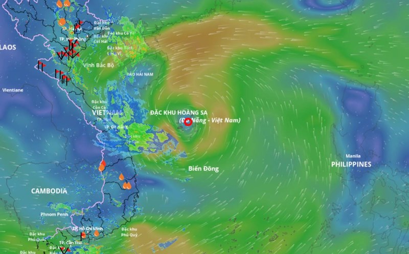
According to the National Center for Hydro-Meteorological Forecasting, at 4:00 p.m. on August 29, the center of the tropical depression was at about 16.6 degrees north latitude; 111.8 degrees east longitude, in the special waters of Hoang Sa, about 590km east-southeast of the northern Quang Tri area, about 450km east of Hue city.
The strongest wind near the center of the tropical depression is level 7 (50-61km/h), gusting to level 9. The tropical depression is moving northwest at a speed of 20-25km/h.
Tropical depression is about to strengthen into a strong storm of level 8
It is forecasted that in the next 12 hours, the tropical depression will strengthen into a storm. At 4:00 a.m. on August 30, the center of the storm was at about 17.3 degrees north latitude; 109.3 degrees east longitude, in the sea from Quang Tri to Da Nang, about 330km east-southeast of north Quang Tri. Strong wind level 8, gust level 10.
The danger zone is from 15 - 20 degrees north latitude; 107.5 - 113.5 degrees east longitude. Level 3 natural disaster risk in the northwest sea of the East Sea (including Hoang Sa special zone) and the sea area from Quang Tri to Da Nang.
It is forecasted that in the next 24 hours, the storm will move west-northwest at a speed of about 20km/h.
At 4:00 p.m. on August 30, the center of the storm was at about 17.7 degrees north latitude; 106.8 degrees east longitude, in the coastal area of Ha Tinh - Quang Tri. Strong wind level 8, gust level 10.
The danger zone is from 16 - 20 degrees north latitude; west of the longitude 111.5 degrees east longitude. Level 3 natural disaster risk in the northwest sea of the East Sea and the sea area from Thanh Hoa to Hue (including Hon Ngu island, Con Co special area).
It is forecasted that in the next 36 hours, the storm will continue to move westward at a speed of 20-25km/h, making landfall and gradually weakening into a low pressure area.
At 4:00 a.m. on August 31, the center was at about 17.8 degrees north latitude; 103.4 degrees east longitude, on the mainland of central Thailand. Wind speed decreases below level 6.
The danger zone is from 16 - 20 degrees north latitude; west of the 109 degrees east longitude. Level 3 natural disaster risk in the sea area from Thanh Hoa to Hue (including Hon Ngu island, Con Co special area).
Notable impacts of Tropical Depression/Storm
At sea, the northwest sea area of the East Sea (including Hoang Sa special zone) has strong winds of level 6-7, near the storm center level 8, gusts of level 10, waves 2-5m high, rough seas. From the night of August 29, the sea area from Thanh Hoa to Da Nang (including Hon Ngu island and Con Co special area) will have strong thunderstorms, winds gradually increasing to level 6-7, near the storm center level 8, gusts of level 10; waves 2-4m high, near the storm center 3-5m, rough seas.
Coastal areas of provinces from Nghe An to Hue have water levels rising 0.2-0.4m.
The weather at sea and in coastal mainland areas is very dangerous and unsafe for tourist boats, passenger ships, transport ships, cages and aquaculture areas.
On land, from the morning of August 30, the coastal area from Nghe An to Quang Tri will have winds gradually increasing to level 6, gusting to level 8. In particular, Ha Tinh - north of Quang Tri will have strong winds of level 6-7, near the storm center level 8, gusting to level 10. Note that from now on, strong thunderstorms with tornadoes may appear, especially before the tropical depression/storm directly affects.
Regarding heavy rain, from the night of August 29 to the end of August 31, the area from Thanh Hoa to Hue will have heavy to very heavy rain, with common rainfall of 200-350mm, some places over 600mm. From August 30 to the end of August 31, the midlands and deltas of the North and Da Nang city will have moderate rain, heavy rain, locally very heavy rain, common rainfall of 100-200mm, some places over 400mm.


