Updated from the National Center for Hydro-Meteorological Forecasting, at 4:00 a.m. on November 27, the center of storm No. 15 Koto was at about 13 degrees north latitude; 114.5 degrees east longitude, about 190 km north of Song Tu Tay Island. The strongest wind near the storm center is level 12 (118-133 km/h), gusting to level 15. The storm is moving west-northwest at a speed of about 15 km/h.
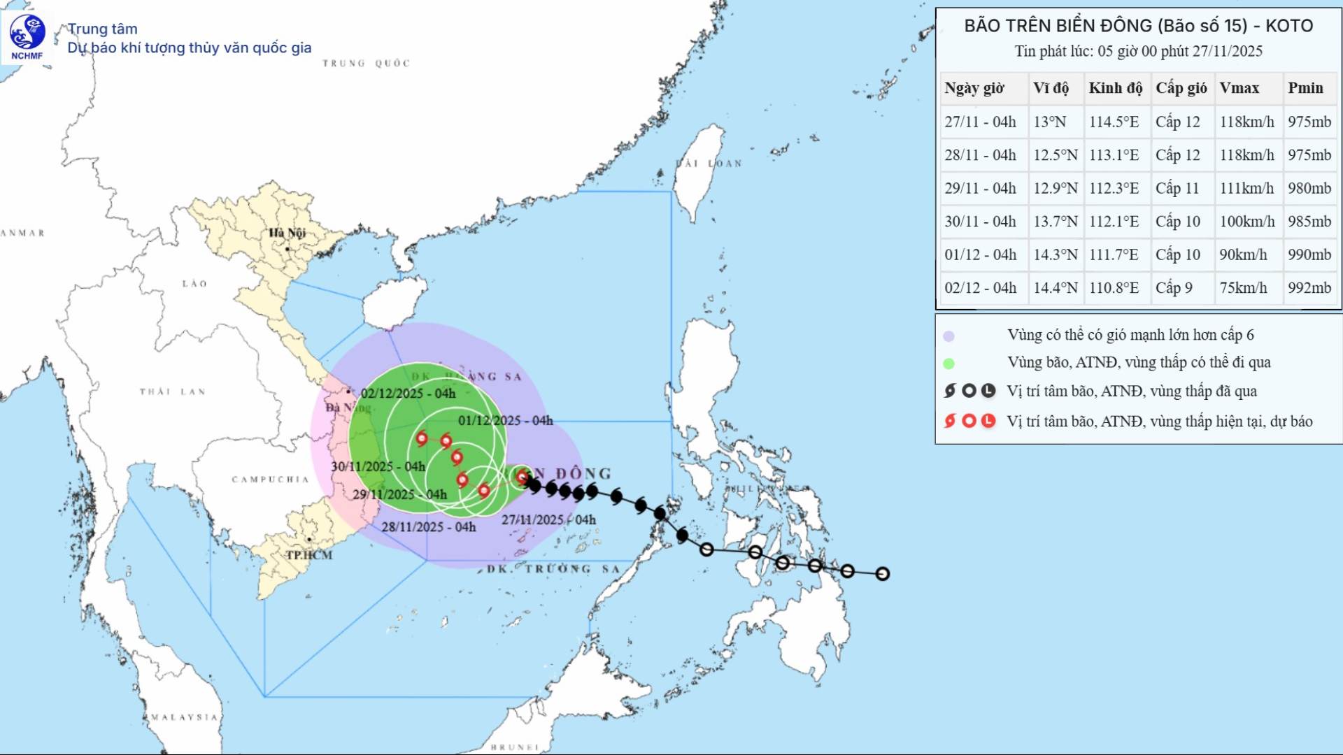
It is forecasted that in the next 24 hours, the storm will move west-southwest at a speed of 5-10 km/h. At 4:00 a.m. on November 28, the center of the storm was at about 12.5 degrees north latitude; 113.1 degrees east longitude, in the western sea area of the central East Sea, about 190 km northwest of Song Tu Tay Island. Storm intensity level 12, gust level 15.
It is forecasted that in the next 48 hours, the storm will move west-northwest, then northwest at a speed of about 5 km/h. At 4:00 a.m. on November 29, the center of the storm was at about 12.9 degrees north latitude; 112.3 degrees east longitude, in the western sea area of the central East Sea. Storm intensity level 11, gust level 14.
It is forecasted that in the next 72 hours, the storm will move north-northeast at a speed of 3-5 km/h. At 4:00 a.m. on November 30, the center of the storm was at about 13.7 degrees north latitude; 112.1 degrees east longitude, in the western sea area of the central East Sea. Storm intensity level 10, gust level 13.

The two storm impact scenarios were provided by Mr. Hoang Phuc Lam - Deputy Director of the National Center for Hydro-Meteorological Forecasting, Department of Hydro-Meteorology. The first scenario is that the storm is likely to move upward in a north-northwest direction, along the coast of the South Central provinces and with a probability of about 75 to 80%, which is quite high. With this option, the possibility of affecting the mainland with winds of level 6 or higher is relatively low. The wind may be around level 4-5.
"The area from Da Nang to Lam Dong is likely to experience a period of rain in the first days of December 2025, focusing on coastal areas. We believe that the rain is not too heavy, there may be moderate rain, that is, less than 50 mm within a day, but coastal areas will still have heavy rain, that is, from 50 - 100 mm within a day. That is the most likely impact according to the plan" - Mr. Lam said.
A worse scenario for the weather in the South Central Coast is that the storm does not move north, does not slide along the South Central Coast but goes straight to the shore. With this scenario, the storm will cause strong winds above level 6 inland. This is a current case with a probability of about 20 to 25%.
"With this plan, the storm will directly affect the mainland, causing winds above level 6 and rain. We predict that according to this plan, the rain will be 100 - 250 mm in the coastal area from Da Nang to Lam Dong from November 29 to December 1. We will closely monitor the next developments of the storm as well as the factors affecting the storm's trajectory and intensity to update in the next bulletins" - Mr. Lam commented.
At sea, the central East Sea area (including the northern sea area of Truong Sa) has strong winds of level 7-9; the area near the storm's eye has strong winds of level 10-12, gusting to level 15. Waves are 4-6 m high, near the center of the storm 7-9 m; the sea is rough.
Ship operating in the above-mentioned dangerous areas are likely to be affected by thunderstorms, whirlwinds, strong winds, and large waves.


