In some places in Quang Ninh and Hai Phong, the wind gusts to level 14.
Latest update from the National Center for Hydro-Meteorological Forecasting, due to the influence of storm No. 3's circulation, Bach Long Vi Island has strong winds of level 13, gusts of level 14; Co To Island has strong winds of level 13, gusts of level 16; Tien Yen (Quang Ninh) strong winds of level 9, gusts of level 11; Dam Ha (Quang Ninh) strong winds of level 10, gusts of level 13; Cua Ong (Quang Ninh) strong winds of level 12, gusts of level 14.
Phu Lien (Hai Phong) strong wind level 11, gust level 14; Cat Hai (Hai Phong) strong wind level 11, gust level 14; Dong Xuyen (Hai Phong) strong wind level 10, gust level 12; Ba Lat (Thai Binh) strong wind level 9, gust level 12; Van Ly (Nam Dinh) strong wind level 7, gust level 8.
Hai Duong has strong winds of level 12, gusts of level 13; Luc Ngan (Bac Giang) has strong winds of level 9, gusts of level 11; Hung Yen has strong winds of level 8, gusts of level 11; Bac Giang has strong winds of level 7, gusts of level 9; Bac Ninh has strong winds of level 7, gusts of level 10...
The Northeast region has had heavy to very heavy rain. The rainfall from 0:00 to 19:00 on September 7 was over 200mm in some places such as: Cat Ba (Hai Phong) 215mm, Dong Trieu (Quang Ninh) 224mm, Cam Pha (Quang Ninh) 213mm, Mau Son (Lang Son) 220mm, Phu Duc (Thai Binh) 409mm, Xuan Thuy (Nam Dinh) 221mm...
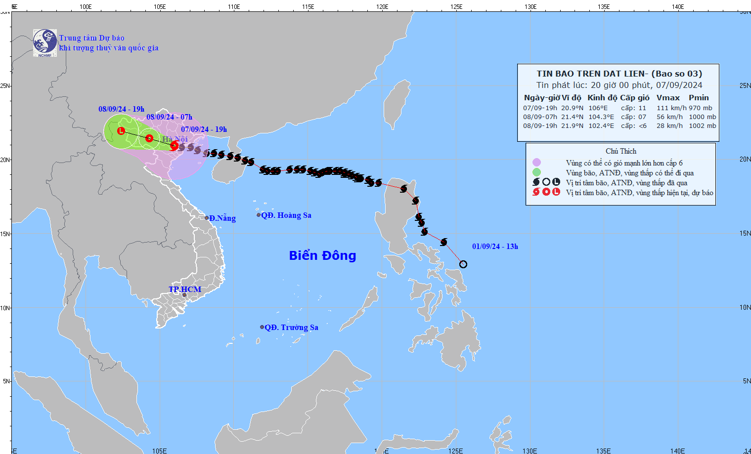
Storm No. 3 is still at level 10 - 11 when it moves inland.
At 7:00 p.m. on September 7 , the center of storm No. 3 was at approximately 20.9 degrees north latitude; 106.0 degrees east longitude, on land in the Northern Delta region. The strongest wind near the center of the storm was level 10-11 (89-117 km/h), gusting to level 14, moving west-northwest at a speed of 15-20 km/h.
It is forecasted that in the next 12 hours , storm No. 3 will move west-northwest at a speed of 15-20km/h, weakening into a tropical depression in the Northwest region. At 7:00 a.m. on September 8, the center of the tropical depression will be at about 21.4 degrees north latitude - 104.3 degrees east longitude; on the mainland in the Northwest region.
Strongest wind level 6-7, gust level 9-10.
In the next 24 hours , the tropical depression will move west-northwest at a speed of 15-20km/h, move inland, weaken and gradually dissipate.
Heavy rain in the Northeast tonight and tomorrow morning September 8
Regarding the impact of the storm at sea , the sea area of Bac Bo Gulf (including Bach Long Vi and Co To island districts) has strong winds of level 8-10, gusting to level 13; very rough seas.
In the Gulf of Tonkin (including Bach Long Vi and Co To island districts), waves are 3-5m high. In coastal waters from Quang Ninh to Ninh Binh, waves are 2-4m high.
Boat anchorage areas, aquaculture areas, dykes and seawalls in the above-mentioned dangerous areas are all likely to be affected by strong winds, large waves and storm surges/ebb.
On land , coastal areas from Quang Ninh to Thanh Hoa have strong winds of level 7-8, near the storm center level 9-11, gusting to level 14; deep inland areas in the Northeast have strong winds of level 6-8, gusting to level 9-11. The strong winds will continue tonight.
In the Northeast and Thanh Hoa from the evening of September 7 to the morning of September 8, there will be heavy to very heavy rain with common rainfall of 80-180mm, locally over 350mm.
In the afternoon and night of September 8, the two above areas will have moderate rain, some places will have heavy rain and thunderstorms with common rainfall of 20-50mm, some places will have over 100mm; especially in mountainous areas, there will be heavy rain, some places will have very heavy rain with common rainfall of 60-120mm, locally over 250mm.
In the Northwest, from the evening of September 7 to the morning of September 9, there will be heavy to very heavy rain with common rainfall of 100-350mm, locally over 500mm.
Heavy rains can cause flooding in low-lying areas; flash floods in small rivers and streams, and landslides on steep slopes.