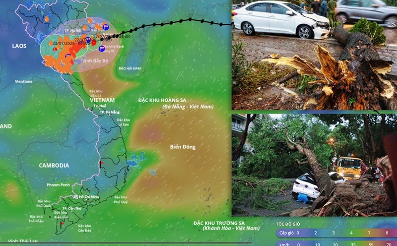
Storm No. 3 causes strong gusts of wind of level 8 in the center of Hanoi
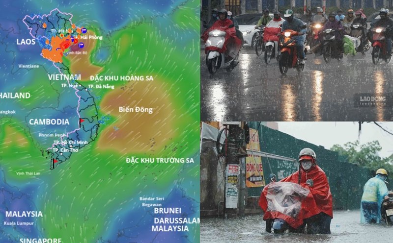
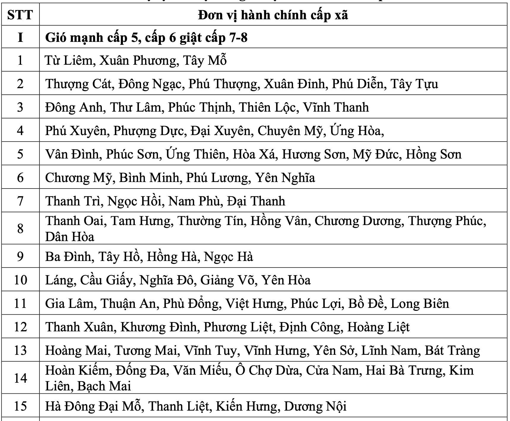
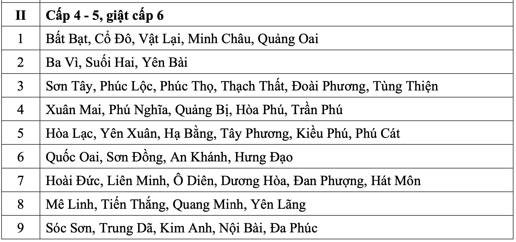
According to the Northern Hydrometeorological Station, today (July 22), the northern and western areas of Hanoi city will gradually increase to level 4 - 5, gusting to level 6.
The southern and central areas of the city will gradually have strong winds of level 5, sometimes level 6, gusting to level 7 - 8. Strong winds can break trees, damage houses, traffic works and infrastructure, endangering human life. The risk level of natural disasters due to storms for the southern area and the city center is level 3.

Mr. Nguyen Van Hiep - Deputy Director of the Northern Hydrometeorological Station warned that it is necessary to be on guard against strong winds occurring locally. In addition to the storm wind, Mr. Hiep also warned people to be vigilant against strong winds in thunderstorms and local strong winds affecting buildings.
"Hanoi is an area with many high-rise buildings, so this area may experience the effect of increased winds, causing these wind waves to increase abnormally" - Mr. Hiep warned.
The Deputy Director of the Northern Hydrometeorological Station also said that it is forecasted that from July 22 to July 23, Hanoi will have moderate rain, heavy rain to very heavy rain and thunderstorms.
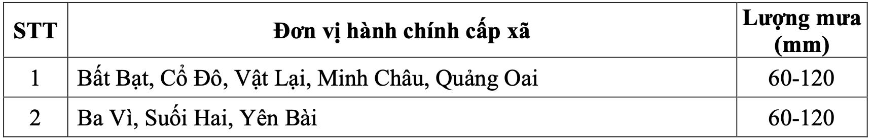
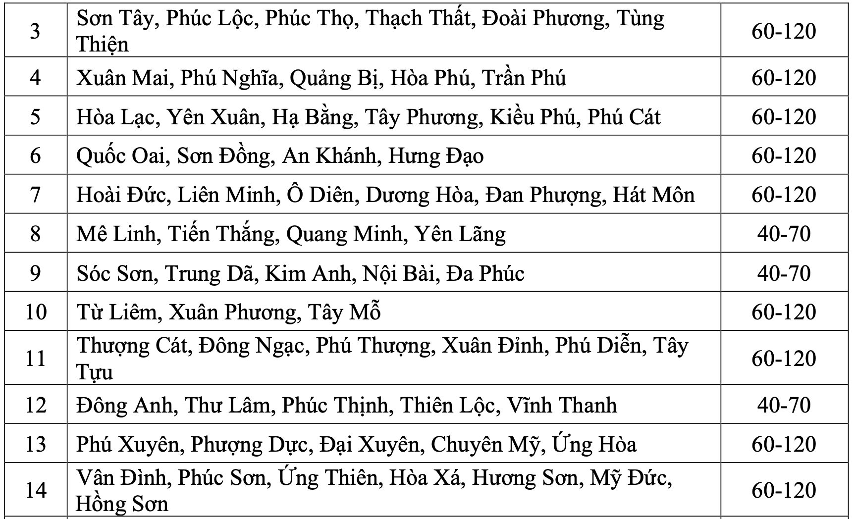
"In the northern part of the city, the common rainfall is 40 - 70mm, in some places over 100mm. The city center, the western and southern areas of the city will have common rainfall of 60 - 120mm, some places over 180mm" - Mr. Hiep said.
Regarding the impact of heavy rain, it can overload the urban drainage system, causing flooding in residential areas, traffic congestion due to flooding and reduced visibility when driving, causing slippery traffic and accidents.
The meteorological agency of the North also warned that the thunderstorms may be accompanied by tornadoes, lightning and strong gusts of wind that will break trees, damage houses, traffic works and infrastructure. High-intensity rain in a short period of time can cause landslides in mountainous areas, causing flooding in urban areas and low-lying areas. The warning level of natural disaster risk due to heavy rain is level 1.
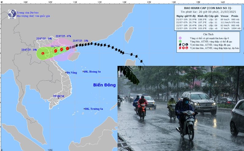
Developments of storm No. 3 and notable impacts today
At 7:00 a.m. on July 22, the center of the storm was at about 20.2 degrees north latitude; 106.7 degrees east longitude, in the coastal waters of Hai Phong - Ninh Binh. The strongest wind near the storm center is level 9 (75 - 88 km/h), gusting to level 12. The storm is moving west-southwest at a speed of about 15 km/h.
It is forecasted that in the next 12 hours, the storm will move west-southwest at a speed of about 10-15 km/h, gradually weakening into a tropical depression. At 7:00 p.m. on July 22, the center of the tropical depression was at about 19.9 degrees north latitude; 105.5 degrees east longitude, on the mainland from Hai Phong to Thanh Hoa. The strongest wind is level 6, gusting to level 8.
It is forecasted that in the next 24 hours, the tropical depression will continue to move west-southwest at a speed of about 10-15 km/h, gradually weakening into a low pressure area in the Upper Laos area. At 7:00 a.m. on July 23, the center of the low pressure area was at about 19.6 degrees north latitude; 103.8 degrees east longitude, winds below level 6.
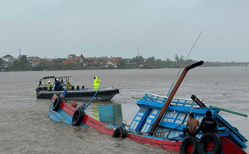
At sea, the northern sea area of the Gulf of Tonkin, including the special areas of Bach Long Vi, Co To, Van Don, Cat Hai, and Hon Dau island, will have strong winds of level 6-7, near the storm's eye level 8-9, gusting to level 12. Waves are 2-4 m high, 3-5 m near the storm's eye; very rough seas. The southern Gulf of Tonkin, including Hon Ngu Island, has strong winds of level 6-7, near the storm center level 8, gusting to level 11. Waves 2-4 m high, rough seas.
Coastal areas from Hung Yen to Quang Ninh have storm surge water from 0.5-1 m. The water level in Ba Lat (Hung Yen) is 2.4-2 1.6 m high, in Hon Dau (Hai Phong) is 3.9-4.1 m high, in Cua Ong (Quang Ninh) is 4.6-5 m high, in Tra Co (Quang Ninh) is 3.6-4 m high. There is a high risk of flooding in coastal areas and river mouths at noon and afternoon of July 22.
On land, coastal areas from Quang Ninh to Nghe An will have strong winds of level 6-7, near the storm center level 8-9, gusting to level 12. Deep inland areas of Hai Phong, Hung Yen, Bac Ninh, Hanoi, Ninh Binh and Thanh Hoa provinces and cities have strong winds of level 6, gusting to level 7-8. Level 9 winds can break tree branches, blow off roofs, and cause damage to houses.
Regarding heavy rain, from July 22 to July 23, in the Northern Delta, Thanh Hoa and Nghe An, there will be heavy to very heavy rain and thunderstorms with common rainfall of 100-200 mm, locally over 300 mm. Other places in the Northern region and Ha Tinh will have moderate rain, heavy rain, locally very heavy rain and thunderstorms with common rainfall of 50-100 mm, locally over 150 mm.
Warning of the risk of heavy rain over 150 mm in 3 hours. Heavy rainfall in a short period of time can cause flash floods, landslides in mountainous areas, and flooding in low-lying areas.