This morning, August 25, Hanoi experienced showers and thunderstorms, the temperature dropped significantly compared to yesterday. Meanwhile, storm No. 5 is about to make landfall, the storm's circulation is very large. Although Hanoi is not in the focus area affected by the storm, it will still be affected.

Discussing the detailed impact of storm No. 5 on Hanoi, Mr. Nguyen Van Hiep - Deputy Director of the Northern Hydrometeorological Station said that from the morning of August 25 to 26, Hanoi city will have moderate rain, heavy rain, some places with very heavy rain and thunderstorms. During thunderstorms, it is necessary to be on guard against the risk of tornadoes, lightning and strong gusts of wind.
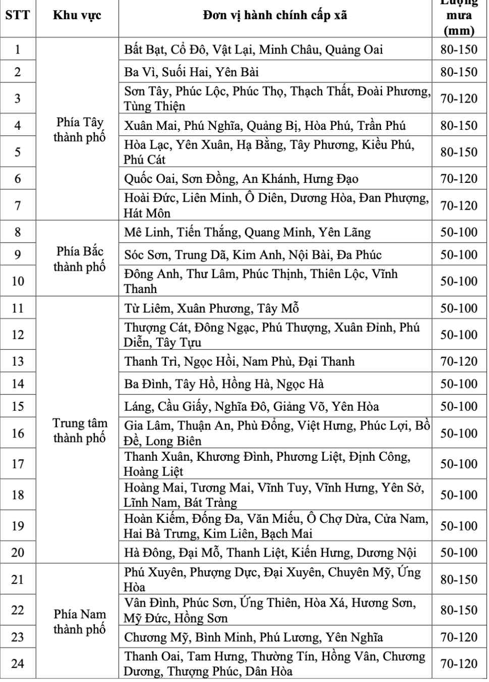
"The total rainfall on August 25 and 26 in the northern and central city is generally 50 - 100mm, in some places over 150mm. The western and southern areas of the city are generally 70 - 150mm, some places over 200mm" - Mr. Hiep provided detailed information on rainfall forecast.
The meteorological agency of the Northern Region warned that the thunderstorms could be accompanied by tornadoes, lightning and strong gusts of wind that could break trees, damage houses, traffic works and infrastructure.
Heavy rain overloaded the urban drainage system, causing flooding in residential areas, urban areas and low-lying areas, traffic congestion due to flooding and reduced visibility when driving, causing slippery traffic and accidents. High-intensity rain in a short period of time can cause landslides in mountainous areas, where the terrain is steep.
Regarding the strong wind situation, from the morning of August 25, Hanoi is forecast to have winds gradually increasing to level 4, sometimes level 5, gusting to level 6.

Regarding key areas affected by strong winds, according to Mr. Mai Van Khiem - Director of the National Center for Hydro-Meteorological Forecasting, from the morning of August 25, on land from Thanh Hoa to North Quang Tri, the wind will gradually increase to level 8-11, gusting to level 12-14.
"In the southern Thanh Hoa - Ha Tinh area, there will be strong winds of level 12-14, gusting to level 15-16" - Mr. Khiem especially noted.
Coastal areas from Quang Ninh to Ninh Binh provinces will have winds gradually increasing to level 6-8, gusting to level 9-10.
According to Mr. Khiem, it is forecasted that from the morning of August 25 to the end of August 26, in the midlands and deltas of the North, Lao Cai and from Thanh Hoa to Thua Thien Hue, there will be widespread heavy rain with common rainfall of 100-150mm, locally over 250mm.
"In the area from Thanh Hoa to North Quang Tri, there will be heavy to very heavy rain with common rainfall of 200-400mm, locally over 700mm. Warning of the risk of heavy rain over 200mm in 3 hours" - Mr. Khiem emphasized.
In addition, from August 25 to 26, the Hanoi capital will have moderate rain, heavy rain and thunderstorms. On August 25, Da Nang city had rain, moderate rain and thunderstorms. From August 25 to 26, Ho Chi Minh City will have rain, showers and thunderstorms, concentrated in the afternoon and evening. During thunderstorms, it is necessary to be on guard against the risk of tornadoes and strong gusts of wind.
From the afternoon of August 25 to 27, the Upper and Central Laos regions will have heavy rain with common rainfall of 100-250mm, with some places in the Central Laos region having over 500mm.


