Updated from the National Center for Hydro-Meteorological Forecasting, at 7:00 a.m. on September 7, the center of storm No. 7 Tapah was at about 18.7 degrees north latitude - 114.6 degrees east longitude, in the northern sea area of the northern East Sea. The strongest wind near the storm center is level 9 (75-88km/h), gusting to level 11.

According to Mr. Mai Van Khiem - Director of the National Center for Hydro-Meteorological Forecasting, Department of Hydro-Meteorology, in the past 3 hours, storm No. 7 has barely moved.
"It is forecasted that in the next 24 hours, the storm will move northwest, at a speed of 10-15km/h and continue to strengthen. The strongest intensity is when approaching the mainland coast of Guangdong province (China)" - Mr. Khiem said.
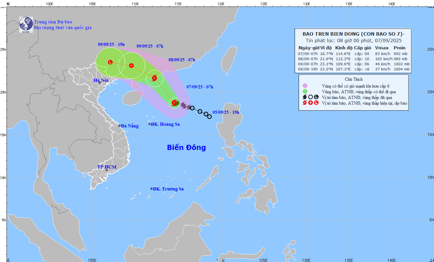
According to Mr. Khiem, at 7:00 a.m. on September 8, the center of the storm was at about 21.6 degrees north latitude - 112.3 degrees east longitude, in the sea south of Guangdong province (China). Strong wind level 10, gust level 13.
The danger zone is within the northern latitude of 17.5 degrees north latitude and longitude of 111.5 - 117 degrees east longitude. Natural disaster risk level 3, affecting the northern sea area of the northern East Sea.
It is forecasted that in the next 48 hours, the storm will move northwest at a speed of about 15km/h and gradually weaken into a tropical depression.
At 7:00 a.m. on September 9, the center of the tropical depression was at about 23.1 degrees north latitude - 109.6 degrees east longitude, in the mainland area of Guangdong province (China). Strong wind level 6, gust level 8.
The danger zone is within the northern latitude of 18.0 degrees north latitude and longitude of 110 - 115 degrees east longitude. Natural disaster risk level 3, affecting the northwestern sea area of the northern East Sea.
It is forecasted that in the next 60 hours, the storm will continue to move west-northwest, at a speed of 15-20km/h and weaken into a low pressure area.
At 7:00 p.m. on September 9, the center of the low pressure area was at about 23.5 degrees north latitude - 107.1 degrees east longitude, in the mainland area of Guangxi province (China). Wind intensity below level 6.
According to the Director of the meteorological agency, regarding the impact of the storm at sea, the sea area north of the northern East Sea will have strong winds of level 7-8, the area near the storm center will have strong winds of level 9 - 10, gusts of level3; waves 3 - 5m high, very rough seas. Ship operating in the above-mentioned dangerous areas are likely to be affected by thunderstorms, whirlwinds, strong winds and large waves.
Regarding the unique characteristics of this storm, according to Mr. Khiem, this is a storm formed on the tropical convergence zone. The location of the storm's formation is in the northern area of the East Sea, however, the point of storm formation is quite high, in the northern area of the North East Sea and the direction of movement is much higher than the north. The time when typhoons typically hit the North and have begun to shift south and affect the Central region, but this typhoon makes landfall in China.
"Although it will make landfall in China, after making landfall, storm No. 7 will quickly weaken into a low pressure area, then drift westward, towards our country. It is likely that from the afternoon and night of September 9 to 11, the post-storm No. 7 circulation will cause a large-scale heavy rain in the North, focusing on the midlands and mountainous areas of the Northeast" - Mr. Khiem commented.