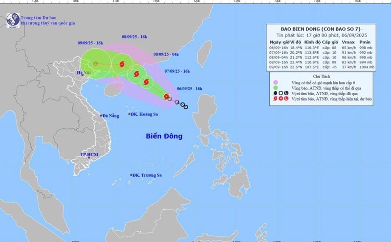
Latest update from the National Center for Hydro-Meteorological Forecasting, this afternoon, September 6, the tropical depression in the eastern sea of the North East Sea has strengthened into a storm, storm No. 7.
At 4:00 p.m., the center of the storm was at about 18.4 degrees north latitude; 116.3 degrees east longitude, in the sea east of the North East Sea. The strongest wind near the storm center is level 8 (62 - 74km/h), gusting to level 10. Moving northwest, speed 15km/h.
It is forecasted that in the next 24 hours, the storm will move northwest, at a speed of 10 - 15km/h and continue to strengthen.
At 4:00 p.m. on September 7, the center of the storm was at about 20.2 degrees north latitude - 113.8 degrees east longitude, about 420km northeast of Hoang Sa Special Zone. The strongest wind is level 9 - 10, gusting to level 12.
It is forecasted that in the next 36 hours, the storm will continue to move northwest at a speed of 10 - 15 km/h and will strengthen.
At 4:00 a.m. on September 8, the center of the storm was at about 21.2 degrees north latitude - 112.6 degrees east longitude, about 110km south-southeast of Hong Kong (China). The strongest sticking force is level 10, gusting to level 13.
It is forecasted that in the next 48 hours, the storm will move northwest, at a speed of 15km/h and gradually weaken.
At 4:00 p.m. on September 8, the center of the storm was at about 22.4 degrees north latitude - 110.8 degrees east longitude, in the mainland of Guangdong province (China). The strongest wind is level 9, gusting to level 12.
It is forecasted that in the next 48 to 72 hours, the storm will move westward, traveling about 15km per hour and weakening into a tropical depression, then a low pressure area.
At 4:00 p.m. on September 9, the center of the low pressure area was at about 22.5 degrees north latitude - 107.5 degrees east longitude, in the mainland area of Guangxi province (China). Intensity below level 6.
Regarding the impact of the tropical depression/storm, at sea, the northeastern sea of the East Sea will have strong winds of level 6 - 7, then increase to level 7 - 8; the area near the storm center will have strong winds of level 9 - 10, gusting to level 13.Waves are 3 - 5 m high, the sea is very rough.
Ships operating in the danger zone are likely to be affected by thunderstorms, whirlwinds, strong winds and large waves.