According to the latest storm information from the Vietnam National Center for Hydro-Meteorological Forecasting at 5:00 p.m. on September 6, the tropical depression in the eastern sea of the northern East Sea has strengthened into a storm, storm No. 7.
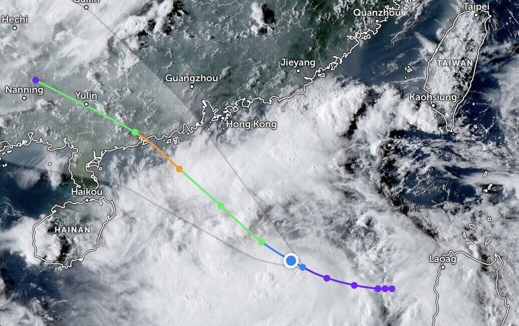
At 4:00 p.m., the center of the storm was at about 18.4 degrees North latitude, 116.3 degrees East longitude, in the eastern sea of the northern East Sea. The strongest wind near the storm center is level 8 (62-74km/h), gusting to level 10. Moving northwest, speed 15km/h.
Meanwhile, the storm and tropical depression bulletin of the Philippine Atmospheric, Geophysical and Astronomical Services Administration (PAGASA) on the afternoon of September 6 said that the tropical depression in the East Sea named Lannie in the Philippines is strengthening and has left the Philippine Forecast Area (PAR).
According to PAGASA's typhoon forecasters, Typhoon No. 7 forming from this tropical depression will move mainly northwest towards southern China. The system is forecast to strengthen into a tropical storm on the night of September 6 or early morning of September 7 as it moves over the East Sea.
The US Navy's Joint Typhoon Warning Center (JTWC) said that tropical depression 22W (called Lannie in the Philippines) is located 515 km south-southeast of Hong Kong (China) and has been moving west-northwest at a speed of 13 km/h for the past 6 hours.
Weather conditions are forecast to be favorable for the system to strengthen into storm No. 7 Tapah in the East Sea. After forming, Tapah will move northwest and make landfall on the southern coast of China in the coming days. It is forecasted that after making landfall, this system will soon weaken and dissipate rapidly.
The China Meteorological Administration (CWA) said that although Tapah, the latest storm in the East Sea, is far from the island and is forecast to make landfall in southern China on the morning of September 8, Taipei city authorities have warned of a high possibility of heavy rain on the afternoon of September 7. Due to the impact of Typhoon Tapah, strong winds are forecast to occur in coastal areas of Tan Bac, Nghi Lan and Binh Dong until the morning of September 7.
Faced with the possibility of being affected by Typhoon No. 7 Tapah, the Hong Kong Weather Forecast Agency (China) will assess the need to issue a warning signal for Typhoon No. 3 on September 7 when Typhoon No. 7 will be about 200km from Hong Kong (China) early next week. Storm No. 7 in the East Sea is expected to enter the west coast of Guangdong on the morning of September 8.
Previously, the Hong Kong Meteorological Agency (China) issued warning No. 1 at 22:20 on the evening of September 5 due to the influence of the tropical depression circulation in the East Sea. In Hong Kong (China), the wind is forecast to gradually increase and the weather is unstable on September 7. Showers and thunderstorms are expected on September 8. Due to the impact of the storm, there is a possibility of rough seas on the morning of September 8, accompanied by large waves.