According to the National Center for Hydro-Meteorological Forecasting, at 7:00 a.m. on July 18, the center of storm Wipha was at about 17.0 degrees north latitude; 124.5 degrees east longitude, in the sea east of Luzon Island (Philippines). The strongest wind near the storm center is level 8 (62-74km/h), gusting to level 10. The storm is moving northwest at a speed of about 20km/h.
According to Mr. Mai Van Khiem - Director of the National Center for Hydro-Meteorological Forecasting, in the next 24 hours, the storm is forecast to move mainly northwest, traveling 20 - 25km per hour, likely to enter the East Sea and continue to strengthen.

At 7:00 a.m. on July 19, the center of the storm was at about 19.5 degrees north latitude; 119.9 degrees east longitude, in the northeastern sea area of the northern East Sea. The strongest wind near the storm center is level 8-9, gusting to level 11.
The dangerous area in the next 24 hours will be determined from latitude 17.5 to 22 degrees north; east of longitude 118.5 degrees east. Level 3 natural disaster risk, the affected area is the northeastern sea area of the northern East Sea.
"In the next 48 hours, the storm will move west-northwest at a speed of about 20km/h and is likely to strengthen" - Mr. Khiem added.
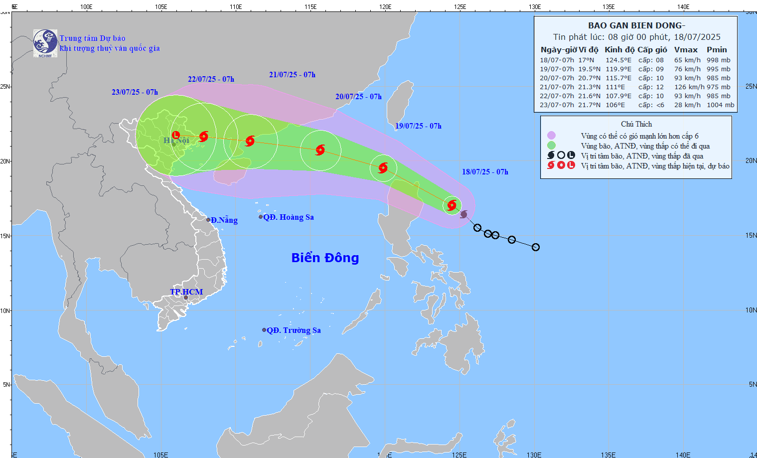
At 7:00 a.m. on July 20, the center of the storm was at about 20.7 degrees north latitude; 115.7 degrees east longitude, about 590km east of Zhejiang Peninsula (China). The strongest wind near the storm center is level 10, gusting to level 12.
The danger zone is determined to be north of latitude 18.5 degrees north; east of longitude 114 degrees east. Level 3 natural disaster risk, the affected area is the northern sea area of the northern East Sea.
In the next 72 hours, the storm will continue to move west-northwest at a speed of about 20km/h and continue to strengthen.
At 7:00 a.m. on July 21, the center of the storm was at about 21.3 degrees north latitude; 111.0 degrees east longitude, in the sea east of Zhou Peninsula (China). The strongest wind near the storm center is level 11-12, gusting to level 15.
The danger zone is determined to be north of latitude 18.5 degrees north; from 109 to 117 degrees east. Level 3 natural disaster risk, the affected area is the northern sea area of the northern East Sea.
"First of all, it is necessary to note the impact on the sea, from the afternoon of July 18, the sea area east of the northern East Sea will have winds gradually increasing to level 6 - 7, the area near the storm's eye will have strong winds of level 8-9, gusts of level 11; waves 3-5m high, very rough seas. Ship operating in the above dangerous waters are likely to be affected by thunderstorms, whirlwinds, strong winds and large waves" - Mr. Khiem warned.