Storm news near East Sea
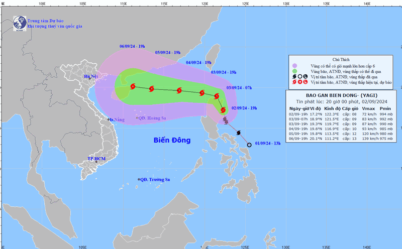
At 1:00 a.m. on September 3, the center of storm Yagi was at approximately 18.0 degrees North latitude; 121.5 degrees East longitude, in the northern area of Luzon Island (Philippines). The strongest wind was level 8, gusting to level 11, moving in the North-Northwest direction, at approximately 20 km/h.
Forecast until 1am tomorrow (September 4), location 19.3 degrees North latitude, 118.8 degrees East longitude; about 880km east of Hainan Island (China); moving West Northwest, about 20km/h, moving into the East Sea, wind force level 9, gust level 12. Dangerous area north of latitude 16.5N; east of longitude 118.0; RRTT level 3: Northeast of the North East Sea area.
At 1:00 a.m. on September 5, the location was at 19.2 degrees North latitude, 116.3 degrees East longitude, about 590 km east of Hainan Island (China); moving west, about 10 km/h; wind force level 11, gust level 14. Dangerous area north of latitude 17.5N; east of longitude 114.0E; RRTT level 3: east of the North East Sea area.
At 1:00 a.m. on September 6, the location was 19.1 degrees North latitude, 113.2 degrees East longitude, about 240km east of Hainan Island (China); moving west, about 10km/h; wind force level 13, gust level 16. Dangerous area north of latitude 17.0N; east of longitude 111.0E; RRTT level 3: north of the North East Sea area.
Warning from the next 72 to 120 hours, the storm will move mainly to the West, 10km per hour, with the possibility of increasing in intensity.
Heavy rain warning in the Central Highlands and Southern regions
The National Steering Committee for Natural Disaster Prevention and Control said that in the afternoon and evening of September 3, the Central Highlands and the South will have moderate rain, heavy rain and thunderstorms, locally very heavy rain with common rainfall from 20-40mm, locally over 100mm.
During the day and night of September 3, the Central region will have scattered showers and thunderstorms, locally heavy rain with rainfall from 15-30mm, locally over 70mm (thunderstorms concentrated in the evening and at night). Thunderstorms are likely to cause tornadoes, lightning and strong gusts of wind.
Heavy rain and localized heavy rain can cause flooding in low-lying areas; flash floods in small rivers and streams, and landslides on steep slopes.
From noon and afternoon of September 3, the northeastern sea area of the North East Sea will have winds gradually increasing to level 6, near the storm center to level 8, gusting over level 11; rough seas, waves 2.0-5.0m high.
During the day and night of September 3, the sea area south of the Central East Sea will have strong southwest winds of level 6, gusting to level 7-8, rough seas, waves 2.0-3.0m high; the sea area from Ninh Thuan to Ca Mau, the sea area west of the South East Sea area (including the sea area west of Truong Sa archipelago) will have strong southwest winds of level 5, sometimes level 6, gusting to level 7-8, rough seas, waves 2.0-3.0m high.
In addition, the North, Central and South East Sea (including the waters of the Hoang Sa and Truong Sa archipelagos), the waters from Quang Tri to Ca Mau, Ca Mau to Kien Giang and the Gulf of Thailand will have showers and thunderstorms. During thunderstorms, there is a possibility of tornadoes and strong gusts of wind of level 7-8, beware of wave heights sometimes increasing above 2.0m.
Regarding the hydrological situation, water levels of rivers in the Northern region: The water levels of the downstream Red River and Thai Binh River at Pha Lai station change slowly, are affected by tides and are affected by the regulation of hydroelectric reservoirs on the upper line; the water level at 7:00 a.m. on September 3 on the Red River at Hanoi station was 2.98m; the Thai Binh River at Pha Lai station was 1.37m.
Water levels of rivers in the Central and Central Highlands regions: Water levels of rivers change slowly, fluctuating according to reservoir and tidal regulation.
Water levels of rivers in the South: Water levels in the upper reaches of the Mekong River continue to rise with the tide. On September 6, the highest water level of the day was at 2.42m in Tan Chau and 2.40m in Chau Doc.