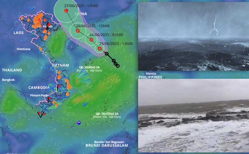
Updated from the National Center for Hydro-Meteorological Forecasting, at 1:00 p.m. on June 26, the center of the tropical depression was at about 20.7 degrees north latitude; 110.3 degrees east longitude, on the eastern coast of Zhou Peninsula (China).
The strongest wind near the center of the tropical depression is level 6 (39 - 49km/h), gusting to level 8. The tropical depression is moving northwest at a speed of about 15km/h.
It is forecasted that in the next 24 hours, the tropical depression will continue to move northwest at a speed of 10 - 15km/h and gradually weaken into a low pressure area. At 1:00 p.m. on June 27, the center of the low pressure area is forecast to be at about 23 degrees north latitude; 108.5 degrees east longitude, in the area of Guangxi province (China). The strongest wind near the center of the low pressure area is below level 6.
The dangerous area at sea with strong winds of level 6 or higher is located north of latitude 19.5 and between 109 and 112 degrees east longitude. The natural disaster risk level is level 3 for the northwestern sea area of the northern East Sea.
Regarding the impact of the tropical depression, in the afternoon and evening of June 26, the northwestern sea area of the northern East Sea will continue to have thunderstorms, strong winds of level 6, gusts of level 8; rough seas, waves from 2 to 3m high. Ships operating in dangerous areas are at risk of being affected by thunderstorms, tornadoes, strong winds and large waves.