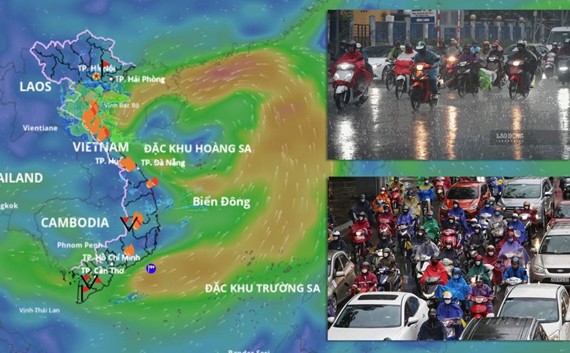
According to the National Center for Hydro-Meteorological Forecasting, at 1:00 p.m. on August 17, the center of the tropical depression was at about 17.4 degrees north latitude; 111.1 degrees east longitude, in the northwest sea of the Hoang Sa special zone.
The strongest wind near the center of the tropical depression is level 6 (39 - 49km/h), gusting to level 8; moving northwest at a speed of about 15km/h.
It is forecasted that in the next 24 hours, the tropical depression will move northwest at a speed of about 15 km/h. At 1:00 p.m. on August 18, the center of the tropical depression was at about 19.5 degrees north latitude; 108.3 degrees east longitude; in the North of the Gulf of Tonkin. The strongest wind near the center of the tropical depression is level 6, gusting to level 8.
Level 3 natural disaster risk, the affected area is the western sea area of the North East Sea (including the sea area of Hoang Sa special zone), the Gulf of Tonkin area (including the Bach Long Vi special zone).
It is forecasted that in the next 48 hours, the tropical depression will move north-northeast at a speed of about 10 - 15 km/h and gradually weaken into a low pressure area. At 1:00 p.m. on August 19, the center of the tropical depression was at about 22.2 degrees north latitude; 107 degrees east longitude; in the southern area of Guangxi province (China). The strongest wind near the center of the tropical depression is below level 6.
Level 3 natural disaster risk, the affected area is the Northern Gulf of Tonkin (including Bach Long Vi special zone and Co To special zone).
Regarding the impact of the tropical depression at sea, the sea area west of the North East Sea (including the sea area of Hoang Sa) will have thunderstorms and strong winds of level 6 - 7, gusts of level 8 - 9, waves 2 - 3.5m high, rough seas.
From the evening of August 17, the Gulf of Tonkin will have winds gradually increasing to level 6, gusts of level 8, waves 2-3m high, rough seas. Ship operating in the above-mentioned dangerous areas are likely to be affected by thunderstorms, whirlwinds, strong winds, and large waves.