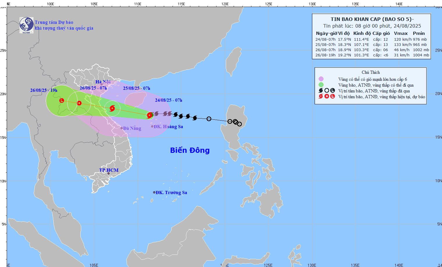
Latest update from the National Center for Hydro-Meteorological Forecasting, at 7:00 a.m. on August 24, the center of the storm was at about 17.5 degrees north latitude; 111.4 degrees east longitude, in the northwest sea of Hoang Sa special zone, about 620 km from Nghe An, about 600 km east of Ha Tinh. The strongest wind near the storm center is level 12 (118-133 km/h), gusting to level 15.
The closer to the shore, the stronger the storm tends to get
It is forecasted that in the next 24 hours, the storm will move west-northwest at a speed of about 20 km/h and is likely to strengthen.
At 7:00 a.m. on August 25, the center of the storm was at about 18.3 degrees north latitude; 107.1 degrees east longitude, in the southern Gulf of Tonkin, about 160 km east of Nghe An, about 140 km east of Ha Tinh. Strong wind level 12-13, gust level 15.
The danger zone is from 16 to 20 degrees north latitude; 106.5 to 114.5 degrees east longitude. Level 3 natural disaster risk for the western sea area of the northern East Sea (including Hoang Sa special zone), the Gulf of Tonkin, the southern sea area of Quang Tri - Hue City (including Hon Ngu island, Con Co special zone); level 4 for coastal waters from Thanh Hoa to Quang Tri.
According to the meteorological agency, it is forecasted that around noon to tomorrow afternoon, August 25, storm No. 5 will make landfall in Thanh Hoa to northern Quang Tri.
It is forecasted that in the next 48 hours, the storm will move west-northwest at a speed of 15-20 km/h and gradually weaken.
At 7:00 a.m. on August 26, the center of the tropical depression was at about 18.9 degrees north latitude; 103.3 degrees east longitude, in the upper Laos area. Strong wind level 6, gust level 8.
The danger zone is from 16.0 to 20 degrees north latitude; west of the longitude 108.5 degrees east longitude. Level 3 natural disaster risk for the Gulf of Tonkin, the southern sea area of Quang Tri - Hue City (including Hon Ngu island, Con Co special zone); level 4 for coastal waters from Thanh Hoa to Quang Tri, mainland provinces from Thanh Hoa to northern Quang Tri.
It is forecasted that in the next 60 hours, the storm will continue to move west-northwest at a speed of 15-20 km/h and gradually weaken into a low pressure area.
At 7:00 p.m. on August 26, the center was at about 19.2 degrees north latitude; 101.3 degrees east longitude, on the mainland of upper Laos. Wind power below level 6. The danger zone is from 16.5 to 20.0 degrees north latitude; west of 105.5 degrees east longitude.
Especially beware of gusts of wind on land, which can be up to level 15
At sea, the sea area west of the northern East Sea (including Hoang Sa special zone) has strong winds of level 8-10, the area near the storm's eye has level 11-13, gusts of level 15, waves 5-7.0 m high, the area near the storm's eye has 7-9 m, the sea is very rough.
From noon and afternoon of August 24, the sea area from Thanh Hoa to Hue City (including Hon Ngu Island, Con Co special area) will have winds gradually increasing to level 6-8, then increasing to level 9-10, near the storm center will have level 11-13, gusts of level 15; waves 4.0-6.0 m high, near the center 7-9 m; rough seas. From the afternoon of August 24, the northern Gulf of Tonkin (including the special areas of Cat Hai, Co To, Van Don) will have winds gradually increasing to level 6-7, gusting to level 9; In the south, the northern area of the Gulf of Tonkin (including the special area of Bach Long Vi) will have strong winds of level 8, gusting to level 10; waves 2-4 m high; rough seas.
On land, from the night of August 24, on land from Thanh Hoa to Quang Tri, the wind will gradually increase to level 7-9, near the storm center level 10-12, gusting to level 14-15; coastal areas from Quang Ninh to Ninh Binh, the wind will gradually increase to level 6-7, gusting to level 8.
From the night of August 24 to the end of August 26, in the Northern Delta, South Phu Tho and from Thanh Hoa to Hue, there is a possibility of a widespread heavy rain with common rainfall of 100-150 mm, locally over 250 mm.
In particular, the area from Thanh Hoa to northern Quang Tri will have heavy to very heavy rain with common rainfall of 200-400 mm, locally over 700 mm. Warning of the risk of heavy rain with rainfall greater than 200 mm/3 hours.
From August 25-26, the capital Hanoi and Da Nang will have moderate rain, heavy rain and thunderstorms; Ho Chi Minh City will have rain, showers and thunderstorms in the late afternoon and evening. During thunderstorms, it is necessary to be on guard against the risk of tornadoes and strong gusts of wind.
From August 25-27, the upper and middle areas of Laos are likely to experience heavy rain with common rainfall of 100-250 mm, with some places in the central areas of Laos having over 500 mm.


