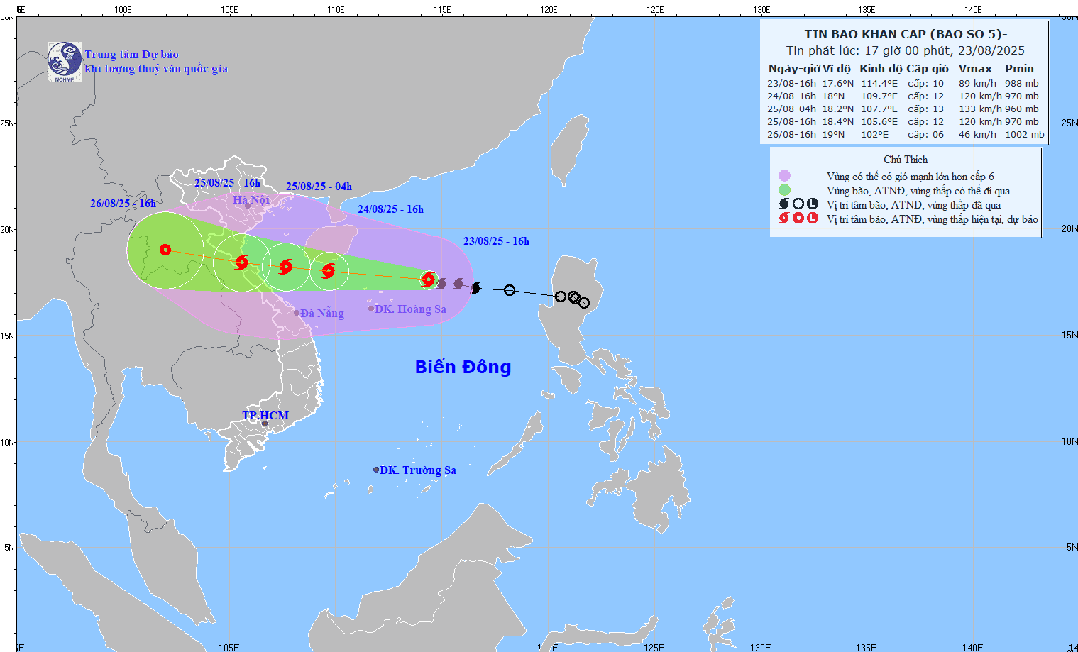
Latest update from the National Center for Hydro-Meteorological Forecasting, at 4:00 p.m. on August 23, the center of the storm was at about 17.6 degrees north latitude; 114.4 degrees east longitude, about 230 km east-northeast of Hoang Sa Special Zone. The strongest wind near the storm center is level 9 - 10 (75 - 102 km/h), gusting to level 12.

Storm No. 5 makes landfall from noon to afternoon of August 25
According to Mr. Mai Van Khiem - Director of the National Center for Hydro-Meteorological Forecasting, in the next 24 hours, the storm is forecast to move west-northwest at a speed of 20 - 25 km/h and continue to strengthen.
At 4:00 p.m. on August 24, the center of the storm was at about 18 degrees north latitude; 109.7 degrees east longitude, in the sea south of Hainan Island (China). Strong wind level 12, gust level 14. The danger zone is from 16 to 20 degrees north latitude; from 107.5 to 116.5 degrees east longitude. The natural disaster risk level is level 3, affecting the northern East Sea (including Hoang Sa special zone), the Gulf of Tonkin and the southern sea area of Quang Tri - Thua Thien Hue.
It is forecasted that in the next 36 hours, the storm will move west-northwest at a speed of 15 - 20 km/h.
At 4:00 a.m. on August 25, the center of the storm was at about 18.2 degrees north latitude; 107.7 degrees east longitude, in the sea from Thanh Hoa to Quang Tri. Strong wind level 12 - 13, gust level 15.
"Around noon to afternoon of August 25, storm No. 5 will make landfall in the provinces from Thanh Hoa to northern Quang Tri. The strongest wind near the storm center is level 11 - 12, gusting to level 14" - Mr. Khiem said.
At 4:00 p.m. on August 25, the center of the storm was at about 18.4 degrees north latitude; 105.6 degrees east longitude, on the mainland of the provinces from Thanh Hoa to northern Quang Tri.
According to Mr. Khiem, it is forecasted that in the next 72 hours, the storm will move west-northwest at a speed of 15 - 20 km/h, gradually weakening into a tropical depression.
At 4:00 p.m. on August 26, the center of the tropical depression was at about 19 degrees north latitude; 102 degrees east longitude, on the mainland of central Laos. Strong wind level 6, gust level 8.
Thanh Hoa to northern Quang Tri has some places with over 700mm of rain
Regarding the impact of storm No. 5, according to the meteorological agency, the sea area north of the East Sea (including Hoang Sa special zone) has strong winds of level 8 - 9, near the storm center level 11 - 12, gusts of level4; waves 4 - 6 m high, the sea is very rough.
From noon and afternoon of August 24, the sea area from Thanh Hoa to Hue (including Hon Ngu island, Con Co special area) will have winds gradually increasing to level 6 - 8, then increasing to level 9 - 10, near the storm center will have winds of level 11 - 13, gusts of level 15; waves 4 - 6 m high, near the storm center 7 - 9 m, the sea will be very rough.
On the afternoon of August 24, the northern Gulf of Tonkin (including Cat Hai, Co To, Van Don special areas) will have winds gradually increasing to level 6 - 7, gusting to level 9; In the south, the northern Gulf of Tonkin (including Bach Long Vi special area) will have strong winds of level 8, gusting to level 10, waves 2 - 4 m high, rough seas.
Coastal areas from Ninh Binh to northern Quang Tri have storm surges of 0.5 - 1.2 m. Water levels in Sam Son (Thanh Hoa) are 3.2 - 3.6 m high, in Hon Ngu (Nghe An) are 3.3 - 3.8 m high, in Vung Ang (Ha Tinh) are 2.2 - 2.8 m high, in Cua Gianh (Quang Tri) are 1.5 - 2 m high. High risk of flooding in low-lying coastal areas, river mouths, islands from Thanh Hoa to northern Quang Tri.
Mr. Khiem especially warned of strong winds on land from the night of August 24. The provinces from Thanh Hoa to Quang Tri will have winds gradually increasing to level 7 - 9, near the storm center level 10 - 12, gusting to level 14 - 15. Coastal areas from Quang Ninh to Ninh Binh will have winds gradually increasing to level 6 - 7, gusting to level 8.
From the night of August 24 to the end of August 26, in the Northern Delta, southern Phu Tho and from Thanh Hoa to Hue, there will be widespread heavy rain.
"The rainfall this time is generally 100 - 150 mm, locally over 250 mm, especially from Thanh Hoa to northern Quang Tri, there will be heavy to very heavy rain with common rainfall of 200 - 400 mm, locally over 700 mm. There is a risk of extremely heavy rain over 200 mm in 3 hours" - Mr. Khiem warned.
Mr. Khiem added that from August 25 to 26, the capital Hanoi and Da Nang city will have moderate rain, heavy rain and thunderstorms; Ho Chi Minh City will have showers and thunderstorms in the late afternoon and evening. From August 25 to 27, the upper and middle areas of Laos will have heavy rain with a common amount of 100 - 250 mm, in some places in central Laos over 500 mm.


