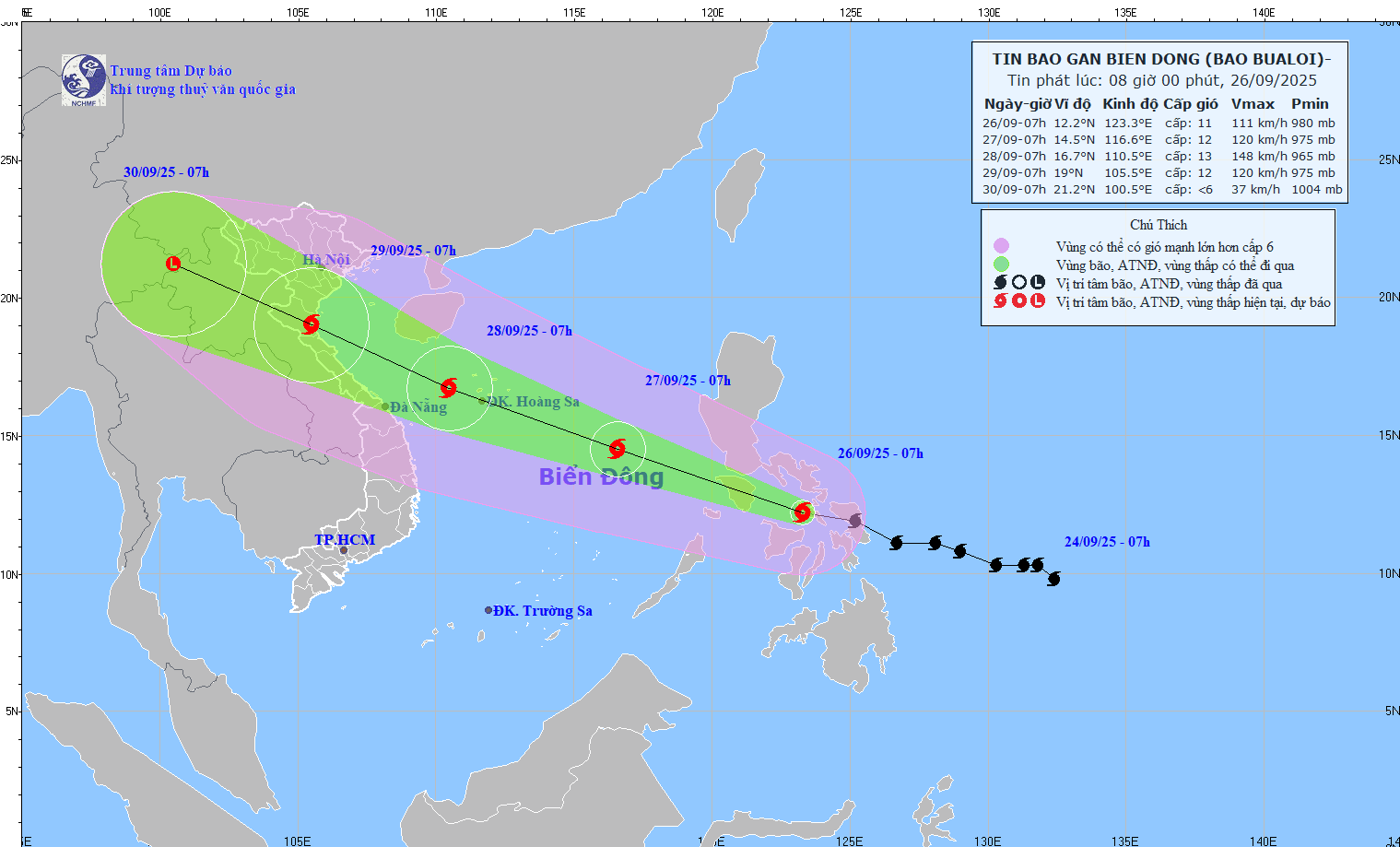
The latest update from the National Center for Hydro-Meteorological Forecasting, at 9:00 a.m. on September 26, the center of storm Bualoi was at about 12.3 degrees north latitude; 122.6 degrees east longitude, in the central Philippines. Strong storm intensity level 11, gust level 14.
According to Mr. Hoang Phuc Lam - Deputy Director of the National Center for Hydro-Meteorological Forecasting, around tonight (September 26), storm Bualoi will enter the eastern sea area of the central East Sea, becoming the 10th storm of 2025.

"After entering the East Sea, the storm will move west-northwest at a very fast speed (average 30km/h, twice as fast as normal storms)" - Mr. Lam analyzed.
According to the representative of the meteorological agency, the storm will head towards the western sea of Hoang Sa special zone around September 28, with the intensity likely to reach level 13, gusting to level 15.
"The storm is forecast to then change direction, moving along the coast towards the North Central and South Dong Bang provinces of the North, the time the storm will directly affect is around September 29. From September 28 to 30, the Northern region will have very heavy rain in Thanh Hoa - Hue" - Mr. Lam provided a new assessment of the impact of the storm.
Heavy rain is likely to cause flooding in low-lying areas, urban and industrial areas; flash floods on small rivers and streams, landslides on steep slopes.
Real-time warning information for areas at risk of flash floods and landslides is provided online on the website of the Department of Hydrometeorology at: https://luquetsatlo.nchmf.gov.vn and in a separate bulletin warning of flash floods and landslides.
In addition, from the afternoon of September 26, the sea area east of the northern and central East Sea will have strong winds of level 6 - 7, then increase to level 8 - 9, the area near the storm center will have level 10 - 12, gusting to level 15. Waves are 5-7m high, the sea is very rough.
Day and night of September 27, the North and Central East Sea (including Hoang Sa special zone) will have strong winds of level 9 - 10, near the storm's eye will have winds of level 11 - 13, gusts of level6; waves of 6 - 8m high; the sea will be very rough.
The sea area from Gia Lai to Ho Chi Minh City and the South East Sea area (including Truong Sa special zone) has southwest winds gradually increasing to level 6, gusting to level 8 - 9; waves 2 - 4m high; rough seas.
In the evening and night of September 27, the Gulf of Tonkin will have northeast to north winds gradually increasing to level 6 - 7, gusting to level 8 - 9; waves 2 - 4m high. Strong seas.
The sea area from South Quang Tri to Quang Ngai will have north to northwest winds gradually increasing to level 6 - 8, gusting to level 9 - 10; waves 3 - 5m high, rough seas.