The National Center for Hydro-Meteorological Forecasting has issued a noteworthy weather trend forecast for the next month (from now until March 20). Accordingly, the nature of cold air in this period will change, causing some noteworthy weather changes.
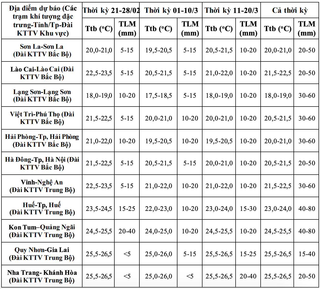
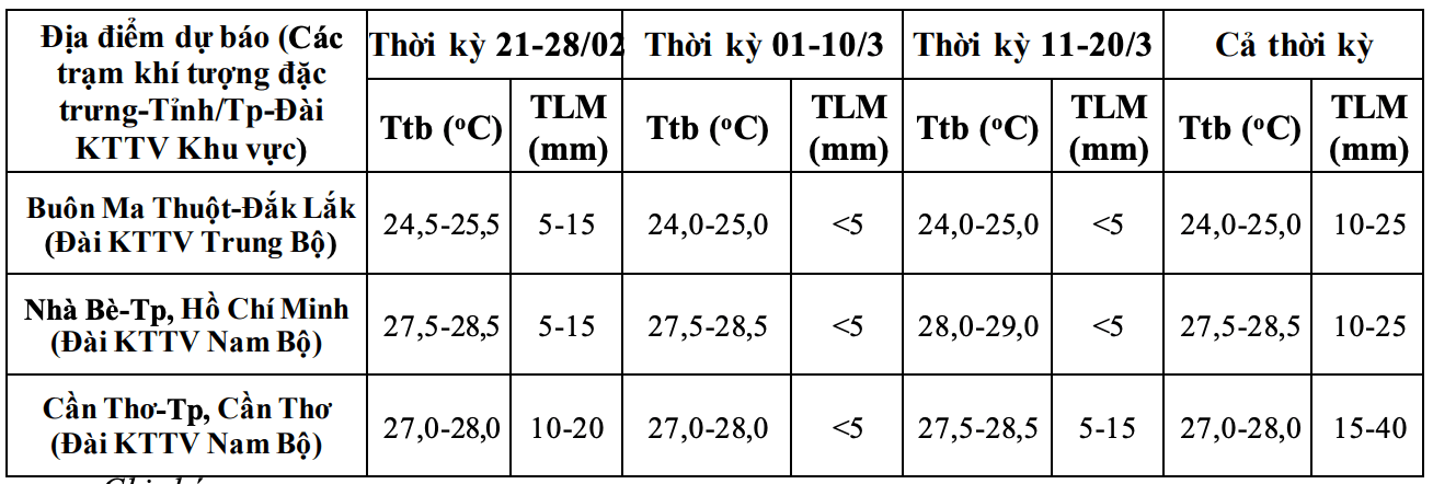
Regarding the temperature trend, nationwide, the average temperature is generally approximately equal to the average of many years in the same period.
According to Mr. Nguyen Duc Hoa - Deputy Head of the Climate Forecasting Department, National Center for Hydro-Meteorological Forecasting, cold air from now until March will continue to operate and tend to deviate to the east.
The phenomenon of severe cold - harmful cold occurs mainly in the mountainous and midland areas of the Northern region. Light rain, drizzle with fog in the northeastern and North Central provinces in the next month will be at a level equivalent to the multi-year average" - Mr. Hoa said.

Previously, in the period from January 21 to February 20, there were 4 cold air waves (January 21, January 31, February 8 and February 17).
According to the Deputy Head of the Climate Forecasting Department, from now until March, hot weather is forecast to continue to occur in the Southeast region, locally in the Mekong Delta region.
Previously, the Southeast region had some days of localized hot weather; in which, February 16 and February 18-19 had widespread hot weather.
Faced with such weather trends, the meteorological agency continues to recommend that cold air is likely to cause strong winds and big waves affecting the activities of ships and boats. On land, light rain, drizzle and fog, especially in the northeastern and North Central provinces, will affect people's activities as well as traffic.
In addition, severe cold affects the growth and development of crops in the northern mountainous provinces; hot weather can affect the lives and production of people in the southern region.
Regarding the rainfall trend, in the next month, the total rainfall in areas nationwide is generally approximately or higher than the multi-year average of the same period from 10 - 30mm, in some places higher than 30mm.
Ha Tinh - Hue and the South Central Coast regions are likely to experience some widespread rains. The Southern region may experience some days of unseasonal rain. Dangerous weather phenomena such as thunderstorms, tornadoes, lightning, hail and strong gusts of wind are likely to occur locally" - Mr. Hoa added.
Regarding sea weather, in the next month, it is forecast that storms/tropical depressions are unlikely to appear in the East Sea area. According to multi-year averages, there are 0.1 storms/tropical depressions in the East Sea, not making landfall in Vietnam.
In the context of climate change, weather, and climate are increasingly complicated with many dangerous and extreme forms such as heavy rain in a short time, flash floods, landslides...
Therefore, the meteorological agency requests all levels of government and people to regularly update and integrate meteorological and hydrological forecasting and warning information in 1-3-day short-term bulletins, to promptly adjust production plans, appropriate response plans, especially appropriate reservoir operation plans, ensuring the safety of works and downstream areas, along with ensuring safety for production and people's livelihoods.


