The latest storm information from the US Navy's Joint Typhoon Warning Center (JTWC) said that Typhoon Wipha has been moving west at a speed of 19 km/h for the past 6 hours.
Over the past few hours, Typhoon Wipha has moved more northwest than initially expected but will not significantly change the forecast path of the storm.
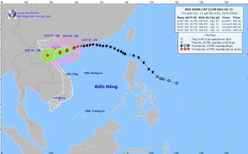
At 8:00 p.m. on July 20, JTWC forecasters said that Wipha will reach the farthest northeast of the Gulf of Tonkin in the next few hours, then begin to weaken as the northern low pressure strip is broken by a high pressure trough.
After entering the Gulf of Tonkin, Typhoon Wipha will be on the water for about 24 to 30 hours before making landfall in the Red River Delta for about 36 hours.
The speed of storm No. 3 in the East Sea is forecast to increase again due to the influence of the tropical depression forming in the northwest of the storm.
According to the JTWC's forecast, from mainland China to the Gulf of Tonkin, Typhoon Wipha will have favorable conditions to strengthen again. Sea surface temperatures in some places in the Gulf of Tonkin exceeded 31 degrees Celsius.
Therefore, it is likely that Wipha will strengthen at least to the intensity of a tropical storm and is likely to return to strong storm intensity before making landfall in Vietnam.
After making landfall in Vietnam, Typhoon Wipha is forecast to weaken rapidly and dissipate in the northern Laos region within 3 days.
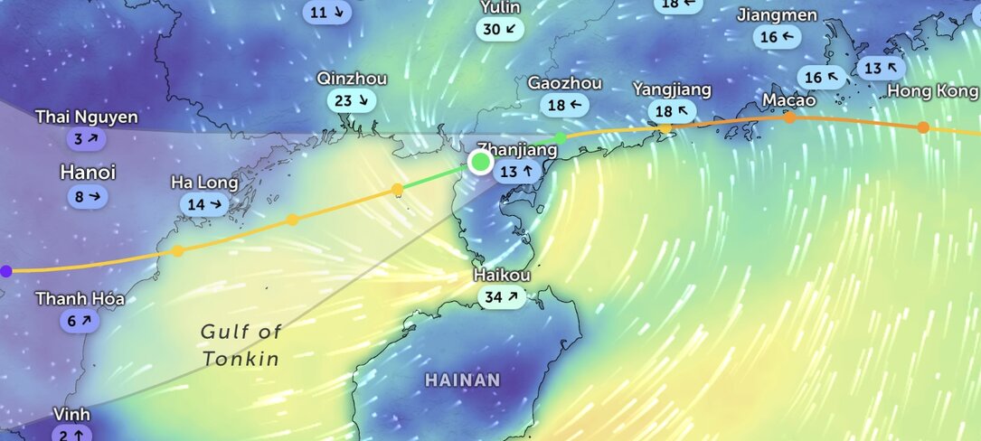
The latest storm news on the morning of July 21 from weather forecasters in China said that Typhoon Wipha caused heavy rain and strong gusts of wind across Hong Kong (China) before making landfall in Guangdong province, China and gradually weakening. Currently, Vietnam is expected to be the next area affected by Typhoon Wipha.
Typhoon Wipha brought heavy rain, rising sea levels and maximum sustained winds of 100 km/h to Hong Kong (China) on the afternoon of July 20, according to the Hong Kong Meteorological Agency (China).
Due to the impact of the storm, 253 people have sought shelter in government shelters, 26 people have gone to public hospitals for treatment. There were 471 reports of fallen trees.

According to the typhoon bulletin of the National Meteorological Center of China, Typhoon Wipha made landfall in Taizhou, a city in Guangdong Province, at around 5:50 p.m. on July 20.
Immediately after making landfall, the storm weakened into a strong tropical storm. Chinese typhoon forecasters say Wipha will gradually weaken as it moves along the west coast of Guangdong before making landfall on the northern coast of Vietnam late on July 21.
According to the Philippine Atmospheric, Geophysical and Astronomical Services Administration (PAGASA), Typhoon Wipha also caused a major thunderstorm in Taiwan (China) on July 19 and increased rainfall due to the southwest monsoon in the Philippines.
moderate to light rains and thunderstorms are forecast in some areas of the Philippines until July 21. Thousands of people have taken shelter at government facilities and two are missing in the Philippines due to the impact of Typhoon Wipha.