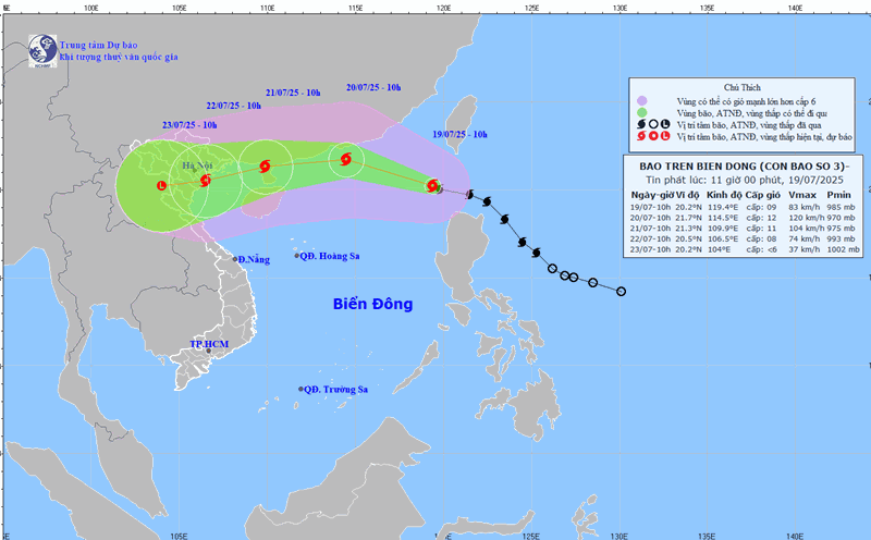
The latest storm news on the morning of July 19 from the Philippine Atmospheric, Geophysical and Astronomical Services Administration (PAGASA) said that storm Crising (international name Wipha) still maintains its strong intensity and will not make landfall in the Philippines. The latest storm near the South China Sea is currently moving offshore in Northern Luzon.
According to available data, the center of Crising is 125km northwest of Calayan, Cagayan, Philippines. The storm is moving west-northwest at a speed of 25 km/h. Maximum sustained winds near the center are 85 km/h and gusts of up to 105 km/h.
Philippine typhoon forecasters said that Crising will continue to move mainly westward, northwestward south of China and may exit the Philippine forecast area this morning or early afternoon. Storm Crising is forecast to continue to strengthen and strengthen into a severe tropical storm as it heads towards the East Sea.
Philippine forecasters said that at around 2:00 p.m. on July 21, the storm expected to become the third storm in the East Sea will be in the waters bordering Quangdong province, China.
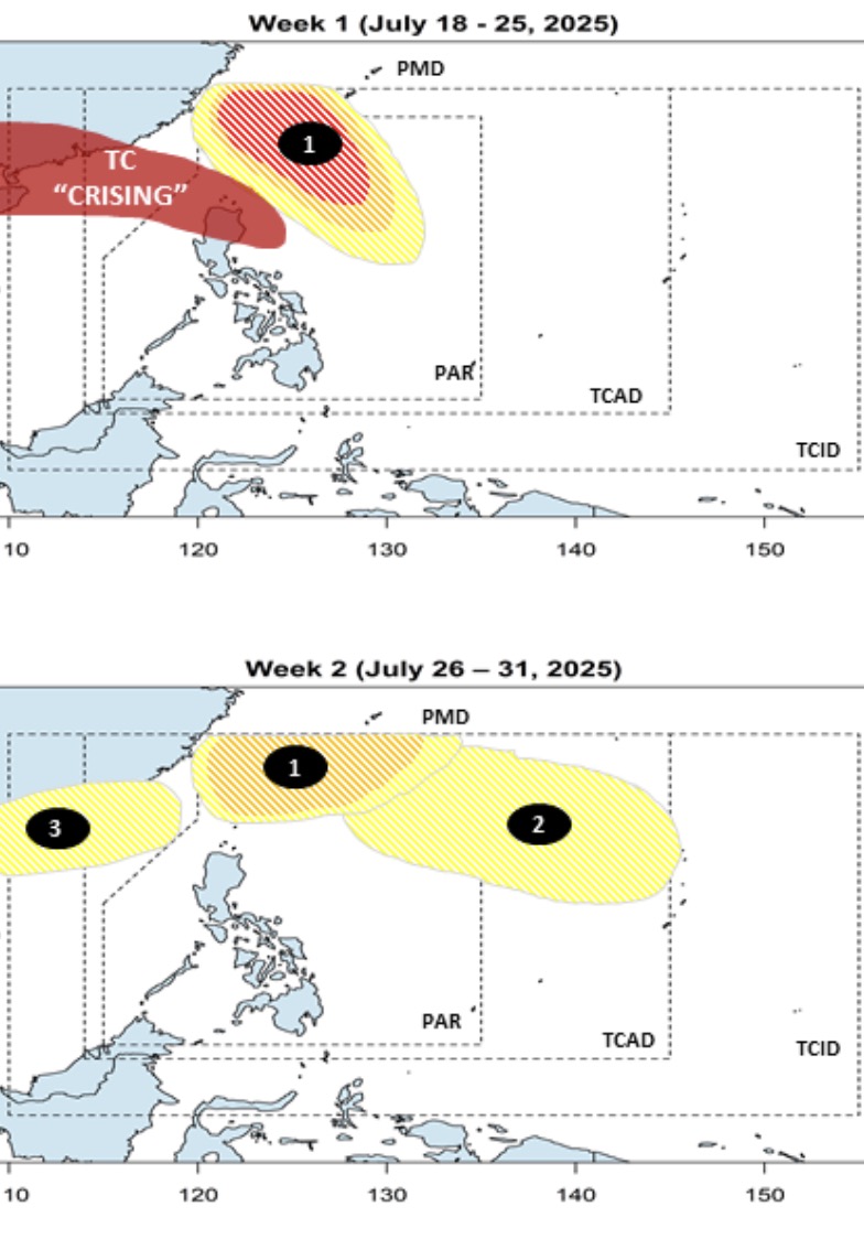
While Typhoon Wipha moves into the South China Sea, Philippine weather forecasters also see three low pressure areas expected to form in the South China Sea and near the South China Sea, including one that is likely to strengthen into a typhoon.
PAGASA's typhoon forecast bulletin on July 18 said that the low pressure near the East Sea that formed right after Typhoon Wipha will appear in the east of Northern Luzon, within the PAR warning area. This low pressure near the East Sea is forecast to move north, with the possibility of continuously strengthening into a storm during the period from July 18 to July 25.
Forecast models show that this low pressure near the East Sea is forecast to continue to operate until next week from July 26 to July 31, with the possibility of moving towards Taiwan (China) and Ryukyu (Japan). However, during this period, the system is likely to strengthen into a low to moderate storm.
Also during this period, a second low pressure near the East Sea will appear at the northeastern boundary of PAGASA's PAR and TCAD forecast areas. This low pressure is unlikely to strengthen into a storm.
Notably, during this period, the third low pressure will form as a low pressure in the East Sea. This low pressure is assessed by weather experts in the Philippines as appearing in the northwest boundary of PAGASA's PMD. This low pressure in the East Sea could be a new low pressure or could also be a remnant of Typhoon Wipha.