Super typhoon No. 9 in the East Sea continues to accelerate

Song Minh |

Typhoon Ragasa is accelerating strongly in the sea east of Luzon Island (Philippines) and is forecast to become the Ninth super typhoon in the East Sea.

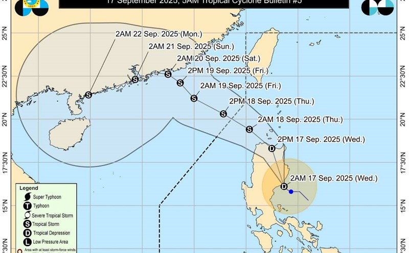
The latest storm information from the Philippine Atmospheric, Geophysical and Astronomical Services Administration (PAGASA) said that tropical depression Nando strengthened into a tropical storm with the international name Ragasa at 11pm on September 18 (local time).

At 4:00 a.m. on September 19, the center of the storm was at about 16.1 degrees North latitude; 132.2 degrees East longitude, about 1,075km east of the center of Luzon, with the strongest wind reaching 75 km/h, gusting to 90 km/h, central pressure 998 hPa.

Typhoon Ragasa is moving west-northwest at a speed of 15 km/h. The level 8 gusts have extended to 380km from the center of the storm.

The tropical depression will strengthen into Typhoon Ragasa on the night of September 18, 2025. Source: Cyclonicwx.com

PAGASA said the storm will continue to strengthen in the next 24 hours and may reach typhoon level by the evening of September 20. The risk of Nando becoming the Ninth super typhoon in the South China Sea when sweeping across the northernmost part of Luzon is completely ruled out.

According to the forecast track of potential storm No. 9, the storm will maintain its West-Northwest direction over the Philippine Sea today (September 19), possibly moving in a small loop before changing course to the West later in the day.

The center of the storm is expected to make landfall near or directly in the Babuyan Islands between the evening of September 22 and the morning of September 23, then leave the Philippine forecast area on September 23 and enter the East Sea.

In the next 48 hours, Typhoon Ragasa is unlikely to directly affect the Philippine mainland. However, from September 21-22, widespread heavy rains may begin due to the combination of storm circulation and the Southwest monsoon.

The US Joint Typhoon Warning Center (JTWC) assessed the current environmental conditions as very favorable for the storm's intensification: High sea surface temperatures 29-30°C, low wind shear (19-28 km/h) and strong equatorial discharge systems. These factors give Ragasa the opportunity to accelerate rapidly in the next few days.

Du bao duong di va cap do cua bao Ragasa. Anh: JTWC
Forecast of the path towards the East Sea and the level of storm Ragasa. Photo: JTWC

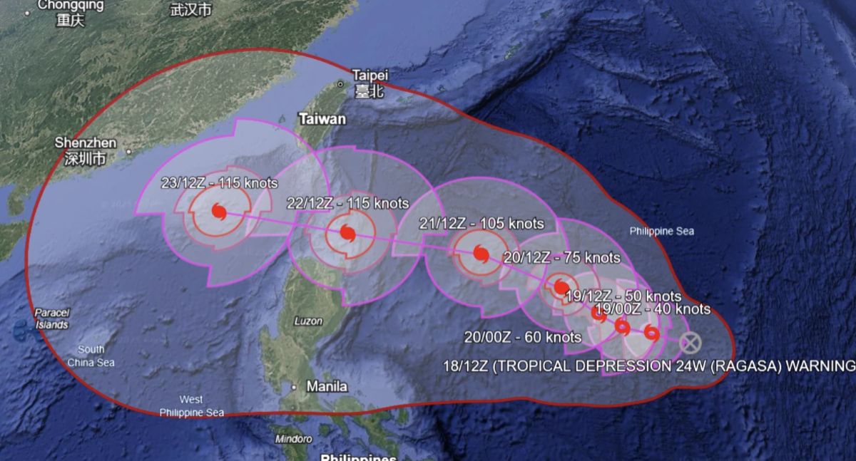
Currently, Typhoon Ragasa has not directly impacted the East Sea. However, in the strongest scenario, Typhoon Ragasa could enter the East Sea with great intensity, becoming the ninth super typhoon of this year's typhoon season.

Regarding storm No. 8 in the East Sea, according to the Vietnam National Center for Hydro-Meteorological Forecasting, at 4:00 a.m. on September 19, the center of the storm was at about 21.5 degrees North latitude; 116.1 degrees East longitude, in the northern sea area of the North East Sea, about 240km East Southeast of Hong Kong (China).

Du bao duong di cua bao so 8. Anh: Trung tam Du bao Khi tuong Thuy van Quoc gia Viet Nam
Forecast of the path of storm No. 8. Photo: Vietnam National Center for Hydro-Meteorological Forecasting

The strongest wind near the storm center is level 8-9 (62-88km/h), gusting to level 11. The storm is moving northwest at a speed of 15km/h.

Due to the influence of storm No. 8, the sea area north of the North East Sea will have strong winds of level 6-7, gusting to level 9; The area near the storm's eye will have strong winds of level 8-9, gusting to level 11, waves 3.0-5.0m high. The sea is very rough. Ship operating in the above-mentioned dangerous areas are likely to be affected by thunderstorms, whirlwinds, strong winds, and large waves.

Song Minh
RELATED NEWS

Storm No. 8 in the East Sea forms, potential super typhoon No. 9 is accelerating

|

Typhoon No. 8 in the East Sea, international name Mitag, formed at noon on September 18.

Storm No. 8 in the East Sea has not yet ended, storm No. 9 is weak, could become a super typhoon

|

Tropical depression Mirasol has entered the East Sea, expected to strengthen into storm No. 8, while tropical depression Nando may strengthen into storm No. 9.

Hanoi Secretary proposed to be awarded a Medal

|

Secretary of the Hanoi Party Committee Nguyen Duy Ngoc was proposed to be awarded the First Class Military Exploit Order for his outstanding achievements in implementing Project 06.

Photo of the company's salary table when submitting social housing applications - risk of violating business secrets

|

Hanoi - People submitting documents at the CT3 Kim Chung social housing project were asked to take photos of the entire company's salary table, raising concerns about violating business secrets.

Advising Vietnamese citizens on the situation at the Thailand - Cambodia border

|

On December 11, the Consular Department - Ministry of Foreign Affairs advised Vietnamese citizens about the situation at the Thai - Cambodian border.

HCMC Chairman directs urgent expansion of central road 3 times

|

Ho Chi Minh City agreed to include the Tran Binh Trong road expansion project (from Ly Thai To to Hung Vuong) in the list of investment capital support projects for the period 2026 - 2030.

The woman counted every penny to buy warm clothes for her husband, causing strong emotions

|

Lao Cai - A woman in H'Mong costume in Tram Tau brought a stack of change to buy warm clothes for her husband.

An Giang Provincial Department of Construction provides more information about the underground cable incident in Phu Quoc

|

An Giang - The police are investigating to determine the cause of the underground cable incident that affected Phu Quoc's power supply.

Storm No. 8 in the East Sea forms, potential super typhoon No. 9 is accelerating

Song Minh |

Typhoon No. 8 in the East Sea, international name Mitag, formed at noon on September 18.

Storm No. 8 in the East Sea has not yet ended, storm No. 9 is weak, could become a super typhoon

Khánh Minh |

Tropical depression Mirasol has entered the East Sea, expected to strengthen into storm No. 8, while tropical depression Nando may strengthen into storm No. 9.

Dự báo vùng ảnh hưởng nặng nhất của bão số 8 tiềm năng trên Biển Đông

Khánh Minh |

Áp thấp nhiệt đới Mirasol được dự báo có khả năng mạnh lên thành bão và đi vào Biển Đông, trở thành bão số 8.