On September 15, the Philippine Atmospheric, Geophysical and Astronomical Services Administration (PAGASA) issued an urgent warning: The La Nina phenomenon may form as early as October 2025, leading to heavy rain, more storms and a risk of severe flooding and landslides in many vulnerable areas.
According to the latest forecast, there is a 70% chance of La Nina appearing between October and December 2025 and could extend to February 2026.
In this situation, PAGASA has raised the ENSO warning level to La Nina warning - meaning that this phenomenon is likely to form within the next 2 months.
History shows that La Nina often comes with more tropical cyclones than average at the end of the year, causing widespread heavy rains, PAGASA stressed.
Recent forecasts also show the probability of more than normal rainfall in most areas of the Philippines in the coming months.
The cause is believed to be due to the combined impact of monsoons, strong thunderstorms, low pressure areas, easterly winds, low pressure troughs and tropical convergence zones. These are factors that can increase flooding, flash floods and landslides in many provinces and cities.
PAGASA calls on people and authorities not to be subjective and prepare for response measures. PAGASA will continue to closely monitor the development of La Nina and its impact on the Philippine climate. All relevant agencies and communities are advised to increase vigilance, regularly update weather forecasts, and promptly deploy preventive measures, PAGASA emphasized.
La Nina - in contrast to El Nino - is a phenomenon in which sea surface temperatures in the equatorial Pacific Ocean drop below normal, often causing heavy rain, flooding and strong storms in many countries in the Asia-Pacific region.
On September 16, there are 3 low pressure areas in the East Sea and the Philippine Sea.
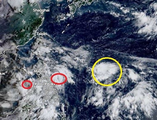
According to the latest storm news from PAGASA, at 8:00 a.m. on September 16, the low pressure area in the central East Sea (code 09c) was at about 12.7 degrees North latitude, 115.3 degrees East longitude, 540km west of Coron, Palawan. It is forecasted that in the next 24 hours, the low pressure area will move in the West Northwest direction, traveling about 15km per hour and is likely to strengthen into a tropical depression.
The low pressure area in the Philippine Sea (09d) at 8:00 a.m. on September 16 was at 14.4 degrees North latitude, 125.0 degrees East longitude, likely to strengthen into a tropical depression from September 18 and may then strengthen into a storm.
In the next few days, this low pressure area will move north towards the area between Luzon and Taiwan (China), then, under the impact of the Chinese continental high pressure, the storm/tropical depression will tend to change direction to the West and enter the East Sea or on the southern mainland of China. If the continental high pressure dominates, storms/tropical depressions may be pushed towards Central Vietnam.
A third low pressure is forming off the coast of the eastern Philippines. It is not ruled out that this low pressure may enter the East Sea in the period of September 23-24.