Storm No. 8 in the East Sea has not yet ended, storm No. 9 is weak, could become a super typhoon

Khánh Minh |

Tropical depression Mirasol has entered the East Sea, expected to strengthen into storm No. 8, while tropical depression Nando may strengthen into storm No. 9.

The latest storm information from the Philippine Atmospheric, Geophysical and Astronomical Services Administration (PAGASA) said that on the night of September 17, tropical depression Mirasol in the sea northwest of Luzon Island (Philippines) entered the East Sea.

At 4:00 a.m. on September 18, the center of the tropical depression was at about 19.2 degrees North latitude; 119.9 degrees East longitude, in the northeastern sea of the North East Sea, 165km west of Calayan, Cagayan.

The strongest wind near the center of the tropical depression is level 7 (55 km/h), gusting to level 9 (90 km/h).

The tropical depression is moving northwest at a speed of about 15-20 km/h. The range of strong winds extends outwards to 200km from the center of the tropical depression.

The storm forecast of the Vietnam National Center for Hydro-Meteorological Forecasting said that at 1:00 a.m. on September 19, the center of the tropical depression was at 21.3 degrees North latitude, 117.1 degrees East longitude; in the northeastern sea area of the North East Sea.

Intensity level 8, gust level 10. Moving northwest at 15-20 km/h and likely to strengthen into storm No. 8.

Du bao duong di cua ap thap nhiet doi tren Bien Dong. Anh: Trung tam Du bao Khi tuong Thuy van Quoc gia Viet Nam
Forecast of the path of the tropical depression in the East Sea. Photo: Vietnam National Center for Hydro-Meteorological Forecasting

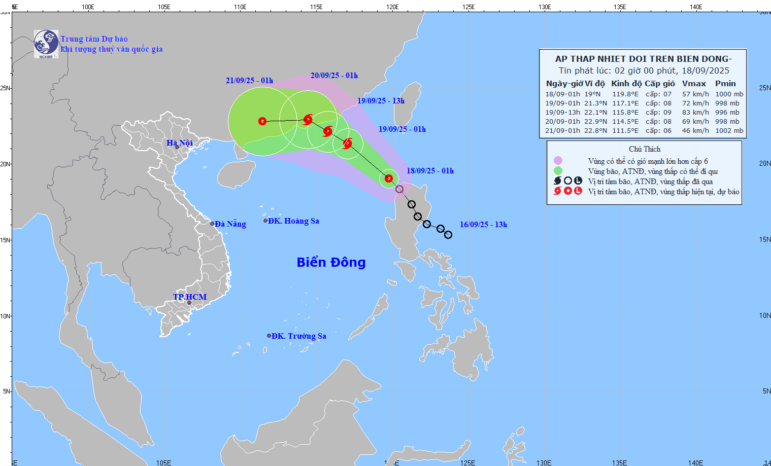
At 1:00 a.m. on September 20, the center of tropical depression/storm No. 8 was at 22.9 degrees North latitude, 114.5 degrees East longitude; in the southern area of Guangdong province (China). Intensity level 8, gust level 10, moving northwest, about 15 km/h.

Thus, storm No. 8 is not forecast to make a direct landfall in Vietnam.

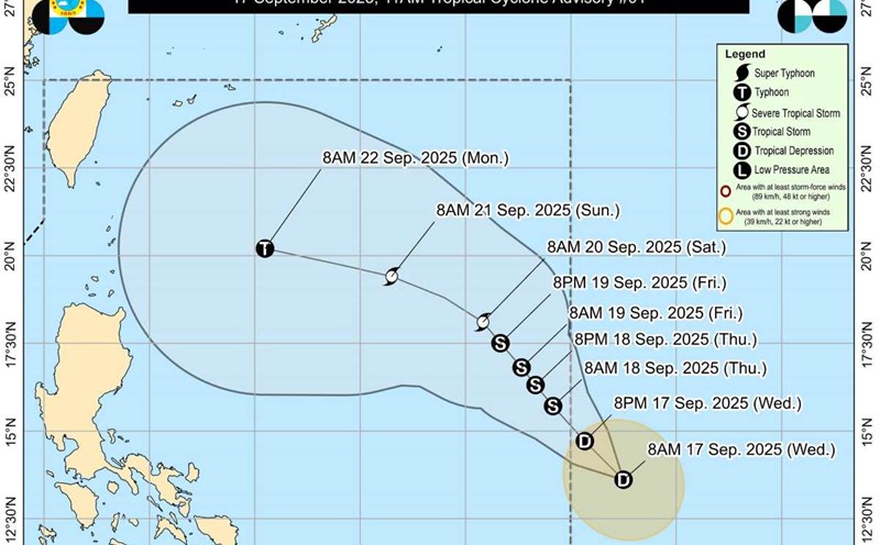
Meanwhile, according to PAGASA, Tropical Depression Nando in Southeast Luzon is a new worrying system. The center of the tropical depression at 4:00 a.m. on September 18 was at 14.9 degrees North latitude, 134.3 degrees East longitude, 1,225 km east of Southeast Luzon.

Intensity: Maximum sustained winds of 55 km/h, gusts of 70 km/h and central pressure of 1004 hPa. Current direction: North Northwest at a speed of 15 km/h. The range of strong winds extends outwards to 200km from the center.

Ap thap nhiet doi Nando co kha nang vao Bien Dong, tro thanh con bao so 9. Anh: PAGASA
Tropical depression Nando is likely to enter the East Sea, becoming storm No. 9. Photo: PAGASA

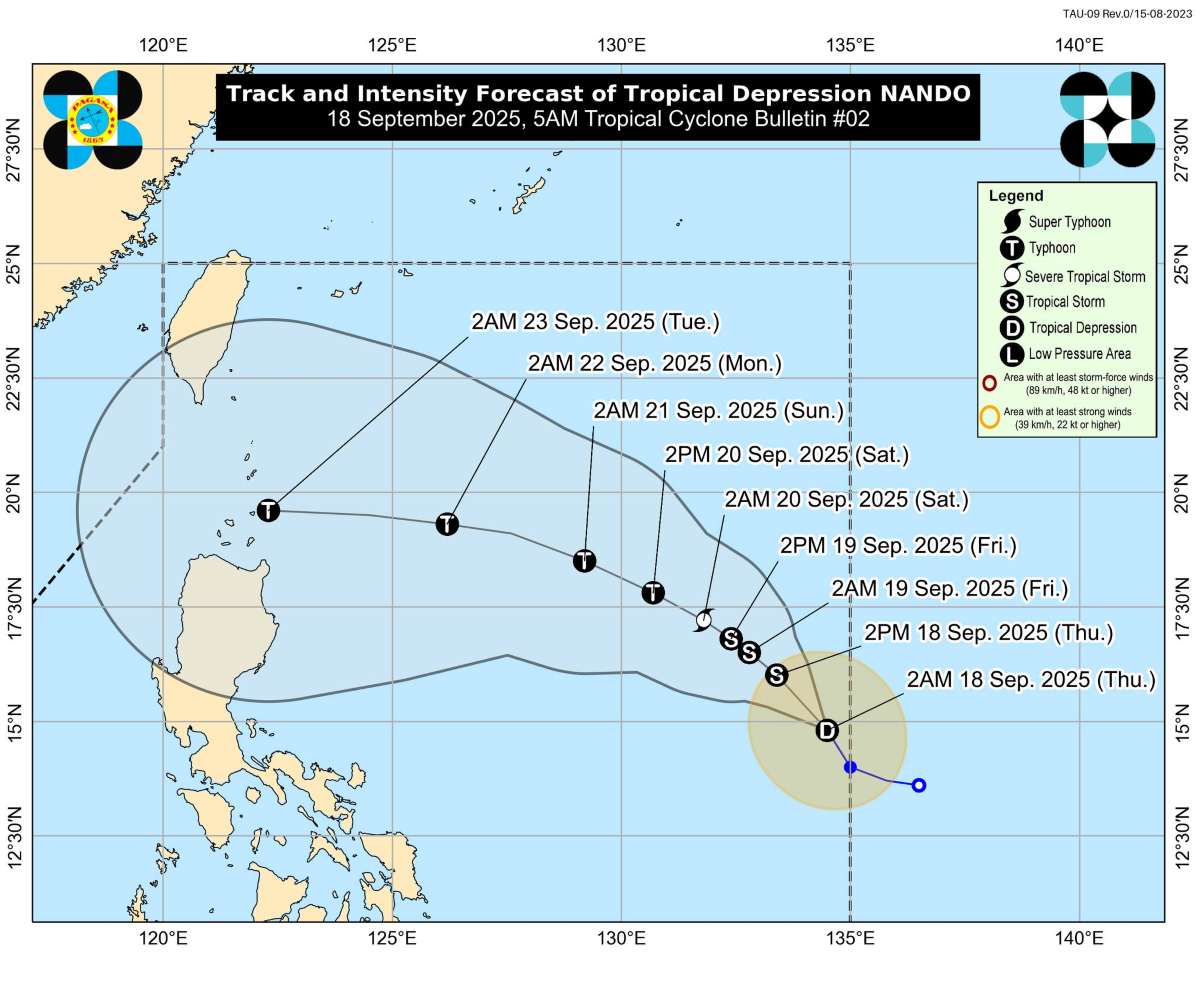
Nando is forecast to move slowly northwest over the Philippine Sea over the next 48 hours. The tropical depression will then turn west-northwest on Saturday afternoon (20.9) towards the northernmost tip of Luzon.

Nando will continue to strengthen as it passes through the Philippine Sea and may reach typhoon level on Saturday (20.9).

On September 22, the storm is likely to approach the north of Luzon Island, according to the synthesis of models, it is likely to enter the North East Sea area on September 23-24, becoming storm No. 9.

According to PAGASA, the storm could even reach super typhoon intensity before passing very close to or through the Batanes-Babuyan region on September 23.

Khánh Minh
RELATED NEWS

Another low pressure near the East Sea intensifies, forecast to become a strong storm

|

On the morning of September 17, the low pressure area near the East Sea in the southeast of the Philippines strengthened into a tropical depression and is likely to become a storm in the coming days.

La Nina is about to hit, warning of heavy rain, storm after storm

|

La Nina could appear as early as October, bringing heavy rain, strong storms and the risk of widespread flash floods and landslides.

A ward in Hanoi resolves land procedures overdue for 134 days, must apologize to citizens

|

Hanoi - Long Bien Ward is assessed as still having shortcomings and limitations when resolving administrative procedures on land, including dossiers that are overdue for 134 days.

Prenn Pass road closed in Da Lat for 6 days to repair landslide site

|

Lam Dong - Functional agencies decided to close Prenn Pass road for 6 days to repair and fix damaged points caused by previous landslides.

Forecast of the time to end widespread severe cold in the North

|

According to a representative of the meteorological agency, it is forecast that widespread severe cold and frost in the North will last until about January 10, to prevent frost and frost in mountainous areas.

Ho Chi Minh City launches campaign to handle sidewalk and roadway encroachment throughout the area

|

Ho Chi Minh City is deploying a peak period of inspection and handling of sidewalk and roadway encroachment throughout the area to restore urban order.

A restaurant yacht catches fire on the Saigon River

|

Ho Chi Minh City - Restaurant yacht on Saigon River suddenly catches fire, functional forces are controlling the fire.

Another low pressure near the East Sea intensifies, forecast to become a strong storm

Khánh Minh |

On the morning of September 17, the low pressure area near the East Sea in the southeast of the Philippines strengthened into a tropical depression and is likely to become a storm in the coming days.

Dự báo vùng ảnh hưởng nặng nhất của bão số 8 tiềm năng trên Biển Đông

Khánh Minh |

Áp thấp nhiệt đới Mirasol được dự báo có khả năng mạnh lên thành bão và đi vào Biển Đông, trở thành bão số 8.

La Nina is about to hit, warning of heavy rain, storm after storm

Song Minh |

La Nina could appear as early as October, bringing heavy rain, strong storms and the risk of widespread flash floods and landslides.