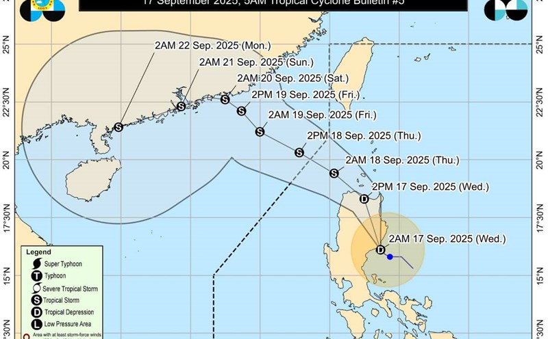
The latest storm information from the Philippine Atmospheric, Geophysical and Astronomical Services Administration (PAGASA) said that at noon on September 18, tropical depression Mirasol had strengthened into a tropical storm with the international name Mitag, the 8th storm in the East Sea and was still being monitored outside the Philippine Forecast Area (PAR).
At 1:00 p.m. on September 18, the center of the storm was at about 19.9 degrees North latitude; 118.4 degrees East longitude, in the northeastern sea of the North East Sea, 450km west of Calayan, Cagayan (Philippines). The strongest wind near the storm center is level 8 (65 km/h), gusting to level 10 (80 km/h). The storm is moving northwest at a speed of 15 km/h.
According to the storm forecast of the Vietnam National Center for Hydro-Meteorological Forecasting, at 1:00 p.m. on September 19, the center of the storm was at 22.4 degrees North latitude, 115.2 degrees East longitude; in the southern coastal area of Guangdong province (China). Storm intensity level 9, gust level 11. Moving northwest, about 15 km/h and continuing to strengthen. The northeastern sea area of the North East Sea is at risk of level 3 natural disasters.
At 1:00 p.m. on September 20, the center of the storm was at 23.2 degrees North latitude, 113.4 degrees East longitude; in the mainland south of Guangdong province (China). Storm intensity level 7, gust level 10. Moving west-northwest, about 10 km/h, it will make landfall and weaken into a tropical depression. The northern sea area of the North East Sea is at risk of level 3 natural disasters.
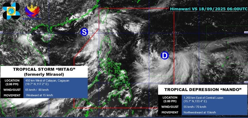
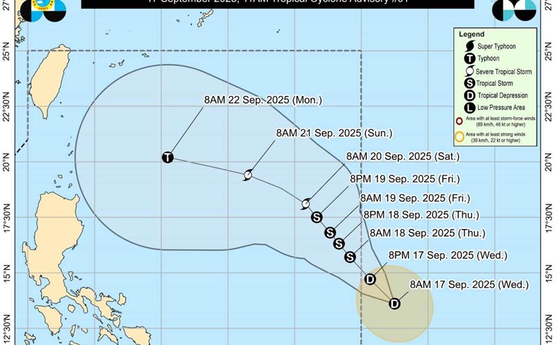
PAGASA is also monitoring tropical depression Nando inside the PAR. At 1:00 p.m. on September 18, the center of the tropical depression was at 15.7 degrees North latitude, 133.4 degrees East longitude, 1,260 km east of Central Luzon. Maximum winds near the center are 55 km/h, gusting to 70 km/h. Moving northwest, 15 km/h.
It is forecasted that around September 23, tropical depression Nando will enter the East Sea and is likely to become the ninth storm active in the region in 2025. This is expected to be an extremely strong storm, even the first super typhoon of 2025, in the Northwest Pacific typhoon.
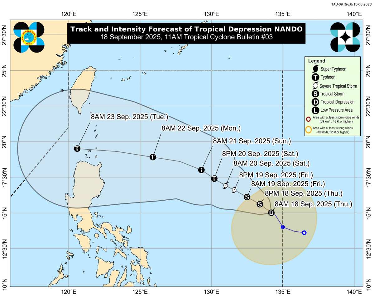
Typhoon AIFS forecast models using artificial intelligence from the European Weather Forecast Center (ECMWF) and the FV3 model from the US National Oceanic and Atmospheric Administration (NOAA) believe that Tropical Depression Nando will almost certainly enter the North East Sea next week and gradually approach the southern coastal area of China, creating a wide-ranging risk of strong winds, with the possibility of prolonging extreme weather conditions in the North East Sea and related coastal areas.