Energy source causes storm number 6 Francine to rapidly increase in intensity

Thanh Hà |

Hurricane Francine is picking up speed and is expected to become a hurricane today.

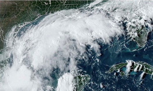
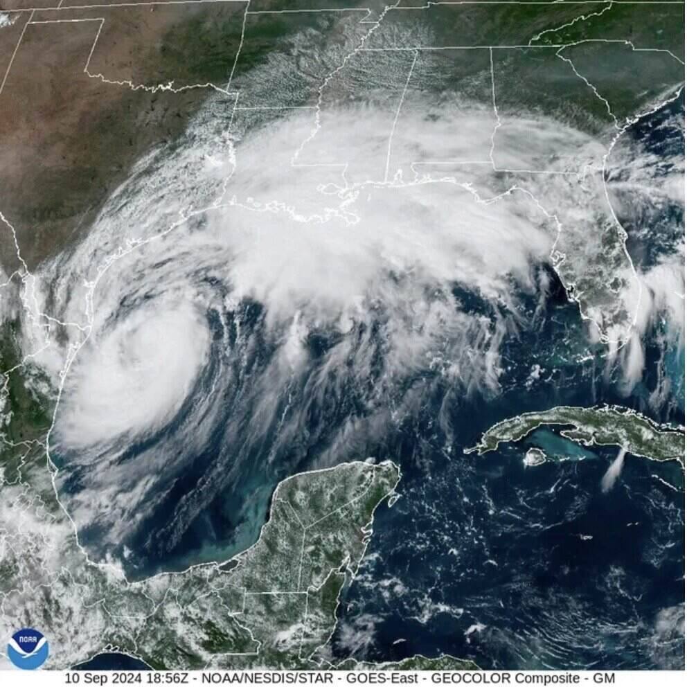
USA Today's latest hurricane report says Hurricane Francine is moving northeast in the Gulf of Mexico. Forecasters expect the latest storm in the Atlantic to reach hurricane status before making landfall on the Louisiana coast today (September 11).

Hurricane Francine is actively strengthening, with high water temperatures in the Gulf of Mexico likely acting as "rocket fuel" for the storm to accelerate, according to AccuWeather hurricane forecaster Alex Dasilva.

Francine is picking up speed, moving at about 10 mph (16 km/h), with sustained winds of 65 mph (105 km/h), 10 mph (16 km/h) below hurricane strength, according to the latest hurricane bulletin from the US National Hurricane Center.

At 5:00 p.m. on September 10, local time, the center of storm No. 6 was nearly 220 km east of the Rio Grande River and nearly 600 km southwest of Morgan City, Louisiana.

Hurricane Francine moves northeast in the Gulf of Mexico. Source: Colorado State University

The latest storm of the 2024 hurricane season is forecast to make landfall along the central Louisiana coast on the afternoon of September 11, between Lafayette and Houma. Francine is expected to move north, dumping heavy rain in Mississippi and then north into the Mississippi Valley as a tropical depression, moving toward Memphis by the night of September 12.

According to the latest hurricane report from the New York Times, Hurricane Francine may be fueled by the warm waters of the Gulf of Mexico. Hurricane Francine is forecast to strengthen into a Category 2 hurricane or even stronger before making landfall.

As of the afternoon of September 9, the seawater temperature in the area of ​​Hurricane Francine has reached the ideal level of warm water in a bathtub, enough to fuel, intensify and sustain a hurricane. As the ideal conditions continue to strengthen, hurricane forecasters are not ruling out the possibility that Francine will become a stronger storm, even a Category 3 or higher.

Brian McNoldy, an expert on hurricane formation and ocean temperatures at the University of Miami, said that if conditions were near perfect, Hurricane No. 6 would likely intensify unexpectedly quickly. Some computer models predicting hurricanes also found that Hurricane Francine could reach Category 3 or 4 strength.

Du bao bao so 6 Francine manh len thanh bao cuong phong trong hom hay. Anh: NOAA
Hurricane Francine is forecast to strengthen into a hurricane later today. Photo: NOAA

Hurricane forecaster McNoldy said energy levels in the waters of the Gulf of Mexico could provide fuel for a storm that would continue to crush hurricane records from 2012.

The National Hurricane Center has also predicted the possibility of a rapid strengthening of the storm in its forecasts. A meteorologist with the National Weather Service in Lake Charles said it is always best to be prepared for a stronger storm than the forecast.

Francine is the sixth storm of the 2024 Atlantic hurricane season and the first hurricane since Hurricane Ernesto in mid-August.

Hurricane Francine is one of three systems being monitored by the U.S. Hurricane Center. A depression in the tropical Atlantic has a 40 percent chance of becoming a tropical storm in the next 48 hours. A depression farther east has a 70 percent chance of becoming a hurricane in the next week.

Thanh Hà
RELATED NEWS

Storm No. 6 evokes the haunting super typhoon of the strongest in the world 2024

|

Hurricane No. 6 Francine is being compared by many to the strongest superstorm Beryl in the world in 2024, making landfall in southeastern Texas (USA) on July 8.

Storm No. 6 Francine forecasts to intensify very quickly

|

The latest storm forecast says that Hurricane No. 6 Francine is strengthening and will become a hurricane by midweek.

Factory fire near gas station in Ho Chi Minh City

|

Ho Chi Minh City - Ho Chi Minh City Police have controlled a factory fire near a gas station in Tan Hiep ward.

Ho Chi Minh City People's Committee headquarters nearly 120 years old will become a tourist attraction

|

Ho Chi Minh City - The headquarters of the People's Council - People's Committee of Ho Chi Minh City on Le Thanh Ton Street (nearly 120 years old) will be preserved and exploited as a tourist and educational destination.

Hanoi Party Secretary sets deadline for completion of "most expensive road on the planet

|

Hanoi - Regarding the progress of the Ring Road 1 project (Hoang Cau - Voi Phuc section), the Hanoi Party Secretary requested to complete the entire roadbed before September 2, 2026; complete the construction of 2 overpasses on the route before December 31, 2026.

Gia Lai drought, people dredge to find water sources to save crops

|

Gia Lai - The western region of the province is entering the dry season, many localities are facing severe water shortages.

Hanoi Traffic Police show trainees videos of accidents before driving test

|

Hanoi - Before the test, traffic police show trainees videos recording serious traffic accidents, thereby making them more aware of their responsibilities when holding the steering wheel.

Complete the installation of medical equipment at facility 2 of Bach Mai and Viet Duc Hospitals before June 30

|

Ninh Binh - The investor of Bach Mai Hospital and Viet Duc Friendship Hospital facility 2 project committed to complete the installation of equipment before June 30.

Storm No. 6 evokes the haunting super typhoon of the strongest in the world 2024

Ngọc Vân |

Hurricane No. 6 Francine is being compared by many to the strongest superstorm Beryl in the world in 2024, making landfall in southeastern Texas (USA) on July 8.

Storm No. 6 Francine forecasts to intensify very quickly

Thanh Hà |

The latest storm forecast says that Hurricane No. 6 Francine is strengthening and will become a hurricane by midweek.

Dự báo thời điểm áp thấp mạnh lên thành bão số 6 Francine

Thanh Hà |

Dự báo bão mới nhất cho hay, áp thấp nhiệt đới có thể mạnh lên thành bão số 6, sau đó thành bão cuồng phong cấp 2 ở Đại Tây Dương.